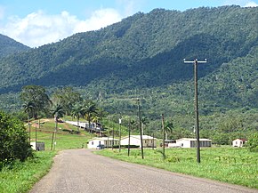
A paving project was completed in 1994. All the citrus produced in Belize travels along this highway to the two major processing plants in Stann Creek district. There are quite a few small villages along the highway. A new bridge was completed over the Sibun River in 2004, and a new bridge inaugurated in 2006 across Silver Creek; however, there are still quite a few one-lane dilapidated bridges over numerous creeks and streams.
The traffic along the Hummingbird Highway has been on the increase lately due to an increase in demand for eco-tourism and the passage of petroleum trucks, which use the Highway as a shortcut en route to the George Price Highway (which terminates at the Guatemala border). The Hummingbird Highway is the only Highway in Belize which cuts through the mountains of Belize. The highway rests in a valley which comprises citrus orchards in the lowland and untouched jungle habitat on the outskirts and beyond.
Transport in Belize mostly consists of bus transportation on Belize's roads. There are some navigable waterways.
The Belize Defence Force (BDF) is the military of Belize, and is responsible for protecting the sovereignty of the country. The BDF is under the Ministry of National Defence and Border Security, which is currently headed by Hon. Florencio Marin Jr.; the BDF itself is commanded by Brigadier General Azariel Loria. In 2012, the Belizean government spent about $17 million on the military, constituting 1.08% of the country's gross domestic product (GDP).
Belize City is the largest city in Belize. It was once the capital of the former British Honduras. According to the 2010 census, Belize City has a population of 61,461 people. It is at the mouth of the Haulover Creek, which is a distributary of the Belize River. The Belize River empties into the Caribbean Sea eight kilometres from Belize City on the Philip Goldson Highway on the coast of the Caribbean. The city is the country's principal port and its financial and industrial hub. Cruise ships drop anchor outside the port and are tendered by local citizens. The city was almost entirely destroyed in October 1961 when Hurricane Hattie swept ashore. It was the capital of British Honduras until the government was moved to the new capital of Belmopan in 1970.
Stann Creek District is a district in the south east region of Belize. According to the 2010 census, the district had a population of 32,166 people. Its capital is the town of Dangriga, formerly known as "Stann Creek Town." Stann comes from "stanns," or safe havens used by colonialists coming from the "old world" to the "new world."
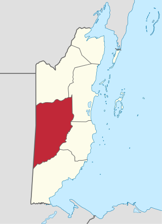
Cayo District is a district located in the west part of Belize. It is the most extensive, second-most populous and third-most densely populated of the six districts of Belize. The district's capital is the town of San Ignacio.
Big Creek or Cala Grande is a deep-water port facility on the Caribbean Sea in Belize's Toledo District, constructed in the 1990s. It is the nation's second largest port, after Belize City. Big Creek is the main port for Belize's banana industry; citrus fruit and shrimp are also exported from here. It is also the location from which oil, extracted from the fields of Spanish Lookout, is exported.
There are several ports of Belize through which boats enter.
The George Price Highway is one of four main highways in Belize. It originates in Belize City, runs west through Hattieville, the Belize Zoo, the capital city of Belmopan, San Ignacio, San José Succotz and terminates at the Guatemalan border at Benque Viejo. The highway bisects the country and ties the eastern and western parts of Belize together. A new steel bridge over Beaver Dam Creek was constructed to replace the broken concrete one.
There is no active rail transport in Belize, although there were lines in the past.
Belize's 6 districts are politically divided into 31 constituencies. Each constituency sends one representative to Belize's House of Representatives for 5-year terms. This election is known as the General Election. Each person votes for the candidate they would want to represent their constituency in Central Government.
The citrus industry in the Caribbean is a major one in the Caribbean. Citrus fruits consists of oranges, grapefruit, tangerines, limes, and lemons. The Caribbean countries which export citrus fruit are Belize, Jamaica, Puerto Rico, Guadeloupe, Dominica, Martinique & Trinidad and Tobago.
Captain Monrad Sigfrid Metzgen, was a politician in the Colony of British Honduras.
Hawkesworth Bridge is a one lane suspension bridge in San Ignacio, Belize. Built in 1949 and imported from Middlesbrough, England, it crosses the Macal River linking San Ignacio to its sister-town Santa Elena. It is currently the only drivable suspension bridge in Belize. Work began in October 2012 on a new, larger bridge that will link Santa Elena and San Ignacio that will span 154 meters across the Macal River.
Stann Creek Ecumenical Junior College is a college in Dangriga, Belize.
Melinda Airport is an airstrip just east of Hope Creek, a village in the Stann Creek District of Belize. The gravel runway is on the south edge of the Melinda Forest Reserve, and just off the Hummingbird Highway.
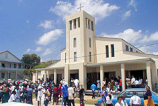
Sacred Heart Church, in Dangriga, Belize, is a Roman Catholic parish.
The Billy Barquedier National Park is a national park in Belize, located between 16.5–19 miles on the Hummingbird Highway in Stann Creek District, south of Belize City. It is located between the Mullins River and Stann Creek watersheds.
Santa Cruz is a village in Stann Creek District, Belize. It is located 24 miles northwest of the Placencia peninsula.
The Coastal Highway is a major highway in eastern Belize. It runs from the George Price Highway in La Democracia, Belize District south to the Hummingbird Highway in Hope Creek, Stann Creek District. This is a distance of 36.17 miles (58.21 km).
This page is based on this Wikipedia article Text is available under the CC BY-SA 4.0 license; additional terms may apply. Images, videos and audio are available under their respective licenses.