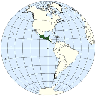
Belize is a country on the north-eastern coast of Central America. It is bordered by Mexico to the north, the Caribbean Sea to the east, and Guatemala to the west and south. It also shares a water boundary with Honduras to the southeast. It has an area of 22,970 square kilometres (8,867 sq mi) and a population of 441,471 (2022). Its mainland is about 290 km (180 mi) long and 110 km (68 mi) wide. It is the least populated and least densely populated country in Central America. Its population growth rate of 1.87% per year is the second-highest in the region and one of the highest in the Western Hemisphere. Its capital is Belmopan, and its largest city is the namesake city of Belize City. Belize is often thought of as a Caribbean country in Central America because it has a history similar to that of English-speaking Caribbean nations. Belize's institutions and official language reflect its history as a British colony.

Belize is a small Central American nation, located at 17°15' north of the equator and 88°45' west of the Prime Meridian on the Yucatán Peninsula. It borders the Caribbean Sea to the east, with 386 km of coastline. It has a total of 542 km of land borders—Mexico to the north-northwest (272 km) and Guatemala to the south-southwest (266 km). Belize's total size is 22,966 km2 (8,867 sq mi), of which 22,806 km2 (8,805 sq mi) is land and 160 km2 (62 sq mi) is water.
The Gulf or Bay of Honduras is a large inlet of the Caribbean Sea, indenting the coasts of Belize, Guatemala, and Honduras. From north to south, it runs for approximately 200 km from Dangriga, Belize, to La Ceiba, Honduras.
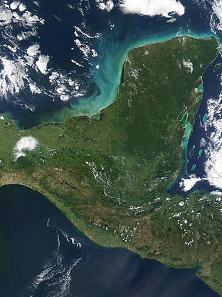
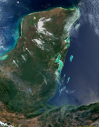
The Yucatán Peninsula is a large peninsula in southeast Mexico and adjacent portions of Belize and Guatemala. The peninsula extends towards the northeast, separating the Gulf of Mexico to the north and west of the peninsula from the Caribbean Sea to the east. The Yucatán Channel, between the northeastern corner of the peninsula and Cuba, connects the two bodies of water.
The geography of Mesoamerica describes the geographic features of Mesoamerica, a culture area in the Americas inhabited by complex indigenous pre-Columbian cultures exhibiting a suite of shared and common cultural characteristics. Several well-known Mesoamerican cultures include the Olmec, Teotihuacan, the Maya, the Aztec and the Purépecha. Mesoamerica is often subdivided in a number of ways. One common method, albeit a broad and general classification, is to distinguish between the highlands and lowlands. Another way is to subdivide the region into sub-areas that generally correlate to either culture areas or specific physiographic regions.
The Sarstoon River is a Central American river that forms part of the international border between Belize and Guatemala.

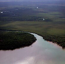
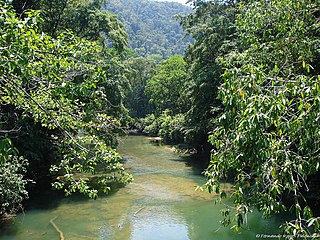
The Mopan River is a river in Central America spanning the Petén Department of Guatemala and the Cayo District of Belize. It merges with the Macal River at Branch Mouth, Belize, forming the Belize River, which ultimately discharges into the Caribbean Sea. The drainage area of the combined watershed is 9,434.2 km2 (3,642.6 sq mi). Tributaries of the Mopan include Chiquibul Branch, Ceiba Grande, Salisipuedes, and Delores.

The Petén–Veracruz moist forests is an ecoregion of the tropical and subtropical moist broadleaf forest biome found in Belize, Guatemala, and Mexico.

The Belizean–Guatemalan territorial dispute is an unresolved territorial dispute between the states of Belize and Guatemala, neighbours in Central America. During the late 1600s and throughout the 1700s, Britain and Spain signed several treaties regarding territories in the Americas. Both nations agreed that the territory of modern-day Belize was under Spanish sovereignty, but British settlers could use the land, in specific areas and for specific purposes. However, the area was never fully under British or Spanish rule at this time and the British settlers continually expanded far past the boundaries set by the treaties. When the Spanish Empire fell, Guatemala said that it inherited Spain's sovereign rights over the territory. Since independence, Guatemala has claimed, in whole or in part, the territory of Belize.
The Central America bioregion is a biogeographic region comprising southern Mexico and Central America.
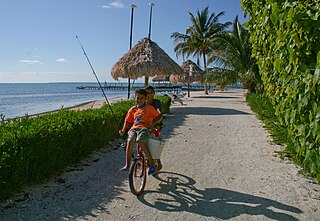
Belizeans are people associated with the country of Belize through citizenship or descent. Belize is a multiethnic country with residents of Ethnic groups of Amerindian, African, European, Asian and Middle-eastern descent or mixed race with any combination of those groups.

Xibun is an alternate Mayan spelling of Sibun that appears on some Spanish colonial-period maps of the region, and is sometimes used to refer to:
Hispanic and Latin American Belizeans are Belizeans of full or partial Hispanic and Latin American descent. Currently, they comprise around 52.9% of Belize's population.
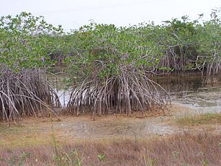
The Belizean Coast mangroves ecoregion covers the brackish and salt-water habitats along the Caribbean Sea coast of Belize, and of Amatique Bay in Guatemala; small parts in the border with Mexico are also present on this ecoregion. The mangroves are partially protected from the open sea by the Belize Barrier Reef, and this ecoregion is distinct from the reef-based Belizean Reef mangroves ecoregion offshore. There is a large population of the vulnerable West Indian manatee in the area. It covers an area of around 2850 km2.

Pacbitun is a Maya archaeological site located near the town of San Ignacio, Belize, in the Cayo District of west central Belize. The modern Maya name given to the site means “stone set in earth”, likely a reference to multiple fragments of stone monuments. The site, at about 240 m above sea level, is one of the earliest known from the southern Maya Lowlands, and was inhabited for almost 2000 years, from ca. 900 BCE to 900 CE. Strategically, it straddles a territory of rolling, hilly terrain between the Mountain Pine Ridge and the tropical forest covered lowlands of the Upper Belize River Valley.
Belizean Spanish is the dialect of Spanish spoken in Belize. It is similar to Caribbean Spanish, Andalusian Spanish, and Canarian Spanish. While English is the only official language of Belize, Spanish is the common language of majority (62.8%), wherein 174,000 speak some variety of Spanish as a native language. Belizeans of Guatemalan, Honduran, Mexican, Nicaraguan, Salvadoran, and even Cuban descent may speak different dialects of Spanish, but since they grow up in Belize, they adopt the local accent.

The Archaic period, also known as the preceramic period, is a period in Mesoamerican chronology that begins around 8000 BCE and ends around 2000 BCE and is generally divided into Early, Middle, and Late Archaic periods. The period is preceded by the Paleoindian period and followed by the Preclassic period. Scholars have found it difficult to determine exactly when the Paleoindian period ends and the Archaic begins, but it is generally linked with changing climate associated with the transition from the Pleistocene to the Holocene epochs, and absence of extinct Pleistocene animals. It is also generally unclear when the Archaic period ends and the Preclassic period begins, though the appearance of pottery, large-scale agriculture, and villages signal the transition.
The Archaic period is traditionally viewed as a long, transitional interval between the hunter-gatherers of the Paleoindian period and the proliferation of agricultural villages in the Preclassic. This period is known for the domestication of major Mesoamerican crops, the development of agriculture, and the beginning of sedentism. The major developments in agriculture and sedentism during this time allowed for the rise of complex societies in the region. These developments were not uniform throughout Mesoamerica and often differed regionally.

Dzuluinicob, or the Province of Dzuluinicob or Ts'ulwinikob, was a Postclassic Maya state in the Yucatán Peninsula of the Maya Lowlands.