
Belize is a country on the north-eastern coast of Central America. It is bordered by Mexico to the north, the Caribbean Sea to the east, and Guatemala to the west and south. It also shares a water boundary with Honduras to the southeast. It has an area of 22,970 square kilometres (8,867 sq mi) and a population of 441,471 (2022). Its mainland is about 290 km (180 mi) long and 110 km (68 mi) wide. It is the least populated and least densely populated country in Central America. Its population growth rate of 1.87% per year is the second-highest in the region and one of the highest in the Western Hemisphere. Its capital is Belmopan, and its largest city is the namesake city of Belize City. Belize is often thought of as a Caribbean country in Central America because it has a history similar to that of English-speaking Caribbean nations. Belize's institutions and official language reflect its history as a British colony.

Demographics of the population of Belize include population density, ethnicity, education level, health of the populace, economic status, religious affiliations and other aspects.

Dangriga, formerly known as Stann Creek Town, is a town in southern Belize, located on the Caribbean coast at the mouth of the North Stann Creek River. It is the capital of Belize's Stann Creek District. Dangriga is served by the Dangriga Airport. Commonly known as the "culture capital of Belize" due to its influence on punta music and other forms of Garifuna culture, Dangriga is the largest settlement in southern Belize.

Benque Viejo del Carmen ("Benque") is the westernmost town in Belize, 130 km (81 mi) by road west and south of Belize City, at the Guatemalan border. San Ignacio lies 13 km to the east and Melchor de Mencos just across the border. The Mopan River runs along the town's north and west edges.

Stann Creek District is a district in the south east region of Belize. According to the 2010 census, the district had a population of 32,166 people. Its capital is the town of Dangriga, formerly known as "Stann Creek Town." Stann comes from "stanns," or safe havens used by colonialists coming from the "old world" to the "new world."
Cayo District is a district located in the west part of Belize. It is the most extensive, second-most populous and third-most densely populated of the six districts of Belize. The district's capital is the town of San Ignacio.
The Roman Catholic Diocese of Belize City–Belmopan is a diocese of the Latin Church of the Roman Catholic Church in continental Central America. The diocese comprises the entirety of Belize, the former British dependency British Honduras. It is a Latin suffragan of the Archdiocese of Kingston and a member of the Antilles Episcopal Conference, yet still depends on the missionary Roman Congregation for the Evangelization of Peoples.

Belize's 6 districts are politically divided into 31 constituencies. Each constituency sends one representative to Belize's House of Representatives for 5-year terms. This election is known as the General Election. Each person votes for the candidate they would want to represent their constituency in Central Government.
Belize, on the east coast of Central America, southeast of Mexico, was inhabited by the indigenous peoples who fought off the Spaniards in an attempt to preserve their heritage and to avoid the fate of their neighbors who were conquered and under Spanish rule. While this was going on, British pirates would rob Spanish merchant ships and navigate through the shallow waters and small islands even going up river later to hide their bounty. The indigenous people of Belize did not resist the British like they did the Spanish. In the 17th century, however, the British settlement became a formal British crown colony from 1862 through 1964, where they first achieved self government and later in 1981 became an independent country recognized globally with all its territory intact. The British brought along with them slaves taken from Congo and Angola during the eighteenth century.
The history of Belize dates back thousands of years. The Maya civilization spread into the area of Belize between 1500 BC to 1200 BC and flourished until about 1000 AD. Several Maya ruin sites, including Cahal Pech, Caracol, Lamanai, Lubaantun, Altun Ha, and Xunantunich reflect the advanced civilization and much denser population of that period. The first recorded European incursions in the region were made by Spanish conquistadors and missionaries in the 16th century. One attraction of the area was the availability of logwood, which also brought British settlers.
Belizeans are people associated with the country of Belize through citizenship or descent. Belize is a multiethnic country with residents of African, Amerindian, European and Asian descent or any combination of those groups.
Holy Redeemer Cathedral is a Roman Catholic cathedral in the city of Belize City, Belize. It is canonically the mother church of the Roman Catholic Diocese of Belize City-Belmopan. It shares the role with Our Lady of Guadalupe Co-Cathedral in Belmopan, though the Bishop's offices remain at Holy Redeemer. Pope John Paul II made the first Papal visit to Belize and visited the cathedral in 1983.
Burrell Boom is on the Belize River twenty miles above Belize City, Belize. Tourists pass through this historic village on their way to the Community Baboon Sanctuary, where the population of black howler monkeys has grown to over 2,000.

San Antonio is a village in the Toledo District of Belize. It is the largest Maya settlement in Belize, with a population of approximately 1,000 people, predominantly Mopan Maya. About 88% of the inhabitants are Catholic, with 8% belonging to other Christian denominations, and 4% being non-denominational. Along with 29 other mission parishes in the Toledo District, it is pastored by Jesuits from St. Peter Claver church in Punta Gorda.

Salvatore di Pietro, was an Italian Bishop in the Catholic Church. He served as the first Vicar Apostolic of Belize from 1893-1898. He is widely regarded as the most important figure in consolidating the Catholic presence in Belize in the second half of the 19th century.
This history of the Catholic church in Belize has three parts: the historical periods of the Catholic presence in Belize, religious congregations laboring in Belize, and apostolic works undertaken.
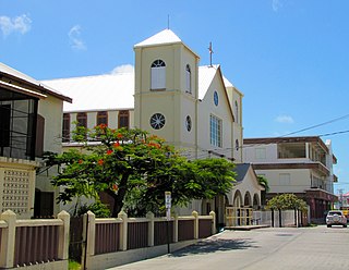
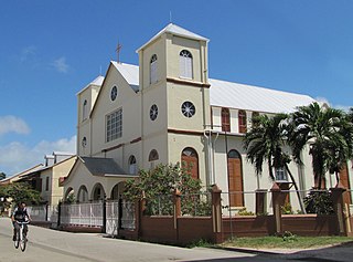
Sacred Heart Church, in Dangriga, Belize, is a Roman Catholic parish.
When the Holy Redeemer Catholic parish was founded in 1852, it was the only parish in Belize and from it missionaries covered the whole country. When other parishes were founded Holy Redeemer remained a parish with its own history but with its leadership connected to the Catholic church in all of Belize under titles of governance that evolved over the years from apostolic prefect to apostolic vicar to bishop. It has remained the hub of the diocese, the bishop's church, as well as a parish in its own right.
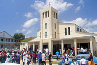
St. Peter Claver Catholic parish is located in Punta Gorda, Toledo District, Belize.
