Related Research Articles
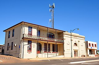
The District Council of Streaky Bay is a local government area in South Australia located on the Eyre Peninsula. Streaky Bay is the main population centre of about 1,200 people serving an agricultural district based on farming wheat and other cereal crops, sheep, supplemented by fishing and tourism industries. The district covers an area of 6,251.1 square kilometres with a population of 2,074 people in 2016, according to the Australian Bureau of Statistics. Mayor of Streaky Bay is Travis Barber.

The County of Hindmarsh is one of the 49 cadastral counties of South Australia. It was proclaimed by Governor George Grey in 1842 and named for Governor John Hindmarsh.
The County of Dufferin is one of the 49 counties of South Australia on the state's west coast. It was proclaimed in 1889 and named for Frederick, Lord Dufferin, a prominent British diplomat of the day.

County of Fergusson is a cadastral unit located in the Australian state of South Australia which spans Yorke Peninsula south of Price. It was proclaimed in 1869 by Governor Fergusson after whom the county was named.

County of Young is a cadastral unit located in the Australian state of South Australia covers land located in the state’s east on the north side of the Murray River. It was proclaimed in 1860 by Governor MacDonnell and named after his predecessor, Governor Young. It has been partially divided in the following sub-units of hundreds – Markaranka, Parcoola, Pooginook and Stuart.

County of Buxton is a cadastral unit located in the Australian state of South Australia that covers land located in the centre of Eyre Peninsula. It was proclaimed in 1896 and named after Thomas Buxton who was the Governor of South Australia from 29 October 1895 to 29 March 1899. It has been divided into thirteen sub-divisions known as hundreds, with the most recent being created in 1928.
The Hundred of Cotton is a hundred in the County of Chandos, South Australia, established in 1894.

The Hundred of Bews is a hundred in the County of Chandos, South Australia, established in 1894.
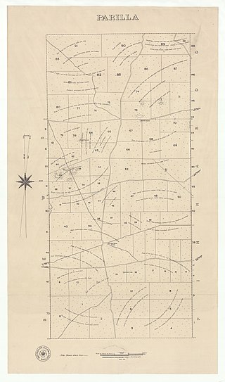
The Hundred of Parilla is a hundred within the County of Chandos, South Australia. It was established in 1894.
Peeninga is a hundred within the County of Chandos, South Australia established in 1912.
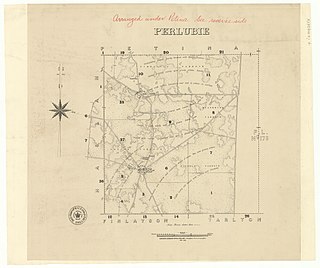
The Hundred of Perlubie is a hundred within County of Dufferin, South Australia and was proclaimed in 1895.
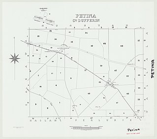
The Hundred of Petina is a hundred within County of Dufferin, South Australia and was proclaimed in 1893.

The Hundred of Nunnyah is a hundred within County of Dufferin, South Australia. and was founded in 1913.

The Hundred of Louth is a hundred within County of Flinders, South Australia. It is on the Eyre Peninsula and was proclaimed in 1857.

The Hundred of Stokes is a hundred in the County of Flinders, South Australia. It was proclaimed on 21 November 1878. The name is derived from Francis William Stokes, a member of the South Australian Parliament. Its extent includes the entirety of Cockaleechie in the northwest, part of Ungarra in the northeast, part of Tumby Bay in the southeast and the northern end of Yallunda Flat in the southwest.
The Hundred of Wallala is a cadastral unit of hundred in the County of Dufferin, South Australia.
Yantanabie is a town and rural locality in the wheat belt of South Australia, 37 miles inland from Streaky Bay, South Australia.

County of Blachford is a cadastral unit located in the Australian state of South Australia that covers land between the east coast of Lake Torrens and the western side of the Flinders Ranges about 90 kilometres (56 mi) north-east of the city of Port Augusta. It was proclaimed in 1877 and named after Frederic Rogers, 1st Baron Blachford who was the Under Secretary of State for the Colonies from 1860 to 1871. It has been partially divided in the following sub-units of hundreds – Barndioota, Cotabena, Warrakimbo, Wonoka and Woolyana.

County of Herbert is a cadastral unit located in the Australian state of South Australia that covers land to the east of the Flinders Ranges about 55 kilometres (34 mi) north-east of the town of Peterborough. It was proclaimed in 1877 and named after a prominent man of the time with either a title or a surname containing the name ‘Herbert’. It has been partially divided in the following sub-units of hundreds – Cavenagh, Coglin, Minburra, Nackara, Paratoo and Waroonee.

County of Kimberley is a cadastral unit located in the Australian state of South Australia that covers land to the east of the Flinders Ranges about 45 kilometres (28 mi) east of the town of Peterborough. It was proclaimed in 1871 and named after John Wodehouse, 1st Earl of Kimberley, a British Secretary of State for the Colonies. It has been partially divided in the following sub-units of hundreds – Gumbowie, Hardy, Ketchowla, Parnaroo, Terowie and Wonna.
References
- ↑ The Fleurieu Peninsula Family History Group Inc. of South Australia, The Counties & Hundreds of South Australia.
- ↑ Leadbeater, Maureen M (5 June 2016). "Counties and Hundreds – South Australia". FamilyHistorySA.info. Retrieved 19 July 2016.
- ↑ "HUNDRED MAP Series Index Map" (PDF). Department of Environment and Heritage, Government of South Australia. December 2008. Archived from the original (PDF) on 27 September 2015. Retrieved 16 November 2015.
- ↑ David Horton (ed.),Aboriginal Australia Map (The Encyclopedia of Aboriginal Australia by AIATSIS, 1994)
| | This South Australia geography article is a stub. You can help Wikipedia by expanding it. |