Related Research Articles

The Mid North is a region of South Australia, north of the Adelaide Plains and south of the Far North and the outback. It is generally accepted to extend from Spencer Gulf east to the Barrier Highway, including the coastal plain, the southern part of the Flinders Ranges, and the northern part of the Mount Lofty Ranges. The Temperate Grassland of South Australia cover most of the area.
The Ngadjuri people are a group of Aboriginal Australian people whose traditional lands lie in the mid north of South Australia with a territory extending from Gawler in the south to Orroroo in the Flinders Ranges in the north.

Leasingham is the name of a hamlet on the southern edge of the Clare Valley, in the Mid North of South Australia. It is approximately 117 kilometres from the state's capital, Adelaide and 17 kilometres south of the town of Clare.
The Willochra Plain is a wide plain situated east of Port Augusta, South Australia. The area falls in the view from Mount Brown Lookout and from walking trails in The Dutchmans Stern Conservation Park.
Ngadjuri is an extinct Australian Aboriginal language formerly spoken by the Ngadjuri people of South Australia, whose traditional lands covered roughly 30,000 square kilometres (11,500 sq mi), embracing Angaston and Freeling in the south and running northwards to Clare, Crystal Brook, Gladstone up to Carrieton and Orroroo in the Flinders Ranges.
The District Council of Georgetown was a local government area in South Australia, centred on the town of Georgetown.

County of Burra is a cadastral unit located in the Australian state of South Australia which covers land located in the state’s east associated with the town of Burra. It was proclaimed in 1851 by Governor Young and named after the town of Burra.
Bright is a rural locality in the Mid North region of South Australia, situated in the Regional Council of Goyder. It was established in August 2000, when boundaries were formalised for the "long established local name". It incorporates most of the cadastral Hundred of Bright, which was proclaimed on 17 June 1875 and named for politician Henry Edward Bright.
Koonoona is a rural locality in the Mid North region of South Australia, situated in the Regional Council of Goyder. It was established in August 2000, when boundaries were formalised for the "long established local name". It occupies the north-western corner of the cadastral Hundred of Apoinga.
The Hundred of Boolcunda is a cadastral hundred of the County of Newcastle in South Australia. It was proclaimed by Governor Anthony Musgrave in 1876.
The Hundred of Cudlamudla is a cadastral hundred of the County of Newcastle in South Australia, that is located at 32.195°S 138.215°E. The traditional owners of the area are the Ngadjuri peoples/ and the first European explorer to the area was Thomas Burr in September 1842.
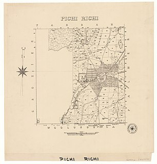
The Hundred of Pichi Richi is a cadastral hundred of the County of Newcastle in South Australia, located at 32.195°S 138.215°E and 293 m (961 ft) above sea level. It spans the eastern slopes of Dutchman Range and is centred on the township of Quorn.
The Hundred of Palmer is a cadastral hundred of the County of Newcastle in South Australia. It is located near 32.195°S, 138.215°E east of the township of Quorn, and south of the former town of Willochra which, although surveyed in 1860, never properly developed and was abandoned during the drought in the 1860s.
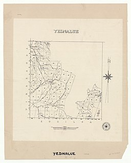
The Hundred of Yednalue is a cadastral unit of hundred in the County of Granville, South Australia.

The Hundred of Wirreanda is a cadastral unit of hundred in the County of Granville, South Australia. The township of Cradock is at the hundred's centre.

County of Taunton is a cadastral unit located in the Australian state of South Australia on land on the east coast of Lake Torrens about 160 kilometres (99 mi) from the city of Port Augusta. It was proclaimed in 1877 and named after Lord Taunton who was the Secretary for the Colonies from 1855 to 1858. It has been partially divided in the following sub-units of hundreds – Bunyeroo, Carr, Edeowie, Nilpena, Oratunga and Parachilna.

County of Blachford is a cadastral unit located in the Australian state of South Australia that covers land between the east coast of Lake Torrens and the western side of the Flinders Ranges about 90 kilometres (56 mi) north-east of the city of Port Augusta. It was proclaimed in 1877 and named after Frederic Rogers, 1st Baron Blachford who was the Under Secretary of State for the Colonies from 1860 to 1871. It has been partially divided in the following sub-units of hundreds – Barndioota, Cotabena, Warrakimbo, Wonoka and Woolyana.

County of Herbert is a cadastral unit located in the Australian state of South Australia that covers land to the east of the Flinders Ranges about 55 kilometres (34 mi) north-east of the town of Peterborough. It was proclaimed in 1877 and named after a prominent man of the time with either a title or a surname containing the name ‘Herbert’. It has been partially divided in the following sub-units of hundreds – Cavenagh, Coglin, Minburra, Nackara, Paratoo and Waroonee.

County of Kimberley is a cadastral unit located in the Australian state of South Australia that covers land to the east of the Flinders Ranges about 45 kilometres (28 mi) east of the town of Peterborough. It was proclaimed in 1871 and named after John Wodehouse, 1st Earl of Kimberley, a British Secretary of State for the Colonies. It has been partially divided in the following sub-units of hundreds – Gumbowie, Hardy, Ketchowla, Parnaroo, Terowie and Wonna.
Mimbara Conservation Park is a protected area in the Australian state of South Australia located in the locality of Worlds End about 147 kilometres (91 mi) north-east of the state capital of Adelaide and about 22 kilometres (14 mi) south-east of the town of Burra.
References
- ↑ "Ngadjuri". AusAnthrop Australian Aboriginal tribal database. Retrieved 16 March 2015.
Coordinates: 32°11′42″S138°12′54″E / 32.195°S 138.215°E
| | This South Australia geography article is a stub. You can help Wikipedia by expanding it. |