
Jackson Lake is in Grand Teton National Park in northwestern Wyoming. This natural lake was enlarged by the construction of the Jackson Lake Dam, which was originally built in 1911, enlarged in 1916 and rebuilt by 1989. The top 33 ft (10 m) of the lake is utilized by farmers in Idaho for irrigation purposes. The lake is the remnant of large glacial gouging from the neighboring Teton Range to the west and the Yellowstone Plateau to the north. The lake is primarily fed by the Snake River, which flows in from the north, and empties at Jackson Lake Dam. Jackson Lake is one of the largest high altitude lakes in the United States, at an elevation of 6,772 ft (2,064 m) above sea level. The lake is up to 15 mi (24 km) long, 7 mi (11 km) wide and 438 ft (134 m) deep. The water of the lake averages below 60 °F (16 °C), even during the summer.
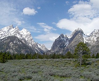
Cascade Canyon is located in Grand Teton National Park, in the U.S. state of Wyoming. The canyon was formed by glaciers which retreated at the end of the last glacial maximum approximately 15,000 years ago. Today, Cascade Canyon has numerous polished glacial erratics, hanging cirques and a U-shape as evidences that demonstrate that glaciers once filled the canyon to a depth of at least 2,000 feet (610 m). Rock debris that was transported out of the canyon by glacial motion formed moraines which now impound the waters of Jenny Lake which is located at the base of the canyon. Cascade Creek now flows where the glaciers once did and the numerous waterfalls, such as the 100-foot (30 m) tall Hidden Falls, found within the gorge are popular destinations with tourists.

Signal Mountain is an isolated summit standing 7,720 feet (2,350 m) above sea level. The mountain is located in Grand Teton National Park in the U.S. state of Wyoming. The next closest higher summit is more than 10 miles (16 km) distant, and this isolation provides sweeping views of the Teton Range, much of the northern Jackson Hole area as well as the Snake River. Though located adjacent to the Tetons, Signal Mountain was not formed in the same manner or period. The mountain originally was formed by volcanic ashfall from one of the eruptions of the Yellowstone hotspot. The peak is also partially a glacial moraine formed by a receding glacier that came south out of the Yellowstone icecap. This same glacier also created neighboring Jackson Lake.

Ranger Peak is in the northern Teton Range, Grand Teton National Park, Wyoming. The peak is located slightly northwest of and across Jackson Lake from Colter Bay Village. Colter Canyon is to the north while Waterfalls Canyon is immediately southeast of the peak, but there are no maintained trails in the area. Access to the summit involves off trail hiking and scrambling. The top of the mountain is more than 4,500 feet (1,400 m) above Jackson Lake.

Rendezvous Mountain is a large mountain massif located in the southern Teton Range in the U.S. state of Wyoming. The highest point on Rendezvous Mountain is Rendezvous Peak. The west and northern flanks of the mountain are in Grand Teton National Park, Wyoming, while much of the remainder of the massif is in Bridger-Teton National Forest. The mountain massif extends for a distance of 5 miles (8.0 km) between Granite Canyon to the north and Phillips Canyon to the south. Though there are numerous summits above 10,000 feet (3,000 m), the one that is most commonly visited is the North Peak, where the Jackson Hole Mountain Resort aerial tram provides access to the summit for skiers in the winter and sightseerings and hikers in the summer. The hike down the Rendezvous Mountain Trail to the Granite Canyon Trail has a descent of 4,100 feet (1,200 m) over 12.3 miles (19.8 km).

The Teton Crest Trail is a 40-mile (64 km) long hiking trail in the U.S. state of Wyoming that extends from Phillips Pass, on the border of Bridger Teton and Caribou-Targhee National Forests, to String Lake in Grand Teton National Park. Backpacker Magazine calls the Trail one of the "Best Hikes Ever," with "mesmerizing and constant views of jagged peaks."

Paintbrush Divide is a pedestrian mountain pass located in the Teton Range, Grand Teton National Park, in the U.S. state of Wyoming. Situated at approximately 10,720 ft (3,270 m) above sea level, the pass can be accessed from the east by way of the Paintbrush Canyon or Cascade Canyon Trails and involves a nearly 4,000 ft (1,200 m) elevation gain.
Moose Basin Divide is a pedestrian mountain pass located in the Teton Range, Grand Teton National Park, in the U.S. state of Wyoming. The divide is situated at 9,718 ft (2,962 m) above sea level and is accessed by way of the Webb Canyon Trail from the south or the Owl Creek Trail from the north. From Wilcox Point on Jackson Lake, Moose Basin Divide is a 9.1 mi (14.6 km) one way trip by way of the Webb Canyon Trail. The divide is located in a less visited region of the park and the trails cross streams that do not have foot bridges.
Mount Meek Pass is a pedestrian mountain pass located in the Teton Range, Grand Teton National Park, in the U.S. state of Wyoming. The pass is situated at 9,718 ft (2,962 m) above sea level and is accessed by way of the Teton Crest Trail and is immediately east of Mount Meek. Mount Meek Pass is more than 12 mi (19 km) from the nearest trailhead. To the south of the pass lies Death Canyon Shelf within Grand Teton National Park, while to the north can be found the region known as Alaska Basin, which is in Caribou-Targhee National Forest.
Fox Creek Pass is a pedestrian mountain pass located in the Teton Range, Grand Teton National Park, in the U.S. state of Wyoming. The pass is situated at 9,570 ft (2,920 m) above sea level and is at the head of Death Canyon. Fox Creek Pass can be accessed by way of the Teton Crest Trail or the Death Canyon Trail from the east. To the north lies the Death Canyon Shelf in Grand Teton National Park while Fossil Mountain and Caribou-Targhee National Forest are to the west and south, respectively.

Static Peak Divide is a pedestrian mountain pass located in the Teton Range, Grand Teton National Park, in the U.S. state of Wyoming. The pass is situated at 10,800 ft (3,300 m) above sea level and is the high point along the Alaska Basin Trail which is accessed from Death Canyon. The Static Peak Divide is the highest altitude mountain pass along any maintained trail in Grand Teton National Park and is just west of Static Peak.
The Webb Canyon Trail is a 9.9-mile (15.9 km) long hiking trail in the far northern region of Grand Teton National Park in the U.S. state of Wyoming. The trail begins near the National Park Service backcountry patrol cabin near Wilcox Point on Jackson Lake. Located in the remote northern backcountry of Grand Teton National Park, the trail is not connected to maintained trails in the southern part of the park and must be accessed from the Glade Creek trailhead in the John D. Rockefeller, Jr. Memorial Parkway. From Glade Creek, it is a 7.5 mi (12.1 km) hike to the patrol cabin and the beginning of the Webb Canyon Trail. The trail follows Moose Creek west and after several miles, is flanked by both Owl Peak and Elk Mountain to the north and several unnamed peaks nearing 11,000 ft (3,400 m) to the south. At Moose Basin Divide the trail meets the Owl Creek Trail.
Jackass Pass is a pedestrian mountain pass located in the Teton Range and on the border of Grand Teton National Park and Bridger-Teton National Forest in the U.S. state of Wyoming. Access to Jackass Pass from Grand Teton National Park involves a 6.7 mi (10.8 km) hike up the Berry Creek Trail or even greater distances if coming from the National Forest side.

The Garnet Canyon Trail is a 4.8-mile (7.7 km) long hiking trail in Grand Teton National Park in the U.S. state of Wyoming. The trailhead is at the Lupine Meadows parking area and climbs steeply more than 2,500 feet (760 m) in just under 5 miles (8.0 km) into Garnet Canyon. At the 2-mile (3.2 km) point, the trail forks from the Amphitheater Lake Trail and heads south and then west into Garnet Canyon. Garnet Canyon is the most popular approach route for climbers attempting to summit not only Grand Teton but also Middle Teton, South Teton, Teepe Pillar and Disappointment Peak. Though the trail becomes unmaintained once it enters boulder fields at approximately the 9,500-foot (2,900 m) elevation point, climbers continue on to other destinations such as the Lower Saddle, a high altitude mountain pass situated between Middle and Grand Teton. The altitude gain from the Lupine Meadows trailhead to the Lower Saddle is nearly 5,000 feet (1,500 m).
The Signal Mountain Trail is a 6.8-mile (10.9 km) long roundtrip hiking trail in Grand Teton National Park in the U.S. state of Wyoming. The trail begins near Signal Mountain Lodge on Jackson Lake and provides hiking access to the summit of Signal Mountain. The trail passes through Lodgepole Pine forests most of the way and the view from the summit of Signal Mountain provide sweeping views of the entire Teton Range and much of Jackson Hole.
Alaska Basin is a subalpine basin on the west slopes of the Teton Range, in the U.S. state of Wyoming. Located on the western border of Grand Teton National Park, Alaska Basin is within the Jedediah Smith Wilderness of Caribou-Targhee National Forest. The drainage for the basin is to the northwest along Teton Creek through Teton Canyon. Access into the basin is by trail only and the basin is bisected by the Teton Crest Trail which connects Mount Meek Pass to the south with Hurricane Pass to the north. The Alaska Basin Trail also enters Alaska Basin and connects with the Teton Crest Trail near Sunset Lake. Alaska Basin can also be accessed from the west by starting at the Teton Canyon campground. From there the hike to the summit of Table Mountain is 12 miles (19 km) roundtrip with a total elevation gain of 4,150 feet (1,260 m).
The Cascade Canyon Trail is a 13.6-mile (21.9 km) round-trip long hiking trail in Grand Teton National Park in the U.S. state of Wyoming. The trailhead is at the South Jenny Lake parking area and follows the Jenny Lake Trail around the south shore of Jenny Lake to the Forks of Cascade Canyon. The trail passes near Hidden Falls after almost 3 miles (4.8 km) then goes west into the heart of Cascade Canyon, flanked by Teewinot Mountain and Mount Owen to the south and The Jaw and Rock of Ages to the north. At the Forks of Cascade Canyon, the trail splits with the Lake Solitude Trail heading to Lake Solitude and Paintbrush Divide, while the South Fork Cascade Canyon Trail leads to Hurricane Pass. There are no camping areas along the trail though not far from the Forks, camping zones exist to the north and south. At South Jenny Lake, a boat shuttle operates during the summer which shortens the hike by 4 miles (6.4 km).

The South Fork Cascade Canyon Trail is a 5.6-mile (9.0 km) long hiking trail in Grand Teton National Park in the U.S. state of Wyoming. The trail begins at the Forks of Cascade Canyon and extends to Hurricane Pass. A short connector trail just before Hurricane Pass leads to Schoolroom Glacier. From the Forks of Cascade Canyon and most of the way through South Cascade Canyon, backcountry camping is allowed with a permit. The South Fork Cascade Canyon Trail is also part of the Teton Crest Trail its entire length and to the south beyond Hurricane Pass lies Alaska Basin.


