Caribou-Targhee National Forest

Last updated
Caribou-Targhee National Forest

Teton Range from Caribou NF.JPG

Camas flowers and the west vista of the Teton Range from Caribou-Targhee National Forest
Usa edcp relief location map.png
Red pog.svg
Location Idaho-Wyoming-Utah, United States
Nearest city Pocatello, ID
Coordinates 42°47′0″N111°33′0″W / 42.78333°N 111.55000°W / 42.78333; -111.55000 Coordinates: 42°47′0″N111°33′0″W / 42.78333°N 111.55000°W / 42.78333; -111.55000
Area 2,630,716 acres (10,646.13 km2) [1]
Established 1903
Governing body U.S. Forest Service
Website Caribou-Targhee National Forest

Caribou-Targhee National Forest is located in the states of Idaho and Wyoming, with a small section in Utah in the United States. The forest is broken into several separate sections and extends over 2.63 million acres (10,600 km2). To the east the forest borders Yellowstone National Park, Grand Teton National Park and Bridger-Teton National Forest. Most of the forest is a part of the 20-million-acre (81,000 km2) Greater Yellowstone Ecosystem.

Idaho State of the United States of America

Idaho is a state in the northwestern region of the United States. It borders the state of Montana to the east and northeast, Wyoming to the east, Nevada and Utah to the south, and Washington and Oregon to the west. To the north, it shares a small portion of the Canadian border with the province of British Columbia. With a population of approximately 1.7 million and an area of 83,569 square miles (216,440 km2), Idaho is the 14th largest, the 12th least populous and the 7th least densely populated of the 50 U.S. states. The state's capital and largest city is Boise.

Wyoming State of the United States of America

Wyoming is a state in the mountain region of the western United States. The state is the 10th largest by area, the least populous, and the second most sparsely populated state in the country. Wyoming is bordered on the north by Montana, on the east by South Dakota and Nebraska, on the south by Colorado, on the southwest by Utah, and on the west by Idaho and Montana. The state population was estimated at 577,737 in 2018, which is less than 31 of the most populous U.S. cities including neighboring Denver. Cheyenne is the state capital and the most populous city, with an estimated population of 63,624 in 2017.

Utah A state of the United States of America

Utah is a state in the western United States. It became the 45th state admitted to the U.S. on January 4, 1896. Utah is the 13th-largest by area, 31st-most-populous, and 10th-least-densely populated of the 50 United States. Utah has a population of more than 3 million according to the Census estimate for July 1, 2016. Urban development is mostly concentrated in two areas: the Wasatch Front in the north-central part of the state, which contains approximately 2.5 million people; and Washington County in Southern Utah, with over 160,000 residents. Utah is bordered by Colorado to the east, Wyoming to the northeast, Idaho to the north, Arizona to the south, and Nevada to the west. It also touches a corner of New Mexico in the southeast.

Contents

Description

Caribou and Targhee National Forests were combined from original forest lands created in 1891. Two designated wilderness areas are located in the easternmost sections of the forest, bordering on National Park lands. The 123,451-acre (500 km2) Jedediah Smith Wilderness is adjacent to Grand Teton National Park on the western slope of the Teton Range. Known for karst limestone formations, the wilderness has many caves and provides excellent views of the less often seen west face of the Teton peaks. The smaller 10,715-acre (43 km2) Winegar Hole Wilderness borders Yellowstone National Park and the John D. Rockefeller, Jr. Memorial Parkway, and was set aside primarily to protect prime grizzly bear habitat.

Wilderness undisturbed natural environment

Wilderness or wildland is a natural environment on Earth that has not been significantly modified by human activity. It may also be defined as: "The most intact, undisturbed wild natural areas left on our planet—those last truly wild places that humans do not control and have not developed with roads, pipelines or other industrial infrastructure." The term has traditionally referred to terrestrial environments, though growing attention is being placed on marine wilderness. Recent maps of wilderness suggest it covers roughly one quarter of Earth's terrestrial surface, but is being rapidly degraded by human activity. Even less wilderness remains in the ocean, with only 13.2% free from intense human activity.

Jedediah Smith Wilderness

The Jedediah Smith Wilderness is located in the U.S. state of Wyoming. Designated wilderness by Congress in 1984, Jedediah Smith Wilderness is within Caribou-Targhee National Forest and borders Grand Teton National Park. Spanning along the western slopes of the Teton Range, the wilderness ensures a high level of protection to this delicate ecosystem. Jedediah Smith Wilderness is an integral part of the Greater Yellowstone Ecosystem.

Teton Range mountain range of the Rocky Mountains in North America

The Teton Range is a mountain range of the Rocky Mountains in North America. It extends for approximately 40 miles (64 km) in a north–south direction through the U.S. state of Wyoming, east of the Idaho state line. It is south of Yellowstone National Park and most of the east side of the range is within Grand Teton National Park.

While western sections of the forest have a mixture of sagebrush and grasses, the higher elevations in the east support lodgepole pine, and numerous species of spruce and fir. In addition to grizzlies most of the major megafauna associated with Yellowstone National Park can be found in Caribou-Targhee National Forest. Mammalian species of black bear, wolf, elk, moose, mule deer, bison, cougar, and pronghorn have all been seen by visitors on forest lands. An active peregrine falcon recovery program was begun to return this bird species to some of their ancestral range. Cutthroat trout, brook trout and pike are found in the streams and lakes and the forest is considered one of the best fishing areas in the world for cutthroat trout.

Sagebrush

Sagebrush is the common name of several woody and herbaceus species of plants in the genus Artemisia. The best known sagebrush is the shrub Artemisia tridentata. Sagebrushes are native to the North American west.

Spruce genus of plants

A spruce is a tree of the genus Picea, a genus of about 35 species of coniferous evergreen trees in the family Pinaceae, found in the northern temperate and boreal (taiga) regions of the Earth. Spruces are large trees, from about 20–60 m tall when mature, and have whorled branches and conical form. They can be distinguished from other members of the pine family by their needles (leaves), which are four-sided and attached singly to small persistent peg-like structures (pulvini) on the branches, and by their cones, which hang downwards after they are pollinated. The needles are shed when 4–10 years old, leaving the branches rough with the retained pegs. In other similar genera, the branches are fairly smooth.

Fir genus of plants

Firs (Abies) are a genus of 48–56 species of evergreen coniferous trees in the family Pinaceae. They are found through much of North and Central America, Europe, Asia, and North Africa, occurring in mountains over most of the range. Firs are most closely related to the genus Cedrus (cedar). Douglas firs are not true firs, being of the genus Pseudotsuga.

Minnetonka Cave is one of only two caves administered by the U.S. Forest Service Minnetonka Cave.JPG
Minnetonka Cave is one of only two caves administered by the U.S. Forest Service

Dozens of campgrounds and 1,600 miles (2,500 km) of trails allow access to much of the forest. There are two trails that access the high altitude Alaska Basin immediately west of the main Teton Range peaks and allow access to trails in Grand Teton National Park.

Trail path with a rough beaten or dirt/stone surface used for travel

A trail is usually a path, track or unpaved lane or road. In the United Kingdom and the Republic of Ireland path or footpath is the preferred term for a walking trail. The term is also applied, in North America, to routes along rivers, and sometimes to highways. In the US, the term was historically used for a route into or through wild territory used by emigrants. In the USA "trace" is a synonym for trail, as in Natchez Trace. Some trails are single use and can only be used for walking, cycling, horse riding, snowshoeing, and cross-country skiing; others, as in the case of a bridleway in the UK, are multi-use, and can be used by walkers, cyclists and equestrians. There are also unpaved trails used by dirt bikes and other off-road vehicles and in some places, like the Alps, trails are used for moving cattle and other livestock.

Caribou National Forest, the smaller and more southerly of the two, is located in southeastern Idaho, western Wyoming, and northern Utah, and has a total area of 987,221 acres (399,514 ha). There are local ranger district offices located in Malad City, Montpelier, Pocatello, and Soda Springs in Idaho.

Malad City, Idaho City in Idaho, United States

Malad City is the only city in Oneida County, Idaho, United States. Its population was 2,095 at the 2010 census, down from 2,158 in 2000.

Montpelier, Idaho City in Idaho, United States

Montpelier is a city in Bear Lake County, Idaho, United States. The population was 2,597 at the 2010 census, down from 2,785 in 2000. The city is the largest community in the Bear Lake Valley, a farming region north of Bear Lake in southeastern Idaho along the Utah border. It was settled in 1863 by Mormon pioneers on the route of the Oregon Trail. Nearby to the east is the border with Wyoming.

Pocatello, Idaho City in Idaho, United States

Pocatello is the county seat and largest city of Bannock County, with a small portion on the Fort Hall Indian Reservation in neighboring Power County, in the southeastern part of the U.S. state of Idaho. It is the principal city of the Pocatello metropolitan area, which encompasses all of Bannock county. As of the 2010 census the population of Pocatello was 54,255.

The larger and more northerly Targhee National Forest is located in eastern Idaho and northwestern Wyoming, and has an area of 1,643,501 acres (665,101 ha). [2] There are local ranger district offices located in Ashton, Driggs, Dubois, and Island Park in Idaho. In Island Park is Big Springs (Idaho), a first-magnitude spring that is the source of the South Fork of Henrys Fork.

Ashton, Idaho City in Idaho, United States

Ashton is a city in Fremont County, Idaho, United States. The population was 1,127 at the 2010 census, and it is part of the Rexburg Micropolitan Statistical Area. The district is noted for seed potato production and bills itself as the world's largest seed potato growing area.

Driggs, Idaho City in Idaho, United States

Driggs is a city in Teton County, Idaho, United States. It is part of the Jackson, WY-ID Micropolitan Statistical Area, and is located in Teton Valley, the headwaters of the Teton River. The population was 1,660 at the 2010 census, up from 1,100 in 2000. The city is the county seat of Teton County.

Dubois, Idaho City in Idaho, United States

Dubois is a city in Clark County, Idaho, United States. The population was 677 at the 2010 census. The city is the county seat of Clark County.

Linkage of limited habitat, through ecological corridors, is the current, most favored, method of effectively restoring native wildlife communities. Many such corridors have been identified where wildlife conservation is a concern. The montane nature of the Caribou National Forest and its juxtaposition make it a very important, fragile and unique link between the northern and southern Rocky Mountains. If restoration of native species is to be achieved throughout the wildlands of the American West, the Caribou will play an important role.

The combined Caribou-Targhee National Forest is managed by the Forest Service from offices in Idaho Falls, Idaho.

Wilderness areas

There are two officially designated wilderness areas within the Caribou-Targhee National Forest that are part of the National Wilderness Preservation System. Both lie just south of Yellowstone National Park, in the Targhee National Forest section.

Counties

Counties are listed in descending order of forestland area, by forest.

Caribou National Forest

Targhee National Forest

Upper Mesa Falls, Fremont County, Targhee National Forest A373, Upper Mesa Falls, Caribou-Targhee National Forest, Idaho, USA, 2004.JPG
Upper Mesa Falls, Fremont County, Targhee National Forest

Related Research Articles

Teton River (Idaho) river in the United States of America

The Teton River is an 64-mile-long (103 km) tributary of the Henrys Fork of the Snake River in southeastern Idaho in the United States. It drains through the Teton Valley along the west side of the Teton Range along the Idaho-Wyoming border at the eastern end of the Snake River Plain. Its location along the western flank of the Tetons provides the river with more rainfall than many other rivers of the region.

Henrys Lake lake of the United States of America

Henrys Lake is a small, shallow alpine lake, approximately 8 square miles (21 km2) in area, at 4 miles (6.4 km) in length and 2 miles (3.2 km) in width. It is located at 6,472 ft (1,973 m) above sea level in the mountains of southeastern Idaho in the United States. It is on the southwest side of the Henrys Lake Mountains of northern Fremont County, approximately 2 miles south of the continental divide along the Montana state line, just west of Targhee Pass and north of Sawtell Peak. The lake provides the headwaters of the Henrys Fork, a tributary of the Snake River. The lake lies less than 10 miles (16 km) across the continental divide from the headwaters of the Missouri River in southwestern Montana. It is 16 miles due west of the western boundary of Yellowstone National Park. The lake is located in Caribou-Targhee National Forest.

John D. Rockefeller Jr. Memorial Parkway protected area

John D. Rockefeller Jr. Memorial Parkway is a scenic road that connects Grand Teton National Park and Yellowstone National Park in the U.S. state of Wyoming. It is federally owned and managed by the National Park Service. It is named in remembrance of John D. Rockefeller Jr., a conservationist and philanthropist who was instrumental in the creation and enlargement of numerous national parks including Grand Teton, Virgin Islands, Acadia and the Great Smoky Mountains.

Bridger-Teton National Forest

Bridger-Teton National Forest is located in western Wyoming, United States. The forest consists of 3.4 million acres (14,000 km2), making it the third largest National Forest outside Alaska. The forest stretches from Yellowstone National Park, along the eastern boundary of Grand Teton National Park and from there rides along the western slope of the Continental Divide to the southern end of the Wind River Range. The forest also extends southward encompassing the Salt River Range and Wyoming Range mountains near the Idaho border.

Teton Wilderness

Teton Wilderness is located in Wyoming, United States. Created in 1964, the Teton Wilderness is located within Bridger-Teton National Forest and consists of 585,238 acres (2,370 km2). The wilderness is bordered on the north by Yellowstone National Park and to the west by Grand Teton National Park and the John D. Rockefeller, Jr. Memorial Parkway. The Washakie Wilderness is to the east and the remainder of Bridger-Teton National Forest is to the south. The Teton Wilderness is a part of the 20 million acre (81,000 km2) Greater Yellowstone Ecosystem. Among many other features, Teton Wilderness is notable for having the most remote location of any place in the contiguous 48 states of the US. This location occurs very close to Bridger Lake, near the confluence of the Thorofare and Yellowstone Rivers, not far from the USFS Hawk's Rest Ranger Station.

Winegar Hole Wilderness

The Winegar Hole Wilderness is located in the U.S. state of Wyoming. Designated wilderness by Congress in 1984, the wilderness is within Caribou-Targhee National Forest and borders Yellowstone National Park. The wilderness was created to further protect what is considered to be prime grizzly bear habitat. The wilderness is an integral part of the Greater Yellowstone Ecosystem.

Wasatch-Cache National Forest national forest in Idaho, Utah, and Wyoming in the United States

Wasatch-Cache National Forest is a United States National Forest located primarily in northern Utah (81.23%), with smaller parts extending into southeastern Idaho (16.42%) and southwestern Wyoming (2.35%). The name is derived from the Ute word Wasatch for a low place in high mountains, and the French word Cache meaning to hide. The term cache originally referred to fur trappers, the first Europeans to visit the land. The Wasatch-Cache National Forest boundaries include 1,607,177 acres (6,504.01 km2) of land.

Buck Mountain (Wyoming) mountain in Wyoming

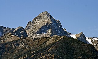
Buck Mountain 11,943 feet (3,640 m) is located in the Teton Range, Grand Teton National Park, Wyoming, immediately southeast of Grand Teton. The mountain is the highest summit south of Garnet Canyon and is easily seen from most vantage points in Jackson Hole. Views from the summit offer excellent views of the Cathedral Group to the north. The west slope of the summit tower are along the Alaska Basin Trail and extend into Caribou-Targhee National Forest and the Jedediah Smith Wilderness, which is the location of Alaska Basin, a popular wilderness camping area for backpackers. Timberline Lake is located on the eastern flanks of the peak.

U.S. Sheep Experiment Station

The U.S. Sheep Experiment Station (USSES) is an agricultural experiment station focusing on domestic sheep which is run by the United States Department of Agriculture's Agricultural Research Service. Its stated mission is "...to develop integrated methods for increasing production efficiency of sheep and to simultaneously improve the sustainability of rangeland ecosystems".

Survey Peak mountain in United States of America

Survey Peak is located in the northern Teton Range in the U.S. state of Wyoming. The peak is on the border of Grand Teton National Park and the Jedediah Smith Wilderness of Caribou-Targhee National Forest. Survey Peak rises to the immediate north of Berry Creek and can be accessed via the Berry Creek Trail.

Red Mountain (Wyoming) mountain in Wyoming, USA

Red Mountain is located in the northern Teton Range in the U.S. state of Wyoming. The peak is on the border of Grand Teton National Park and the Jedediah Smith Wilderness of Caribou-Targhee National Forest.

Moose Mountain (Wyoming) mountain in Wyoming, United States of America

Moose Mountain (10,059 feet is located in the northern Teton Range in the U.S. state of Wyoming. The peak is on the border of Grand Teton National Park and the Jedediah Smith Wilderness of Caribou-Targhee National Forest. Moose Mountain is at the western end of Webb Canyon.

Littles Peak mountain in United States of America

Littles Peak (10,717 feet is located in the Teton Range in the U.S. state of Wyoming. The peak is on the border of Grand Teton National Park and the Jedediah Smith Wilderness of Caribou-Targhee National Forest. Littles Peak is at the western end of Leigh Canyon.

Green Lakes Mountain mountain in United States of America

Green Lakes Mountain (10,240 feet is located in the Teton Range in the U.S. state of Wyoming. The peak is on the border of Grand Teton National Park and the Jedediah Smith Wilderness of Caribou-Targhee National Forest. Green Lakes Mountain is at the head of Moran Canyon and 1 mile SSW of Dry Ridge Mountain.

Dry Ridge Mountain mountain in United States of America

Dry Ridge Mountain (10,326 feet is located in the Teton Range in the U.S. state of Wyoming. The peak is on the border of Grand Teton National Park and the Jedediah Smith Wilderness of Caribou-Targhee National Forest. Dry Ridge Mountain is at the head of Moran Canyon and 1 mile NNE of Green Lakes Mountain.

Table Mountain (Wyoming) mountain in Wyoming, United States of America

Table Mountain is located in the Teton Range in the U.S. state of Wyoming. The peak is on the border of Grand Teton National Park and the Jedediah Smith Wilderness of Caribou-Targhee National Forest. Table Mountain is west of the south fork of Cascade Canyon and a little more than 1 mile (1.6 km) north of Hurricane Pass.

The Wall (mountain) mountain in the U.S. state of Wyoming

The Wall is located in the Teton Range in the U.S. state of Wyoming, running for more than 4 miles (6.4 km) along the western border of Grand Teton National Park. The peak is on the border of Grand Teton National Park and the Jedediah Smith Wilderness of Caribou-Targhee National Forest. This high point, near the northern terminus of the cliff, is 1 mile (1.6 km) WSW of South Teton and overlooks Snowdrift Lake.

Mount Jedediah Smith mountain in United States of America

Mount Jedediah Smith (10,615 feet is located in the Teton Range, on the border of Caribou-Targhee National Forest and Grand Teton National Park in the U.S. state of Wyoming. Mount Jedediah Smith is about .53 miles WSW of Mount Meek.

Teton Valley, Idaho Region in Idaho, United States

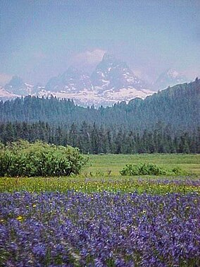
Teton Valley is an area located on the west slope of the Teton Mountain Range and is known as "The quiet side of the Tetons." It is composed of the cities of Victor, Idaho, Driggs, Idaho, Tetonia, Idaho, and Alta, Wyoming. Teton Valley is a rural, agriculture and ranching based economy with a shifting emphasis towards recreational tourism.

References