Huron-Manistee National Forests

Last updated
Huron-Manistee National Forests
IUCN category VI (protected area with sustainable use of natural resources)

Pere Marquette River in Autumn Manistee National Forest.JPG

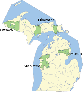
MichiganNationalForests.svg

Map showing National Forests in Michigan.
Location Lower Peninsula, Michigan
Coordinates Huron 44°34′N83°59′W / 44.57°N 83.99°W / 44.57; -83.99
Manistee 43°51′N85°57′W / 43.85°N 85.95°W / 43.85; -85.95
Area Total - 978,906 acres (3,960 km2)
Huron - 438,584 acres (1,770 km2)
Manistee - 540,322 acres (2,190 km2) [1]
Established Huron - 1909
Manistee - 1938
Governing body U.S. Forest Service
Website Huron-Manistee National Forests

The Huron-Manistee National Forests are two separate national forests, the Huron National Forest and the Manistee National Forest, combined in 1945 for administration purposes and which comprise 978,906 acres (3,960 km2) [2] of public lands, including 5,786 acres (23 km2) of wetlands, extending across the northern lower peninsula of Michigan. The Huron-Manistee National Forests provide recreation opportunities for visitors, habitat for fish and wildlife, and resources for local industry. The headquarters for the forests is in Cadillac, Michigan.

United States National Forest classification of federal lands in the United States

National Forest is a classification of protected and managed federal lands in the United States. National Forests are largely forest and woodland areas owned collectively by the American people through the federal government, and managed by the United States Forest Service, a division of the United States Department of Agriculture.

Huron National Forest

The Huron National Forest is a National Forest in the Lower Peninsula of Michigan. It was established in 1909 after the logging era began to decline. In 1945, it was administratively combined with the Manistee National Forest, to create the Huron-Manistee National Forest. However, these are not connected and are separate forests. It provides recreation opportunities for visitors, habitat for fish and wildlife, and resources for local industry. The headquarters for the forest is located in Cadillac, Michigan.

Manistee National Forest

The Manistee National Forest is a national forest located in the Lower Peninsula of Michigan. It has a total area of 540,187 acres (2,190 km2). It was established in 1938, and combined with the Huron National Forest in 1945 for administrative purposes, creating the Huron-Manistee National Forests. However, they are two separate forest units, as they are not connected. The area is popular for hiking, fishing, camping, boating, snowmobiling, cross-country skiing and hunting. The North Country Trail passes through it, and connects with the 11-mile Manistee River Trail to form a 23-mile loop. The highest point in the lower peninsula, Briar Hill, is located here. The Manistee National Forest is not one continuous mass, but is a "mosaic" broken by private property and towns. The headquarters for the forest is in Cadillac, Michigan.

Contents

History

Benton Lake, near the town of Baldwin in the Manistee National Forest Benton Lake Manistee Forest.jpg
Benton Lake, near the town of Baldwin in the Manistee National Forest

The Huron National Forest was established in 1909 and the Manistee National Forest in 1938. In 1945, they were administratively combined, although they are not adjacent. Huron has about 44.8% of the combined area, whereas the larger Manistee has about 55.2%.

The Huron National Forest is prone to frequent seasonal forest fires, due to ecological and geological factors including the domination of the jack pine in sections the forests, the needles of which are extremely flammable, [3] sandy soil composition as a result of glacial outwash plain geology of sections of the Huron National Forest, [4] and jack pine barrens management practices to create nesting habitat for the Kirtland's warbler resulting in dense, young stands of jack pine that are extremely susceptible to crowning wildfires. [5]

Jack pine species of plant

Jack pine is an eastern North American pine. Its native range in Canada is east of the Rocky Mountains from the Mackenzie River in the Northwest Territories to Cape Breton Island in Nova Scotia, and the north-central and northeast of the United States from Minnesota to Maine, with the southernmost part of the range just into northwest Indiana and northwest Pennsylvania. It is also known as grey pine and scrub pine.

Outwash plain Plain formed from glacier sediment that was transported by meltwater.

An outwash plain, also called a sandur, sandr or sandar, is a plain formed of glacial sediments deposited by meltwater outwash at the terminus of a glacier. As it flows, the glacier grinds the underlying rock surface and carries the debris along. The meltwater at the snout of the glacier deposits its load of sediment over the outwash plain, with larger boulders being deposited near the terminal moraine, and smaller particles travelling further before being deposited. Sandurs are common in Iceland where geothermal activity accelerates the melting of ice flows and the deposition of sediment by meltwater.

Pine barrens

Pine barrens, pine plains, sand plains, or pinelands occur throughout the U.S. from Florida to Maine as well as the Midwest, West, and Canada and parts of Eurasia. Pine barrens are plant communities that occur on dry, acidic, infertile soils, dominated by grasses, forbs, low shrubs, and small to medium-sized pines. The most extensive barrens occur in large areas of sandy glacial deposits, lakebeds, and outwash terraces along rivers.

In 2010, the Meridian Boundary Fire burned over 8,500 acres (3,400 ha) in and near the Huron District of the Huron National Forest. The fire destroyed 13 homes, damaged two others, and destroyed or damaged 46 outbuildings. [6]

Features

The Lumberman's Monument, dedicated to the workers of the early logging industry, is located within the eastern part of the forest near Oscoda. Lumbermans Monument Statue.JPG
The Lumberman's Monument, dedicated to the workers of the early logging industry, is located within the eastern part of the forest near Oscoda.

The Huron-Manistee boasts thousands of lakes and miles of sparkling [ citation needed ] rivers and streams. The nationally known Pere Marquette and Au Sable Rivers offer quality canoeing and fishing. Additionally, over 330 miles (531 km) of trails are available for hiking.

Pere Marquette River river in Michigan

The Pere Marquette River is a river in Michigan in the United States. The main stream of this river is 63.9 miles (102.8 km) long, running from Lake County south of Baldwin into the Pere Marquette Lake, and from there into Lake Michigan.

Au Sable River (Michigan) river in Michigan

The Au Sable River in Michigan, United States runs approximately 138 miles (222 km) through the northern Lower Peninsula, through the towns of Grayling and Mio, and enters Lake Huron at Au Sable. It is considered one of the best brown trout fisheries east of the Rockies and has been designated a blue ribbon trout stream by the Michigan Department of Natural Resources. In French, au sable literally means "at the sand." A 1795 map calls it the Beauais River.

The Huron-Manistee National Forests are a tourist attraction to many campers. You do not need a permit to camp on the National Forest campgrounds. However, some do require that one pays a reservation or camping fee. A wood permit is required to cut firewood. [7]

The Manistee National Forest portion is located in northwest lower Michigan. It has varying but largely sandy terrain covered with trees. There are numerous lakes and frontage on Lake Michigan. The area is popular for fishing, camping, boating, snowmobiling, cross-country skiing and hunting. The North Country Trail passes through it. It has a total area of 540,187 acres (2,190 km2). In descending order of land area it lies in parts of Lake, Newaygo, Wexford, Manistee, Mason, Oceana, Muskegon, Mecosta, and Montcalm counties. There are local ranger district offices located in Baldwin and Manistee.

Lake Michigan one of the Great Lakes of North America

Lake Michigan is one of the five Great Lakes of North America and the only one located entirely within the United States. The other four Great Lakes are shared by the U.S. and Canada. It is the second-largest of the Great Lakes by volume and the third-largest by surface area, after Lake Superior and Lake Huron. To the east, its basin is conjoined with that of Lake Huron through the wide Straits of Mackinac, giving it the same surface elevation as its easterly counterpart; the two are technically a single lake.

Camping outdoor recreational activity

Camping is an outdoor activity involving overnight stays away from home in a shelter, such as a tent. Typically participants leave developed areas to spend time outdoors in more natural ones in pursuit of activities providing them enjoyment. To be regarded as "camping" a minimum of one night is spent outdoors, distinguishing it from day-tripping, picnicking, and other similarly short-term recreational activities. Camping can be enjoyed through all four seasons.

Boating leisure activity involving boats

Boating is the leisurely activity of travelling by boat, or the recreational use of a boat whether powerboats, sailboats, or man-powered vessels, focused on the travel itself, as well as sports activities, such as fishing or waterskiing. It is a popular activity, and there are millions of boaters worldwide.

The Manistee National Forest is not one continuous mass but is broken by private property and towns. Much of the land had been abandoned by logging companies after being logged off a century ago. The Lumberjack 100, a 100-mile ultra-endurance mountain bike race is held annually within its bounds.

The Nordhouse Dunes Wilderness is a unique feature in the Manistee portion. This relatively small area of 3,450 acres (14 km2), situated on the east shore of Lake Michigan is one of the few wilderness areas in the U.S. with an extensive lake shore dunes ecosystem. Most of the dunes are 3500 to 4000 years old and some stand about 140 feet (43 m) higher than the lake. The Nordhouse Dunes are interspersed with woody vegetation such as juniper, jack pine and hemlock. There are many small water holes and marshes dotting the landscape and dune grass covers many of the dunes. The beach is wide and sandy.

The Huron National Forest portion is in northeast lower Michigan. Its southern boundary is approximately at the latitude of Manistee's northern boundary. It has a total area of 438,538 acres (1,770 km2). It lies in parts of Oscoda, Alcona, Iosco, Crawford, and Ogemaw counties. There are local ranger district offices in Mio and Oscoda.

The Bull Gap ORV Trail is located in the Huron portion. It contains 115 miles (185 km) of ORV trails.

The threatened Kirtland's warbler nests in the area, and tours are available, subject to time restrictions. [8]

See also

Related Research Articles

Roscommon County, Michigan County in the United States

Not to be confused with the county in the Republic of Ireland, County Roscommon.

Oscoda County, Michigan County in the United States

Oscoda County is a county in the U.S. state of Michigan. As of the 2010 United States Census, the population was 8,640, making it the fifth-least populous county in Michigan, and the least populous county in the Lower Peninsula. The county seat is Mio, an unincorporated community near the center of the county.

Grayling, Michigan City in Michigan, United States

Grayling is a city in the U.S. state of Michigan and the county seat of Crawford County. The population was 1,884 at the 2010 census.

Mio, Michigan Census-designated place & unincorporated community in Michigan, United States

Mio is an unincorporated community in the U.S. state of Michigan. It is the county seat of Oscoda County and is situated along the boundary between Mentor Township on the east, Big Creek Township on the west, and Elmer Township to the northwest.

Kirtlands warbler species of bird

Kirtland's warbler, also known as the jack pine warbler, is a small songbird of the New World warbler family (Parulidae), named after Jared P. Kirtland, an Ohio doctor and amateur naturalist. Nearly extinct just 50 years ago, it is well on its way to recovery. It requires large areas, greater than 160 acres, of dense young jack pine for its breeding habitat. This habitat was historically created by wildfire, but today is primarily created through the harvest of mature jack pine, and planting of jack pine seedlings.

Northern Michigan Lower Peninsula of Michigan in the United States

Northern Michigan, also known as Northern Lower Michigan or Upper Michigan, is a region of the U.S. state of Michigan. A popular tourist destination, it is home to several small- to medium-sized cities, extensive state and national forests, lakes and rivers, and a large portion of Great Lakes shoreline. The region has a significant seasonal population much like other regions that depend on tourism as their main industry. Northern Lower Michigan is distinct from the more northerly Upper Peninsula and Isle Royale, which, obviously, are also located in "northern" Michigan. In the northern-most 21 counties in the Lower Peninsula of Michigan, the total population of the region is 506,658 people.

The protected areas of Michigan come in an array of different types and levels of protection. Michigan has five units of the National Park Service system. There are 14 federal wilderness areas; the majority of these are also tribal-designated wildernesses. It has one of the largest state forest systems as well having four national forests. The state maintains a large state park system and there are also regional parks, and county, township and city parks. Still other parks on land and in the Great Lakes are maintained by other governmental bodies. Private protected areas also exist in the state, mainly lands owned by land conservancies.

Ludington State Park

Ludington State Park is a state park located just north of Ludington, Michigan between the shores of Lake Michigan and Hamlin Lake. The park encompasses nearly 5,300 acres (2,100 ha) and contains several ecosystems, including: forests, sand dunes, a dam, a Great Lake, and a river.
Sam Houston National Forest

The Sam Houston National Forest, one of four National Forests in Texas, is located 50 miles north of Houston. The forest is administered together with the other three United States National Forests and two National Grasslands located entirely in Texas, from common offices in Lufkin, Texas. The units include Angelina, Davy Crockett, Sabine, and Sam Houston National Forests, plus Caddo National Grassland and Lyndon B. Johnson National Grassland. There are local ranger district offices located in New Waverly.

Lumbermans Monument

Lumberman's Monument is a monument dedicated to the workers of the early logging industry in Michigan. Standing at 14 feet, the bronze statue features a log surrounded by three figures: a timber cruiser holding a compass, a sawyer with his saw slung over his shoulder, and a river rat resting his peavey on the ground. The granite base of the statue is engraved with a memorial that reads "Erected to perpetuate the memory of the pioneer lumbermen of Michigan through whose labors was made possible the development of the prairie states." It is also inscribed with the names of the logging families who dedicated their time and efforts to the industry in the area. It was built in 1931, dedicated in 1932 and is managed by the USDA Forest Service. It is located in the northeastern part of the Lower Peninsula of Michigan along the Au Sable River within Huron-Manistee National Forests. Access to the park is on River Road, which intersects M-65 west of Oscoda, Michigan. Monument Road, from East Tawas, also leads directly to the monument, which is in Oscoda Township in Iosco County. The monument is part of the River Road Scenic Byway, a 22-mile (35 km) drive between Oscoda and South Branch that runs parallel with the beautiful Au Sable River. It is a designated National Scenic Byway.

The Nordhouse Dunes Wilderness is a 3,450-acre (14.0 km2) listed wilderness area within the Manistee National Forest. It is located north of Ludington, Michigan, and is best known for its 4 miles (6.4 km) of undeveloped Lake Michigan shoreline.

Au Sable State Forest state forest on the Lower Peninsula of Michigan, United States

The Au Sable State Forest is a state forest in the north-central Lower Peninsula of Michigan. It is operated by the Michigan Department of Natural Resources.

Fairview, Michigan Unincorporated community in Michigan, United States

Fairview is an unincorporated community in Comins Township, Oscoda County in the northeastern Lower Peninsula of the U.S. state of Michigan. It is at the intersection of routes M-33 and M-72 at 44°43′30″N84°03′04″W. It is considered the wild turkey capital of Michigan.

Bull Gap is a 60-acre (240,000 m2) hill climb area located in Michigan and links over 115 miles (185 km) of trails for legal off-road vehicle (ORV) use.

Water and Woods Field Service Council

Water and Woods Field Service Council is a field service council of the Michigan Crossroads Council that serves youth in the central and northeastern Lower Peninsula of Michigan. The Council is headquartered in Flint, Michigan with service centers located in Auburn, Lansing, and Port Huron. The Water and Woods Field Service Council is the result of a merger in 2012 of Lake Huron Area Council, Blue Water Council, Tall Pine Council and Chief Okemos Council.

River Road National Scenic Byway National Scenic Byway and National Forest Scenic Byway in Michigan

The River Road National Scenic Byway is a National Scenic Byway and National Forest Scenic Byway in the US state of Michigan. This 23 12-mile-long (37.8 km) byway follows M-65 and River Road; it extends eastward into the Huron National Forest and ends in the historic community of Oscoda near Lake Huron. The road parallels the historic Au Sable River which has historically been a major transportation route for floating Michigan’s giant white pine from the forest to the saw mill towns on Lake Huron. Along its course, the roadway offers access to several recreational areas as well as the local scenery. The section of the River Road that follows M-65 was added to the State Trunkline Highway System in the 1930s. The River Road was given National Forest Scenic Byway status in 1988, and National Scenic Byway status in 2005.

References

  1. "Land Areas of the National Forest System" (PDF). U.S. Forest Service. January 2012. Retrieved 20 June 2012.
  2. Table 6 - NFS Acreage by State, Congressional District and County - United States Forest Service - September 30, 2007
  3. "Jack Pine Ecosystem". Huron-Manistee National Forests. United States Department of Agriculture Forest Service. Retrieved 2 March 2017.
  4. Albert, Dennis (1995). "Regional Landscape Ecosystems of Michigan, Minnesota, and Wisconsin: A Working Map and Classification" (PDF). General Technical Report NC-178. United States Department of Agriculture Forest Service: 137–140. Retrieved 2 March 2017.
  5. Carey, Jennifer. "Fire Management Considerations". Pinus Banksiana Index of Species Information. United States Department of Agriculture, Forest Service. Retrieved 2 March 2017.
  6. Hamilton, Chris. "Why and where do fires start (in the Huron National Forest)?". University of Wisconsin–Madison . Retrieved 2013-07-24.
  7. "Huron-Manistee National Forests - Camping & Cabins". United States Forest Service . Retrieved 2013-07-24.
  8. Tours, Huron-Manistee National Forest.