Bridger-Teton National Forest

Last updated
Bridger-Teton National Forest

GreenLakesWY.jpg

Green Lakes region of Bridger-Teton National Forest
Usa edcp relief location map.png
Red pog.svg
Location Wyoming, United States
Nearest city Jackson, Wyoming
Coordinates 43°26′N110°41′W / 43.433°N 110.683°W / 43.433; -110.683 Coordinates: 43°26′N110°41′W / 43.433°N 110.683°W / 43.433; -110.683
Area 3,402,684 acres (13,770.17 km2) [1]
Established July 1, 1908
Governing body U.S. Forest Service
Website www.fs.usda.gov/btnf

Bridger-Teton National Forest is located in western Wyoming, United States. The forest consists of 3.4 million acres (14,000 km2), making it the third largest National Forest outside Alaska. The forest stretches from Yellowstone National Park, along the eastern boundary of Grand Teton National Park and from there rides along the western slope of the Continental Divide to the southern end of the Wind River Range. The forest also extends southward encompassing the Salt River Range and Wyoming Range mountains near the Idaho border.

Wyoming State of the United States of America

Wyoming is a state in the mountain region of the western United States. The state is the 10th largest by area, the least populous, and the second most sparsely populated state in the country. Wyoming is bordered on the north by Montana, on the east by South Dakota and Nebraska, on the south by Colorado, on the southwest by Utah, and on the west by Idaho and Montana. The state population was estimated at 577,737 in 2018, which is less than 31 of the most populous U.S. cities including neighboring Denver. Cheyenne is the state capital and the most populous city, with an estimated population of 63,624 in 2017.

United States federal republic in North America

The United States of America (USA), commonly known as the United States or America, is a country composed of 50 states, a federal district, five major self-governing territories, and various possessions. At 3.8 million square miles, the United States is the world's third or fourth largest country by total area and is slightly smaller than the entire continent of Europe's 3.9 million square miles. With a population of over 327 million people, the U.S. is the third most populous country. The capital is Washington, D.C., and the largest city by population is New York City. Forty-eight states and the capital's federal district are contiguous in North America between Canada and Mexico. The State of Alaska is in the northwest corner of North America, bordered by Canada to the east and across the Bering Strait from Russia to the west. The State of Hawaii is an archipelago in the mid-Pacific Ocean. The U.S. territories are scattered about the Pacific Ocean and the Caribbean Sea, stretching across nine official time zones. The extremely diverse geography, climate, and wildlife of the United States make it one of the world's 17 megadiverse countries.

Alaska State of the United States of America

Alaska is a U.S. state in the northwest extremity of North America, just across the Bering Strait from Asia. The Canadian province of British Columbia and territory of Yukon border the state to the east, its most extreme western part is Attu Island, and it has a maritime border with Russia to the west across the Bering Strait. To the north are the Chukchi and Beaufort seas—southern parts of the Arctic Ocean. The Pacific Ocean lies to the south and southwest. It is the largest U.S. state by area and the seventh largest subnational division in the world. In addition, it is the 3rd least populous and the most sparsely populated of the 50 United States; nevertheless, it is by far the most populous territory located mostly north of the 60th parallel in North America: its population—estimated at 738,432 by the United States Census Bureau in 2015— is more than quadruple the combined populations of Northern Canada and Greenland. Approximately half of Alaska's residents live within the Anchorage metropolitan area. Alaska's economy is dominated by the fishing, natural gas, and oil industries, resources which it has in abundance. Military bases and tourism are also a significant part of the economy.

Contents

Geography

Located within the forest are the Gros Ventre, Bridger and Teton Wildernesses, totaling 1.2 million acres (4,900 km2). Other points of interest contained in the forest include Gannett Peak (13,804 ft/4,207 m), the tallest mountain in Wyoming, and the Gros Ventre landslide, which is one of the largest readily visible landslides on earth. All of the forest is in turn a part of the 20-million-acre (81,000 km2) Greater Yellowstone Ecosystem.

Gros Ventre Wilderness

The Gros Ventre Wilderness is located in Bridger-Teton National Forest in the U.S. state of Wyoming. Most of the Gros Ventre Range is located within the wilderness.

Bridger Wilderness protected area

The Bridger Wilderness is located in Bridger-Teton National Forest in Wyoming, United States. Originally established in 1931 as a primitive area, 428,169-acre (1,732.74 km2) region was redesignated as a wilderness in 1964 and expanded to the current size in 1984. The wilderness lies on the west side of the Continental Divide in the Wind River Range and contains Gannett Peak; at 13,809 feet (4,209 m) it is the tallest mountain in Wyoming. The wilderness is a part of the Greater Yellowstone Ecosystem.

Teton Wilderness

Teton Wilderness is located in Wyoming, United States. Created in 1964, the Teton Wilderness is located within Bridger-Teton National Forest and consists of 585,238 acres (2,370 km2). The wilderness is bordered on the north by Yellowstone National Park and to the west by Grand Teton National Park and the John D. Rockefeller, Jr. Memorial Parkway. The Washakie Wilderness is to the east and the remainder of Bridger-Teton National Forest is to the south. The Teton Wilderness is a part of the 20 million acre (81,000 km2) Greater Yellowstone Ecosystem. Among many other features, Teton Wilderness is notable for having the most remote location of any place in the contiguous 48 states of the US. This location occurs very close to Bridger Lake, near the confluence of the Thorofare and Yellowstone Rivers, not far from the USFS Hawk's Rest Ranger Station.

Moonrise over Sleeping Indian Peak Bridger-Teton National Forest Sleeping Indian Peak.jpg
Moonrise over Sleeping Indian Peak Bridger-Teton National Forest

While Gannett Peak is the highest summit in the forest, another 40 named mountains rise above 12,000 feet (3,700 m). The high altitudes and abundant snowfall, exceeding 600 inches (50 ft/15 m) at some locations, provides a constant supply of water for streams and rivers. 1,500 lakes also help provide water for the Yellowstone, Snake and Green rivers, which all have their headwaters in the forest. Seven of the largest glaciers outside of Alaska are located within the forest boundaries.

Mountain A large landform that rises fairly steeply above the surrounding land over a limited area

A mountain is a large landform that rises above the surrounding land in a limited area, usually in the form of a peak. A mountain is generally steeper than a hill. Mountains are formed through tectonic forces or volcanism. These forces can locally raise the surface of the earth. Mountains erode slowly through the action of rivers, weather conditions, and glaciers. A few mountains are isolated summits, but most occur in huge mountain ranges.

Stream A body of surface water flowing down a channel

A stream is a body of water with surface water flowing within the bed and banks of a channel. The stream encompasses surface and groundwater fluxes that respond to geological, geomorphological, hydrological and biotic controls.

River Natural flowing watercourse

A river is a natural flowing watercourse, usually freshwater, flowing towards an ocean, sea, lake or another river. In some cases a river flows into the ground and becomes dry at the end of its course without reaching another body of water. Small rivers can be referred to using names such as stream, creek, brook, rivulet, and rill. There are no official definitions for the generic term river as applied to geographic features, although in some countries or communities a stream is defined by its size. Many names for small rivers are specific to geographic location; examples are "run" in some parts of the United States, "burn" in Scotland and northeast England, and "beck" in northern England. Sometimes a river is defined as being larger than a creek, but not always: the language is vague.

U.S. Route 26 and U.S. Route 287 cross over the continental divide at Togwotee Pass and enter the forest from the north, and U.S. Highways 89 and 191 provide access to the forest in the vicinity of Jackson, Wyoming and forest lands to the south.

U.S. Route 26 highway in the United States

U.S. Route 26 is an east–west United States highway. It started in Ogallala, Nebraska, and was subsequently extended to the West Coast in Oregon. When the U.S. highway system was first defined, it was limited to Nebraska and Wyoming; by the 1950s, it continued into Idaho and Oregon. The highway's eastern terminus is in Ogallala, Nebraska at an intersection with Interstate 80. Its western terminus is south of Seaside, Oregon at an intersection with U.S. Route 101. Prior to 2004, the route's last 20 miles (32 km) were co-signed with U.S. Route 101 from the highways' junction south of Seaside north to Astoria where its intersection with U.S. Route 30 was also U.S. 30's western terminus.

U.S. Route 287 highway in the United States

U.S. Route 287 (US 287) is a north–south United States highway. It is 1,791 miles (2,882 km) long. It serves as the major truck route between Fort Worth and Amarillo, Texas, and between Fort Collins, Colorado, and Laramie, Wyoming. The highway is broken into two segments by Yellowstone National Park, where an unnumbered park road serves as a connector.

Togwotee Pass

Togwotee Pass is a mountain pass located on the Continental Divide in the Absaroka Mountains of the United States, between the towns of Dubois and Moran Junction, Wyoming in the Jackson Hole valley.

Ecology

The primary tree species include lodgepole pine, Engelmann spruce, Douglas-fir, subalpine fir, aspen and whitebark pine. Willows, grasses and sagebrush are found on the lower altitudes, while above the timberline alpine meadows are common. Threatened and endangered species found within the forest boundaries include grizzly bears, wolf, black-footed ferret and peregrine falcon. Most of the mammals that existed in the region prior to European settlement can still be found here. Elk, moose, mule deer, bighorn sheep, bison, coyote, marmot, pronghorn, and cougar are but a few of the 75 species of mammals known to exist in the forest. Four subspecies of cutthroat trout also are found here including the Snake River cutthroat trout. 355 species of birds have been sighted including bald eagles, trumpeter swans, sandhill cranes, hawks, and Clark's nutcrackers.

<i>Picea engelmannii</i> species of plant

Picea engelmannii, with common names Engelmann spruce, white spruce, mountain spruce, or silver spruce, is a species of spruce native to western North America, from central British Columbia and southwest Alberta, southwest to northern California and southeast to Arizona and New Mexico; there are also two isolated populations in northern Mexico. It is mostly a high altitude mountain tree, growing at 900 metres (3,000 ft) – 3,650 metres (11,980 ft) altitude, rarely lower in the northwest of the range; in many areas it reaches the alpine tree line.

Aspen common name for certain tree species

Aspen is a common name for certain tree species; some, but not all, are classified by botanists in the section Populus, of the Populus genus.

Grassland areas where the vegetation is dominated by grasses (Poaceae)

Grasslands are areas where the vegetation is dominated by grasses (Poaceae); however, sedge (Cyperaceae) and rush (Juncaceae) families can also be found along with variable proportions of legumes, like clover, and other herbs. Grasslands occur naturally on all continents except Antarctica. Grasslands are found in most ecoregions of the Earth. For example, there are five terrestrial ecoregion classifications (subdivisions) of the temperate grasslands, savannas, and shrublands biome (ecosystem), which is one of eight terrestrial ecozones of the Earth's surface.

Recreation

Bridger-Teton National Forest headquarters in Jackson, Wyoming Bridger-Teton NF HQ WY1.jpg
Bridger-Teton National Forest headquarters in Jackson, Wyoming

Over 2,000 miles (3,200 km) of hiking trails are located in the forest providing access into wilderness areas and interlinking with trails in Yellowstone National Park. There are several dozen vehicle accessible campgrounds that have picnic tables and tent sites as well as room in some circumstances for recreational vehicles. Nighttime temperatures can be below freezing any time of the year and mosquitos in the late spring and early summer are common. Summertime high temperatures average in the 70s and the wintertime lows can drop below -50 degrees.

Hiking walking as a hobby, sport, or leisure activity

Hiking is the preferred term, in Canada and the United States, for a long, vigorous walk, usually on trails (footpaths), in the countryside, while the word walking is used for shorter, particularly urban walks. On the other hand, in the United Kingdom, and the Republic of Ireland, the word "walking" is acceptable to describe all forms of walking, whether it is a walk in the park or backpacking in the Alps. The word hiking is also often used in the UK, along with rambling, hillwalking, and fell walking. The term bushwalking is endemic to Australia, having been adopted by the Sydney Bush Walkers club in 1927. In New Zealand a long, vigorous walk or hike is called tramping. It is a popular activity with numerous hiking organizations worldwide, and studies suggest that all forms of walking have health benefits.

Vehicle Mobile machine that transports people, animals or cargo

A vehicle is a machine that transports people or cargo. Vehicles include wagons, bicycles, motor vehicles, railed vehicles, watercraft, amphibious vehicles, aircraft and spacecraft.

Recreational vehicle

A recreational vehicle, often abbreviated as RV, is a motor vehicle or trailer which includes living quarters designed for accommodation. Types of RVs include motorhomes, campervans, caravans, fifth-wheel trailers, popup campers and truck campers.

Administration

Bridger-Teton National Forest is an administrative combination of Bridger and Teton National Forests, amalgamated in 1973. The Bridger National Forest itself absorbed Wyoming National Forest in 1923. The Wyoming National Forest had been created as the Yellowstone Forest Reserve in 1904, then renamed in 1908. [2] The Teton Forest Reserve was created at the same time, destined to become Teton National Forest.

Ranger district offices are located in Pinedale, Kemmerer, Big Piney, Moran, Afton and Jackson. The forest headquarters is located in Jackson. In descending order of land area the forest is located in parts of Sublette, Teton, Lincoln, Park, and Fremont counties.

See also

Related Research Articles

Grand Teton National Park United States National Park in northwestern Wyoming

Grand Teton National Park is an American national park in northwestern Wyoming. At approximately 310,000 acres, the park includes the major peaks of the 40-mile-long (64 km) Teton Range as well as most of the northern sections of the valley known as Jackson Hole. Grand Teton National Park is only 10 miles (16 km) south of Yellowstone National Park, to which it is connected by the National Park Service-managed John D. Rockefeller, Jr. Memorial Parkway. Along with surrounding national forests, these three protected areas constitute the almost 18,000,000-acre (7,300,000 ha) Greater Yellowstone Ecosystem, one of the world's largest intact mid-latitude temperate ecosystems.

Wind River Range

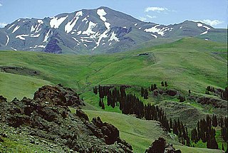
The Wind River Range, is a mountain range of the Rocky Mountains in western Wyoming in the United States. The range runs roughly NW–SE for approximately 100 miles (161 km). The Continental Divide follows the crest of the range and includes Gannett Peak, which at 13,804 feet (4,207 m), is the highest peak in Wyoming. There are more than 40 other named peaks in excess of 13,000 feet (3,962 m). With the exception of the Grand Teton in the Teton Range, the next 19 highest peaks in Wyoming after Gannett are also in the Winds. Two large National Forests including three wilderness areas encompass most of the mountain range. Shoshone National Forest is on the eastern side of the continental divide while Bridger-Teton National Forest is on the west. Both National Forests and the entire mountain range are an integral part of the Greater Yellowstone Ecosystem. Portions of the range are also inside the Wind River Indian Reservation.

Slough Creek (Wyoming) river in the United States of America

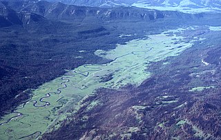
Slough Creek is a tributary of the Lamar River, approximately 25 mi (40 km) long, in Montana and Wyoming in the United States.

Teton River (Idaho) river in the United States of America

The Teton River is an 64-mile-long (103 km) tributary of the Henrys Fork of the Snake River in southeastern Idaho in the United States. It drains through the Teton Valley along the west side of the Teton Range along the Idaho-Wyoming border at the eastern end of the Snake River Plain. Its location along the western flank of the Tetons provides the river with more rainfall than many other rivers of the region.

Jackson Lake lake in Wyoming

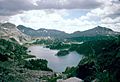
Jackson Lake is in Grand Teton National Park in northwestern Wyoming. This natural lake was enlarged by the construction of the Jackson Lake Dam, which was originally built in 1911, enlarged in 1916 and rebuilt by 1989. The top 33 ft (10 m) of the lake is utilized by farmers in Idaho for irrigation purposes. The lake is the remnant of large glacial gouging from the neighboring Teton Range to the west and the Yellowstone Plateau to the north. The lake is primarily fed by the Snake River, which flows in from the north, and empties at Jackson Lake Dam. Jackson Lake is one of the largest high altitude lakes in the United States, at an elevation of 6,772 ft (2,064 m) above sea level. The lake is up to 15 mi (24 km) long, 7 mi (11 km) wide and 438 ft (134 m) deep. The water of the lake averages below 60 °F (16 °C), even during the summer.

Gannett Peak mountain

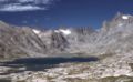
Gannett Peak is the highest mountain peak in the U.S. state of Wyoming at 13,810 feet (4,210 m). It lies in the Wind River Range within the Bridger Wilderness of the Bridger-Teton National Forest. Straddling the Continental Divide along the boundary between Fremont and Sublette counties, it has the second greatest topographic prominence in the state (7076') after Cloud Peak (7077'), and is the highest ground for 290 miles in any direction.

Gros Ventre landslide

The Gros Ventre landslide is located in the Gros Ventre Wilderness of Bridger-Teton National Forest, Wyoming, United States. The Gros Ventre landslide is seven miles (11 km) east of Jackson Hole valley and Grand Teton National Park.

Gallatin National Forest

Founded in 1899, Gallatin National Forest is located in south central Montana, United States. The forest comprises 1,819,515 acres (7,363.32 km2) and has portions of both the Absaroka-Beartooth and Lee Metcalf Wilderness areas within its boundaries. Gallatin National Forest borders Yellowstone National Park on the north and northwest and is part of the Greater Yellowstone Ecosystem, a region which encompasses almost 20,000,000 acres (81,000 km2). The forest is named after Albert Gallatin (1761–1849), U.S. Secretary of the Treasury and scholar of Native American languages and cultures.

John D. Rockefeller Jr. Memorial Parkway protected area

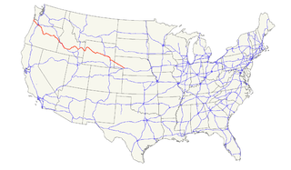
John D. Rockefeller Jr. Memorial Parkway is a scenic road that connects Grand Teton National Park and Yellowstone National Park in the U.S. state of Wyoming. It is federally owned and managed by the National Park Service. It is named in remembrance of John D. Rockefeller Jr., a conservationist and philanthropist who was instrumental in the creation and enlargement of numerous national parks including Grand Teton, Virgin Islands, Acadia and the Great Smoky Mountains.

Shoshone National Forest protected area in Wyoming, USA

Shoshone National Forest is the first federally protected National Forest in the United States and covers nearly 2,500,000 acres (1,000,000 ha) in the state of Wyoming. Originally a part of the Yellowstone Timberland Reserve, the forest is managed by the United States Forest Service and was created by an act of Congress and signed into law by U.S. President Benjamin Harrison in 1891. Shoshone National Forest is one of the first nationally protected land areas anywhere. Native Americans have lived in the region for at least 10,000 years, and when the region was first explored by European adventurers, forestlands were occupied by several different tribes. Never heavily settled or exploited, the forest has retained most of its wildness. Shoshone National Forest is a part of the Greater Yellowstone Ecosystem, a nearly unbroken expanse of federally protected lands encompassing an estimated 20,000,000 acres (8,100,000 ha).

Caribou-Targhee National Forest

Caribou-Targhee National Forest is located in the states of Idaho and Wyoming, with a small section in Utah in the United States. The forest is broken into several separate sections and extends over 2.63 million acres (10,600 km2). To the east the forest borders Yellowstone National Park, Grand Teton National Park and Bridger-Teton National Forest. Most of the forest is a part of the 20-million-acre (81,000 km2) Greater Yellowstone Ecosystem.

Gros Ventre River river in the United States of America

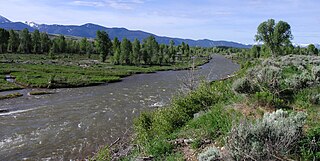
The Gros Ventre River is a 74.6-mile-long (120.1 km) tributary of the Snake River in the state of Wyoming, USA. During its short course, the river flows to the east, north, west, then southwest. It rises in the Gros Ventre Wilderness in western Wyoming, and joins the Snake River in the Jackson Hole valley. In 1925, the massive Gros Ventre landslide dammed the river and formed Lower Slide Lake. The natural dam collapsed in 1927, flooding the downstream town of Kelly, Wyoming. The river is noted for the excellent trout fishing along its length, where native Snake River Fine-spotted Cutthroat Trout average 12 to 16 inches, with some to 20 inches (510 mm).

Lower Slide Lake Lake in Teton County, Wyoming, USA

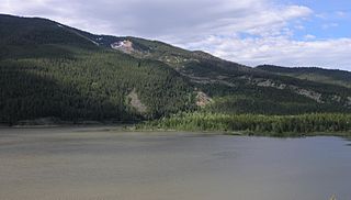
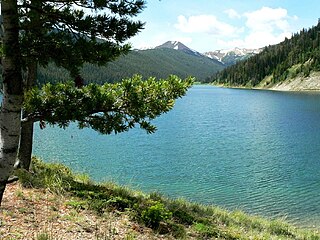
Lower Slide Lake is located in Bridger-Teton National Forest, in the U.S. state of Wyoming. The natural lake was created on June 23, 1925 when the Gros Ventre landslide dammed the Gros Ventre River. The lake was once much larger, however part of the rock dam failed less than two years later, on May 18, 1927, causing deadly flooding downstream. The lake waters have natural and stocked fish including lake and Snake River fine-spotted cutthroat trout, and mountain whitefish.

Wyoming Range mountain range located in west-central Wyoming, United States

The Wyoming Range is a mountain range located in western Wyoming. It is a range of the Rocky Mountains that runs north-south near the western edge of the state. Its highest peak is Wyoming Peak, which stands at 11,383 feet (3,470 m) above sea-level. The range is sometimes referred to as The Wyomings.

Teton National Forest was first established by the General Land Office on February 22, 1897 as the Teton Forest Reserve with 892,440 acres (3,611.6 km2). A commission was established in 1896 to plan for a system of national forest reserves, recommending an expansion of the territory protected by the Yellowstone Timberland Reserve. President Grover Cleveland's 1897 proclamation established a protected area encompassing the northern end of Jackson Hole, extending from the south boundary of the Yellowstone Forest Reserve south to the area of the Gros Ventre River, and from the Idaho border in the west to the area of the Continental Divide in the east. Much of this area would eventually be incorporated into Grand Teton National Park. In 1902 the southern porion of the Yellowstone reserve was added, while the Teton Reserve was greatly expanded to the south and east while excluding the southern portion of Jackson Hole around the town of Jackson.

Bridger National Forest was first established by the U.S. Forest Service on July 1, 1911 in Wyoming with 577,580 acres (2,337.4 km2) from part of Bonneville National Forest. On May 14, 1923 Bridger was transferred Wyoming National Forest, and the name was discontinued. On March 10, 1943 Wyoming was renamed Bridger. In 1973 Bridger National Forest was administratively combined with Teton National Forest, creating Bridger-Teton National Forest. In descending order of land area, Bridger National Forest lands are located in Sublette, Lincoln, Fremont, and Teton counties. There are local ranger district offices in Afton, Big Piney, Kemmerer, and Pinedale. Its administrative headquarters reside in Jackson, Wyoming as part of the combined Bridger-Teton National Forest. Its current area of 1,736,075 acres represents 51.02% of the combined Bridger-Teton's area of 3,402,644 acres. The forest includes all of the National Wilderness Preservation System's officially designated Bridger Wilderness.

Ecology of the Rocky Mountains

The ecology of the Rocky Mountains is diverse due to the effects of a variety of environmental factors. The Rocky Mountains are the major mountain range in western North America, running from the far north of British Columbia in Canada to New Mexico in the southwestern United States, climbing from the Great Plains at or below 1,800 feet (550 m) to peaks of over 14,000 feet (4,300 m). Temperature and rainfall varies greatly also and thus the Rockies are home to a mixture of habitats including the alpine, subalpine and boreal habitats of the Northern Rocky Mountains in British Columbia and Alberta, the coniferous forests of Montana and Idaho, the wetlands and prairie where the Rockies meet the plains, a different mix of conifers on the Yellowstone Plateau in Wyoming and in the high Rockies of Colorado and New Mexico, and finally the alpine tundra of the highest elevations.

Sheep Mountain (Teton County, Wyoming) mountain in Wyoming, United States of America

Sheep Mountain is located in the U.S. state of Wyoming. Sheep Mountain forms a 5-mile (8 km) long ridge in the Gros Ventre Range and is easily seen from Jackson Hole. The town of Jackson, Wyoming is 13 miles (21 km) southwest of the peak. The southern end of Sheep Mountain is above the tree line and consists of rocky cliffs that are referred to as the "Sleeping Indian" due to their appearance as viewed from Jackson Hole. Sheep Mountain is in the Gros Ventre Wilderness of Bridger-Teton National Forest. At the northern end of Sheep Mountain is the location of the Gros Ventre landslide.

References

  1. "Land Areas of the National Forest System" (PDF). U.S. Forest Service. January 2012. Retrieved June 30, 2012.
  2. "Kemmerer Ranger District". Bridger-Teton National Forest. U.S. Forest Service. 2008-08-14.