Chattahoochee-Oconee National Forest

Last updated
Chattahoochee-Oconee National Forest
Cool Springs Overlook, Fort Mountain, Georgia April 2016.jpg
Spring in the Chattahoochee National Forest
Usa edcp relief location map.png
Red pog.svg
Location Georgia, United States
Nearest city Athens, GA
Coordinates 34°45′49″N84°06′56″W / 34.763611°N 84.115556°W / 34.763611; -84.115556 Coordinates: 34°45′49″N84°06′56″W / 34.763611°N 84.115556°W / 34.763611; -84.115556
Area866,468 acres (3,506.47 km2)
EstablishedJuly 9, 1936
Governing body U.S. Forest Service
Website Chattahoochee-Oconee National Forest

The Chattahoochee-Oconee National Forest in northern Georgia comprises two United States National Forests, the Oconee National Forest in eastern Georgia and the Chattahoochee National Forest located in the North Georgia Mountains. The Chattahoochee National Forest is composed of an eastern and western forest. The western forest contains Johns Mountain, Little Sand Mountain, and Taylor Ridge. The combined total area of the Chattahoochee-Oconee National Forest is 866,468 acres (3,506 km2), of which the Chattahoochee National Forest comprises 750,145 acres (3,036 km2) and the Oconee National Forest comprises 116,232 acres (470 km2). [1] The county with the largest portion of the eastern forest is Rabun County, Georgia, which has 148,684 acres (601.7 km2) within its boundaries.

Georgia (U.S. state) State of the United States of America

Georgia is a state in the Southeastern United States. It began as a British colony in 1733, the last and southernmost of the original Thirteen Colonies to be established. Named after King George II of Great Britain, the Province of Georgia covered the area from South Carolina south to Spanish Florida and west to French Louisiana at the Mississippi River. Georgia was the fourth state to ratify the United States Constitution, on January 2, 1788. In 1802–1804, western Georgia was split to the Mississippi Territory, which later split to form Alabama with part of former West Florida in 1819. Georgia declared its secession from the Union on January 19, 1861, and was one of the original seven Confederate states. It was the last state to be restored to the Union, on July 15, 1870. Georgia is the 24th largest and the 8th most populous of the 50 United States. From 2007 to 2008, 14 of Georgia's counties ranked among the nation's 100 fastest-growing, second only to Texas. Georgia is known as the Peach State and the Empire State of the South. Atlanta, the state's capital and most populous city, has been named a global city. Atlanta's metropolitan area contains about 55% of the population of the entire state.

United States National Forest classification of federal lands in the United States

National Forest is a classification of protected and managed federal lands in the United States. National Forests are largely forest and woodland areas owned collectively by the American people through the federal government, and managed by the United States Forest Service, a division of the United States Department of Agriculture.

Johns Mountain Mountain in the US State of Georgia

Johns Mountain is a summit in the U.S. state of Georgia. With an elevation of 1,683 feet (513 m), Johns Mountain is the 666th highest summit in the state of Georgia. The mountain is located inside the Chattahoochee-Oconee National Forest.

Contents

Wildlife

Numerous animals can be found in this forest including birds such as species of hawk, species of owl, blackbirds, ducks, eagles, sparrows, hummingbirds, geese, and cardinals. Mammalian species that roam in the forest are American black bear, shrew, coyote, a variety of bats, squirrel, beaver, river otter, bobcat, deer, weasel, mice, and foxes. The forest is known to be home to the mysterious blue glow of the Blue ghost firefly, Phausis reticulata and many species of fish and amphibians swim in the many streams and lakes; also various species of reptile inhabit the forest.

Hawk group of diurnal birds of prey

Hawks are a group of medium-sized diurnal birds of prey of the family Accipitridae. Hawks are widely distributed and vary greatly in size.

Owl order of birds

Owls are birds from the order Strigiformes, which includes about 200 species of mostly solitary and nocturnal birds of prey typified by an upright stance, a large, broad head, binocular vision, binaural hearing, sharp talons, and feathers adapted for silent flight. Exceptions include the diurnal northern hawk-owl and the gregarious burrowing owl. Baby owls are commonly refereed to as owlets.

The New World blackbirds consist of 26 species of icterid birds that share the name blackbird but do not correspond with a formal taxon. The distributions of all species are limited to the Americas, and this group is distinct from the Eurasian common blackbird.

History

The Chattahoochee National Forest takes its name from the Chattahoochee River whose headwaters begin in the North Georgia mountains. [2] The River and the area were given the name by the English settlers who took the name from the Indians living here. The Cherokee and Creek Indians inhabited North Georgia. In one dialect of the Muskogean languages, Chatta means stone; ho chee, marked or flowered. These marked or flowered stones were in the Chattahoochee River at a settlement near Columbus, Georgia.

Chattahoochee River river in the USA

The Chattahoochee River forms the southern half of the Alabama and Georgia border, as well as a portion of the Florida - Georgia border. It is a tributary of the Apalachicola River, a relatively short river formed by the confluence of the Chattahoochee and Flint rivers and emptying from Florida into Apalachicola Bay in the Gulf of Mexico. The Chattahoochee River is about 430 miles (690 km) long. The Chattahoochee, Flint, and Apalachicola rivers together make up the Apalachicola–Chattahoochee–Flint River Basin. The Chattahoochee makes up the largest part of the ACF's drainage basin.

North Georgia mountains

The Georgia Mountains Region or North Georgia mountains or Northeast Georgia is an area that starts in the northeast corner of Georgia, United States, and spreads in a westerly direction. The mountains in this region are in the Blue Ridge mountain chain that ends in Georgia. At over 1 billion years of age, the Blue Ridge mountains are among the oldest mountains in the United States and sometimes mistaken to be the oldest mountains in the world. The mountains in this region are also a part of the vast system of North American mountains known as the Appalachian Mountains that spans most of the United States longitudally along the eastern areas of the nation and terminates in Alabama.

The Cherokee are one of the indigenous people of the Southeastern Woodlands. Prior to the 18th century, they were concentrated in southwestern North Carolina, southeastern Tennessee, and the tips of western South Carolina and northeastern Georgia.

Anna Ruby Falls Anna Ruby Falls 2.JPG
Anna Ruby Falls

In 1911, the United States Forest Service purchased 31,000 acres (125 km2) of land in Fannin, Gilmer, Lumpkin and Union Counties from the Gennett family for $7 per acre. This land was the beginning of what would become the Chattahoochee National Forest. The initial land purchases became a part of the Cherokee National Forest on June 14, 1920.

United States Forest Service federal forest and grassland administrators

The United States Forest Service (USFS) is an agency of the U.S. Department of Agriculture that administers the nation's 154 national forests and 20 national grasslands, which encompass 193 million acres (780,000 km2). Major divisions of the agency include the National Forest System, State and Private Forestry, Business Operations, and the Research and Development branch. Managing approximately 25% of federal lands, it is the only major national land agency that is outside the U.S. Department of the Interior.

Fannin County, Georgia County in the United States

Fannin County is a county located in the north central portion of the U.S. state of Georgia. As of the 2010 census, the population was 23,682. The county seat is Blue Ridge. The county was created on January 21, 1854.

Gilmer County, Georgia County in the United States

Gilmer County is a county located in the north central portion of the U.S. state of Georgia. As of the 2010 census, the population was 28,292. The county seat is Ellijay. The county was created on December 3, 1832 and was named for George Rockingham Gilmer.

Ranger Roscoe Nicholson, who was the first forest ranger in Georgia and had advised the Forest Service in its initial land purchases, continued the growth of the Chattahoochee by negotiating the purchase of most of the Forest Service land in what is now the Chattooga River Ranger District. The Coleman River Scenic Area near Clayton, Georgia was dedicated to "Ranger Nick", as he was called, in honor of his promotion of conservation ideals.

Roscoe Conklin Nicholson was a surveyor and early advocate of conservation, who played an important role in preserving forest land in the U.S. state of Georgia in the early 20th century.

The Coleman River Scenic Area is located in Rabun County, Georgia in the Chattooga River District of the Chattahoochee National Forest. It is located at the point of confluence of Coleman River with the Tallulah River. The scenic area consists of 330 acres (1.3 km2) encompassing lower Coleman River and was dedicated in 1960 to "Ranger Nick" Nicholson following his 40 years of public service. At the point of confluence of the two rivers, the elevation is approximately 2,200 feet (670 m).

Clayton, Georgia City in Georgia, United States

Clayton is a city in Rabun County, Georgia, United States. The population was 2,047 at the 2010 census. The city is the county seat of Rabun County and is located in the Blue Ridge Mountains.

Ranger Arthur Woody also promoted conservation and was a key figure in the early development of the Chattahoochee. Unwise land and resource use had caused the deer and trout populations to virtually disappear in the North Georgia mountains and Woody brought trout and deer back to the area. The trout were shipped to Gainesville, hauled across the narrow, dirt, mountain roads and eventually released in the streams. Woody also purchased fawns with his own money, and fed them until they could be released on what became the Blue Ridge Wildlife Management Area. Many landmarks in the Chattahoochee bear Ranger Woody’s name in tribute to his work. Sosebee Cove, a 175 acres (0.7 km2) tract of prize hardwood along GA 180 is set aside as a memorial to Woody, who negotiated its purchase for the Forest Service.

Arthur Woody was born in Suches, Georgia. He was an American conservationist and humanitarian who saw his father kill the last deer in the North Georgia mountains in 1895, and is credited with bringing deer back to the North Georgia mountains. As a forest ranger for the United States Forest Service, he served in Georgia from 1912 to 1945 and was involved in the acquisition of land in what became the Chattahoochee National Forest. He also is known for putting rainbow and brown trout in streams, restoring native brook trout, restoring turkey and black bear populations and was the driving force behind Blue Ridge Wildlife Management Area, the first of its kind in Georgia and the nation. He built lakes, fire towers, brought roads to the area, built Woody Gap School in Suches, Georgia (1940), was instrumental in building the Appalachian Trail through Georgia, and did much to help his mountain people during the Great Depression.

Trout Number of species of freshwater fish

Trout is the common name for a number of species of freshwater fish belonging to the genera Oncorhynchus, Salmo and Salvelinus, all of the subfamily Salmoninae of the family Salmonidae. The word trout is also used as part of the name of some non-salmonid fish such as Cynoscion nebulosus, the spotted seatrout or speckled trout.

The Blue Ridge Wildlife Management Area consists of 39,000 acres (160 km2) located in the Chattahoochee National Forest in Dawson, Fannin and Lumpkin counties in Georgia.

On July 9, 1936, the Forest Service was reorganized to follow state boundaries and President Franklin D. Roosevelt proclaimed the Chattahoochee a separate National Forest. In 1936, the Chattahoochee was organized into two Ranger Districts, the Blue Ridge and the Tallulah.

In 1959, President Dwight D. Eisenhower proclaimed 96,000 acres (388 km2) of federal lands in central Georgia as the Oconee National Forest. The Oconee then joined the Chattahoochee to become the Chattahoochee-Oconee National Forests of today.

The Chattooga River was designated a Wild and Scenic River during the 1970s. The Chattooga remains one of the few free-flowing streams in the Southeast and is known for its white water rafting and scenery.[ citation needed ] The movie Deliverance was filmed on the Chattooga River, which became the fictional Cahulawassee River in the movie.

Today

General map of the Chattahoochee-Oconee National Forest. 20090923-portal-locator-map.jpg
General map of the Chattahoochee-Oconee National Forest.

The Chattahoochee National Forest today covers 18 north Georgia counties. The Chattahoochee currently has three ranger districts:

It includes over 2,200 miles (3,500 km) of rivers and streams (including about 1,367 miles (2,200 km) of trout streams). There are over 450 miles (720 km) of hiking and other recreation trails, and 1,600 miles (2,600 km) of "roads." In addition to the Chattooga River and the headwaters of the Chattahoochee River, natural attractions within it boundaries include the beginning of the 2,174-mile (3,499 km) Appalachian Trail, Georgia's highpoint, Brasstown Bald and Anna Ruby Falls.

The Chattahoochee also includes ten wildernesses that are part of the National Wilderness Preservation System, all of which are managed by the United States Forest Service. Parts of these wilderness extend outside Chattahoochee National Forest, as indicated. The wildernesses are:

  1. Big Frog Wilderness (Cherokee NF in Tennessee and Chattahoochee NF in Georgia)
  2. Blood Mountain Wilderness
  3. Brasstown Wilderness
  4. Cohutta Wilderness (Chattahoochee NF in Georgia and Cherokee NF in Tennessee)
  5. Ellicott Rock Wilderness (Nantahala NF in North Carolina; Sumter NF in South Carolina; and Chattahoochee NF in Georgia)
  6. Mark Trail Wilderness
  7. Raven Cliffs Wilderness
  8. Rich Mountain Wilderness
  9. Southern Nantahala Wilderness (Chattahoochee NF in Georgia and Nantahala NF in North Carolina)
  10. Tray Mountain Wilderness

The Oconee National Forest today is spread over eight Georgia counties and is organized into one ranger district. The Oconee Ranger District maintains several hiking and other recreational trails in the forest. Forest headquarters are located in Gainesville, Georgia.

Georgia counties

Map showing the lands of the National Forest GA National Forest.png
Map showing the lands of the National Forest

Listed below are the counties with land in the Forest showing the area and the relevant ranger districts. [3]

Chattahoochee National Forest

Chattooga River Ranger District

Conasauga Ranger District

Cohutta Mountains Cohutta Overlook, Murray County, Georgia.JPG
Cohutta Mountains

Blue Ridge Ranger District

Big Bald Mountain Big Bald Mountain, Georgia 2.JPG
Big Bald Mountain

Oconee National Forest

The Oconee National Forest is almost halfway between Macon and Athens. There are two major man-made lakes within the boundaries of the Oconee Ranger District, both on the Oconee River. Lake Sinclair lends its water and name to Lake Sinclair Recreation Area in Putnam County. This is the major recreation area of the Oconee Ranger District and offers camping, boating, fishing and swimming. Redlands Recreation area is located on Lake Oconee in Greene County and offers boating, picnicking and fishing. Oconee River Recreation Area, farther upstream and near the northern boundary of the National Forest offers camping and boating. There are many miles of hiking and equestrian trails within the forest and one trail for dirt bikes and four-wheelers. Hunt camps dispersed throughout the district are temporarily home to hundreds of hunters who enjoy the forest during deer hunting season. An active timber program insures the health of the forest.

Oconee Ranger District

See also

Related Research Articles

Cherokee National Forest

The Cherokee National Forest is a large National Forest created on June 14, 1920 and managed by the U.S. Forest Service and encompassing some 655,598 acres (2,653.11 km2).

Chattooga River river in the United States of America

The Chattooga River is the main tributary of the Tugaloo River. Its headwaters are located southwest of Cashiers, North Carolina, and it stretches 57 miles (92 km) to where it has its confluence with the Tallulah River within Lake Tugalo, held back by the Tugalo Dam. The Chattooga and the Tallulah combine to make the Tugaloo River starting at the outlet of Lake Tugalo. The Chattooga begins in southern Jackson County, North Carolina, then flows southwestward between northwestern Oconee County, South Carolina, and eastern Rabun County, Georgia. The "Chattooga" spelling was approved by the US Board on Geographic Names in 1897.

White River National Forest

White River National Forest is a National Forest in northwest Colorado. It is named after the White River that passes through its northern section. It is the most visited National Forest in the United States, primarily from users of the twelve ski areas within its boundaries.

Shasta–Trinity National Forest

The Shasta–Trinity National Forest is a federally designated forest in northern California, USA. It is the largest National Forest in California and is managed by the U.S. Forest Service. The 2,210,485 acre forest encompasses five wilderness areas, hundreds of mountain lakes and 6,278 miles (10,103 km) of streams and rivers. Major features include Shasta Lake, the largest man-made lake in California and Mount Shasta, elevation 14,179 feet (4,322 m).

Pisgah National Forest

Pisgah National Forest is a National Forest in the Appalachian Mountains of western North Carolina. It is administered by the United States Forest Service, part of the United States Department of Agriculture. The Pisgah National Forest is completely contained within the state of North Carolina. The forest is managed together with the other three North Carolina National Forests from common headquarters in Asheville, North Carolina. There are local ranger district offices located in Pisgah Forest, Mars Hill, and Nebo.

Conasauga River river in the United States of America

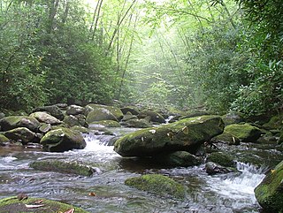
The Conasauga River is a river that runs through southeast Tennessee and northwest Georgia. The Conasauga River is 93 miles (150 km) long and is home to 90 species of fish and 25 species of freshwater mussels. The Conasauga River watershed encompasses over 500,000 acres (2,000 km2) in two states, multiple counties, and two ecologically different regions.

Bartram Trail

The Bartram Trail follows the approximate route of 18th-century naturalist William Bartram’s southern journey from March 1773 to January 1777. Bartram explored much of the territory which is now the states of North and South Carolina, Georgia, Florida, Alabama, Mississippi, Louisiana and Tennessee.

Nantahala National Forest

The Nantahala National Forest, established in 1920, is a national forest located in the American state of North Carolina. The word "Nantahala" is a Cherokee word meaning "Land of the Noonday Sun." The name is appropriate as, in some spots, the sun only reaches the floors of the deep gorges of the forest when high overhead at midday. The Spanish Conquistador Hernando de Soto explored the area in 1540, as did William Bartram in the 18th century. The Nantahala River flows through the Nantahala National Forest.

Tallulah Ranger District

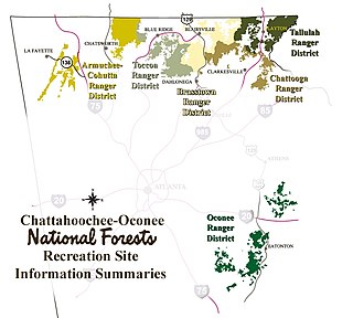
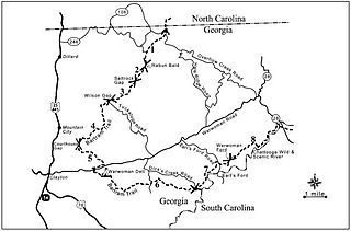
The Tallulah Ranger District is one of the five ranger districts of the Chattahoochee National Forest. The largest portion of the district is located in Rabun County, Georgia, which contains nearly 149,000 acres (600 km2). A portion of the Tallulah Ranger District is also found in Towns County. Both the Appalachian Trail and the Bartram Trail are located in the district.

Southern Nantahala Wilderness

The Southern Nantahala Wilderness was designated in 1984 and currently consists of 23,473 acres (94.99 km2). Approximately 11,770 acres (47.6 km2) are located in Georgia in the Chattahoochee National Forest and approximately 11,703 acres (47.36 km2) are located in North Carolina in the Nantahala National Forest. The Wilderness is managed by the United States Forest Service and is part of the National Wilderness Preservation System. The highest elevation in the Southern Nantahala Wilderness is the 5,499-foot peak of Standing Indian Mountain in North Carolina and the lowest elevation is approximately 2,400 feet (730 m). The Appalachian Trail passes through the Wilderness in both states.

Tray Mountain Wilderness

The Tray Mountain Wilderness was designated in 1986 and currently consists of 9,702 acres (39.26 km2). The Wilderness is located within the borders of the Chattahoochee National Forest in Habersham, Rabun, Towns and White counties, Georgia and is managed in the Chattooga Ranger District. The Wilderness is managed by the United States Forest Service and is part of the National Wilderness Preservation System.

Rich Mountain (Georgia) Mountain in the US State of Georgia

Rich Mountain, elevation 4,040 feet (1,230 m), is the highest point in the Rich Mountain Wilderness of the Chattahoochee National Forest in Gilmer County, Georgia. It is the second-highest peak in Gilmer County; only Big Bald Mountain is taller, with its summit at 4,081 feet (1,244 m).

Ellicott Rock Wilderness

Ellicott Rock Wilderness is managed by the United States Forest Service and is part of the National Wilderness Preservation System. It was first designated by Congress in 1975 with the Eastern Wilderness Act. The majority of this land lays in South Carolina. Additional lands were added to Ellicott Rock Wilderness in 1984 with the passing of the North Carolina Wilderness Act and the Georgia Wilderness Act, today designated wilderness totals 8,274 acres (33.48 km2). Ellicott Rock Wilderness is the only wilderness that straddles three states, with boundaries located around the point at which Georgia, North Carolina, and South Carolina come together. Ellicott Rock Wilderness also spans three National Forests. Sumter National Forest in South Carolina is responsible for 2,859 acres (11.57 km2), receives the majority of recreation in the wilderness, and also acts as the lead manager of Ellicott Rock Wilderness. Nantahala National Forest in North Carolina is responsible for the majority of the wilderness at 3,394 acres (13.74 km2) and the Chattahoochee National Forest in Georgia manages 2,021 acres (8.18 km2) of wilderness. In 1979, Forest Service land was surveyed under the Roadless Area Review and Evaluation and 1,982 acres (8.02 km2) adjacent to the existing wilderness were classified as Roadless National Forest System land, named Ellicott Rock Extension. The Andrew Pickens Ranger district on the Sumter National Forest recommended the Ellicott Rock Extension as wilderness in 1995 in their Resource Management Plan. In June of 2017 during a land management plan revision, the Nantahala Ranger District on the Nantahala National Forest added 824 acres (3.33 km2) of proposed wilderness, currently called Ellicott Rock West Extension.

Sumter National Forest

The Sumter National Forest is one of two forests in South Carolina that are managed together by the United States Forest Service, the other being the Francis Marion National Forest. The Sumter National Forest consists of 370,442 acres (1,499.13 km2) which are divided into several non-contiguous sections in western South Carolina. Overall, in descending order of land area the forest is located in parts of Oconee, Union, Newberry, McCormick, Edgefield, Abbeville, Laurens, Chester, Fairfield, Greenwood, and Saluda counties. Forest headquarters of both South Carolina forests are located together in the state's capital city of Columbia.

Horsetrough Falls waterfall

Horsetrough Falls are located on one of the flanks of Horsetrough Mountain in Union County, Georgia. This 70-foot (21 m) waterfall is located on a creek that is part of the headwaters of the Chattahoochee River and is in the Mark Trail Wilderness. There is an observation platform at the falls which can be reached by the 0.4-mile (0.64 km) Horsetrough Falls Trail. The trail begins at the nearby Upper Chattahoochee Campground camping area, which is maintained and operated by the Chattooga Ranger District of the Chattahoochee National Forest. The Eastern Continental Divide follows the main ridge line of Horsetrough Mountain and the water passes over Horsetrough Falls to begin a 500-mile (800 km) journey to the Gulf of Mexico via the Chattahoochee River.

Armuchee-Cohutta Ranger District

The Armuchee-Cohutta Ranger District is one of the five ranger districts of the Chattahoochee National Forest. Armuchee is thought to be derived from the Cherokee word for "hominy," to be derived from the Choctaw word alurnushi, meaning "hiding place" or mean the "land of the flowers." Cohutta is derived from the Cherokee word cohutta, which means "frog" or could mean "a shed roof supported on poles." The district is spread through portions of Catoosa, Chattooga, Fannin, Floyd, Gilmer, Gordon, Murray, Walker and Whitfield Counties in Georgia. Some of the features within the borders of the district are the Big Frog Wilderness, the Cohutta Wilderness and the Rich Mountain Wilderness.

Protected areas of Georgia (U.S. state)

The protected areas of Georgia cover almost one million acres (4,000 km²) of the state. These areas are managed by different federal and state level authorities and receive varying levels of protection. Some areas are managed as wilderness while others are operated with acceptable commercial exploitation. On the Federal level, Georgia contains 1 Biosphere Reserve, 15 National Park Service Managed Sites, 1 National Forest and 8 Wildlife Refuges. Georgia is home to 63 state parks, 48 of which are state parks and 15 that are National Historic Sites, and many state wildlife preserves, under the supervision of the Georgia Department of Parks and Recreation, a division of the Georgia Department of Natural Resources.

References

  1. "Land Areas of the National Forest System" (PDF). U.S. Forest Service. January 2012. Retrieved 19 June 2012.
  2. "Floyd County". Calhoun Times. September 1, 2004. p. 57. Retrieved 24 April 2015.
  3. 2011 Forest Quick Facts