Chequamegon-Nicolet National Forest

Last updated
Chequamegon-Nicolet National Forest
IUCN category VI (protected area with sustainable use of natural resources)
NicoletNF.jpg
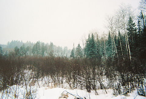
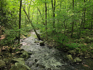
The Nicolet National Forest in November
Usa edcp relief location map.png
Red pog.svg
Location Wisconsin, United States
Coordinates 46°08′03″N90°51′25″W / 46.13417°N 90.85693°W / 46.13417; -90.85693 Coordinates: 46°08′03″N90°51′25″W / 46.13417°N 90.85693°W / 46.13417; -90.85693
Area 1,534,225 acres (6,208.79 km2) [1]
Established 1933 [2]
Governing body U.S. Forest Service
Website Chequamegon-Nicolet National Forest

The Chequamegon-Nicolet National Forest ( /ʃɪˈwɑːmɪɡənˌnɪkəˈl/ ; the q is silent) [3] is a 1,530,647-acre (6,194.31 km2) U.S. National Forest in northern Wisconsin in the United States. Much of the old growth forest in this region was destroyed by logging in the early part of the 20th century. Some of the trees that grow there today were planted by the Civilian Conservation Corps in the 1930s.

Wisconsin A north-central state of the United States of America

Wisconsin is a U.S. state located in the north-central United States, in the Midwest and Great Lakes regions. It is bordered by Minnesota to the west, Iowa to the southwest, Illinois to the south, Lake Michigan to the east, Michigan to the northeast, and Lake Superior to the north. Wisconsin is the 23rd largest state by total area and the 20th most populous. The state capital is Madison, and its largest city is Milwaukee, which is located on the western shore of Lake Michigan. The state is divided into 72 counties.

Logging the cutting, skidding, on-site processing, and loading of trees or logs onto transport vehicles

Logging is the cutting, skidding, on-site processing, and loading of trees or logs onto trucks or skeleton cars.

Civilian Conservation Corps public work relief program

The Civilian Conservation Corps (CCC) was a public work relief program that operated from 1933 to 1942 in the United States for unemployed, unmarried men. Originally for young men ages 18–25, it was eventually expanded to ages 17–28. Robert Fechner was the first director of the agency, succeeded by James McEntee following Fechner's death. The CCC was a major part of President Franklin D. Roosevelt's New Deal that provided unskilled manual labor jobs related to the conservation and development of natural resources in rural lands owned by federal, state, and local governments. The CCC was designed to provide jobs for young men and to relieve families who had difficulty finding jobs during the Great Depression in the United States. Maximum enrollment at any one time was 300,000. Through the course of its nine years in operation, 3 million young men participated in the CCC, which provided them with shelter, clothing, and food, together with a wage of $30 per month.

Contents

Legally two separate national foreststhe Chequamegon National Forest and the Nicolet National Forestthe areas were established by presidential proclamations in 1933 and have been managed as one unit since 1993.

The Chequamegon National Forest comprises three units in the north-central part of the state totaling 865,825 acres (3,503.87 km2). In descending order of forestland area, it is located in parts of Bayfield, Ashland, Price, Sawyer, Taylor, and Vilas counties. Forest headquarters are in Park Falls. There are local ranger district offices in Glidden, Hayward, Medford, Park Falls, and Washburn. [4] Moquah Barrens Research Natural Area is located with the Chequamegon. [5] Lying within the Chequamegon are two officially designated wilderness areas of the National Wilderness Preservation System. These are the Porcupine Lake Wilderness and the Rainbow Lake Wilderness.

Bayfield County, Wisconsin County in the United States

Bayfield County is a county located in the U.S. state of Wisconsin. As of the 2010 census, the population was 15,014. Its county seat is Washburn. The county was created in 1845 and organized in 1850.

Ashland County, Wisconsin County in the United States

Ashland County is a county located in the U.S. state of Wisconsin. As of the 2010 census, the population was 16,157. Its county seat is Ashland. The county was formed on March 27, 1860, from La Pointe County.

Price County, Wisconsin County in the United States

Price County is a county in the U.S. state of Wisconsin. As of the 2010 census, the population was 14,159. Its county seat is Phillips.

The Nicolet National Forest covers 664,822 acres (2,690.44 km2) of northeastern Wisconsin. It is located in parts of Forest, Oconto, Florence, Vilas, Langlade, and Oneida counties. Forest headquarters are in Rhinelander. There are local ranger district offices in Eagle River, Florence, Lakewood, and Laona. Bose Lake Hemlock Hardwoods and the Franklin Lake Campground are located in the Nicolet. [6] [7] Lying within the Nicolet are three wildernesses—the Blackjack Springs Wilderness, the Headwaters Wilderness, and the Whisker Lake Wilderness.

Forest County, Wisconsin County in the United States

Forest County is a county in the U.S. state of Wisconsin. As of the 2010 census, the population was 9,304. Its county seat is Crandon.

Oconto County, Wisconsin County in the United States

Oconto County is a county in the U.S. state of Wisconsin. As of the 2010 census, the population was 37,660. Its county seat is Oconto. The county was established in 1851.

Florence County, Wisconsin County in the United States

Florence County is a county located in the U.S. state of Wisconsin. As of the 2010 census, the population was 4,423, making it the second-least populous county in Wisconsin. Its county seat is Florence.

Flora and fauna

A wintry scene in Chequamegon-Nicolet National Forest. Chequamegon.jpg
A wintry scene in Chequamegon-Nicolet National Forest.
A barred owl along a highway in the Nicolet National Forest. BarredOwl.jpg
A barred owl along a highway in the Nicolet National Forest.

Remote areas of uplands, bogs, wetlands, muskegs, rivers, streams, pine savannas, meadows and many glacial lakes are found throughout these forests. Native tree species include Acer saccharum (sugar maple), Acer rubrum (red maple), and Acer spicatum (mountain maple), white, red, and black oaks, aspen, beech, basswood, sumac, and paper, yellow, and river birch. Coniferous trees, including red, white, and jack pine, white spruce and balsam fir are abundant due to a dense second growth. Eastern hemlock are also present as this is the westernmost limit of its distribution. Tamarack/black spruce bogs, cedar swamps and alder thickets are common. Blueberries, raspberries, blackberries, cranberries, serviceberries, ferns, mosses, cattails, and mushrooms also grow here, as well as many more shrubs and wildflowers.

Bog wetland that accumulates peat due to incomplete decomposition of plant leftovers

A bog or bogland is a wetland that accumulates peat, a deposit of dead plant material—often mosses, and in a majority of cases, sphagnum moss. It is one of the four main types of wetlands. Other names for bogs include mire, quagmire, and muskeg; alkaline mires are called fens. They are frequently covered in ericaceous shrubs rooted in the sphagnum moss and peat. The gradual accumulation of decayed plant material in a bog functions as a carbon sink.

Muskeg soil type

Muskeg is an acidic soil type common in Arctic and boreal areas, although it is found in other northern climates as well. Muskeg is approximately synonymous with bogland, but "muskeg" is the standard term in Western Canada and Alaska, while 'bog' is common elsewhere. The term became common in these areas because it is of Cree origin; maskek (ᒪᐢᑫᐠ) meaning low-lying marsh. Large tracts of this soil existing in Siberia may be called muskeg or bogland interchangeably.

<i>Acer saccharum</i> species of plant

Acer saccharum, the sugar maple or rock maple, is a species of maple native to the hardwood forests of eastern Canada, from Nova Scotia west through southern Quebec, central and southern Ontario to southeastern Manitoba around Lake of the Woods, and the northern parts of the Central and Eastern United States, from Minnesota eastward to the highlands of the upper eastern states and the interior Midwest. Sugar maple is best known for its bright fall foliage and for being the primary source of maple syrup.

White-tailed deer are numerous and are hit by motorists on roads in northern Wisconsin year-round. Black bears, foxes, raccoons, rabbits, beavers, river otters, squirrels, chipmunks, pheasants, grouse and wild turkeys are popular game in the woods. Elk and wolves have been reintroduced and there have been sightings of moose and pine marten. [8] Bird species include northern cardinal, blue jay, gray jay, common raven, boreal and black-capped chickadees, black-backed and pileated woodpeckers, red-winged blackbirds, owls, ducks, common loons, bald eagles, evening grosbeaks, red and white-winged crossbills and many species of thrushes, sparrows and warblers. Brook trout, rainbow trout, and brown trout are found in many miles of excellent streams. Walleye, small and largemouth bass, crappie, northern pike, and many species of panfish make the area's lakes famous for freshwater fishing. A record making muskellunge, Wisconsin's state fish, was caught in these waters. The beauty, heritage, and recreational opportunities of these forests draw thousands of tourists to the Chequamegon-Nicolet area every year.

White-tailed deer species of mammal

The white-tailed deer, also known as the whitetail or Virginia deer, is a medium-sized deer native to the United States, Canada, Mexico, Central America, and South America as far south as Peru and Bolivia. It has also been introduced to New Zealand, Cuba, Jamaica, Hispaniola, Puerto Rico, the Bahamas, the Lesser Antilles, and some countries in Europe, such as Finland, the Czech Republic, Romania and Serbia. In the Americas, it is the most widely distributed wild ungulate.

Cinnamon bear subspecies of bear

The cinnamon bear is both a highly variable color morph and a subspecies of the American black bear, native to the central and western areas of the United States and Canada. Established populations are found in Colorado, New Mexico, Utah, Idaho, Montana, Washington, Manitoba, Minnesota, Wisconsin, Wyoming, California, Alberta, and British Columbia. They also have been seen in Pennsylvania and New York. The most striking difference between a cinnamon bear and any other black bear is its brown or red-brown fur, reminiscent of cinnamon. The subspecies was given this designation because the lighter color phase is more common there than in other areas.

Fox omnivorous mammal in the Canidae family

Foxes are small-to-medium-sized, omnivorous mammals belonging to several genera of the family Canidae. Foxes have a flattened skull, upright triangular ears, a pointed, slightly upturned snout, and a long bushy tail.

These national forests are best known for recreation, including camping, hiking, fishing, cross country skiing, and snowmobiling.

Recreation activity of leisure

Recreation is an activity of leisure, leisure being discretionary time. The "need to do something for recreation" is an essential element of human biology and psychology. Recreational activities are often done for enjoyment, amusement, or pleasure and are considered to be "fun".

Camping outdoor recreational activity

Camping is an outdoor activity involving overnight stays away from home in a shelter, such as a tent. Typically participants leave developed areas to spend time outdoors in more natural ones in pursuit of activities providing them enjoyment. To be regarded as "camping" a minimum of one night is spent outdoors, distinguishing it from day-tripping, picnicking, and other similarly short-term recreational activities. Camping can be enjoyed through all four seasons.

Hiking walking as a hobby, sport, or leisure activity

Hiking is the preferred term, in Canada and the United States, for a long, vigorous walk, usually on trails (footpaths), in the countryside, while the word walking is used for shorter, particularly urban walks. On the other hand, in the United Kingdom, and the Republic of Ireland, the word "walking" is acceptable to describe all forms of walking, whether it is a walk in the park or backpacking in the Alps. The word hiking is also often used in the UK, along with rambling, hillwalking, and fell walking. The term bushwalking is endemic to Australia, having been adopted by the Sydney Bush Walkers club in 1927. In New Zealand a long, vigorous walk or hike is called tramping. It is a popular activity with numerous hiking organizations worldwide, and studies suggest that all forms of walking have health benefits.

The Chequamegon National Forest was also home to one of the two extremely low frequency antennae in the United States.

See also

Related Research Articles

Northeastern coastal forests

The Northeastern coastal forests are a temperate broadleaf and mixed forests ecoregion of the northeast and middle Atlantic region of the United States. The ecoregion covers an area of 34,630 sq miles (89,691 km²) encompassing the Piedmont and coastal plain of seven states, extending from coastal southwestern Maine, southeastern New Hampshire, eastern Massachusetts, and Rhode Island, southward through Connecticut, New York State, New Jersey, southeast Pennsylvania, Delaware and Maryland.

Allegheny National Forest

The Allegheny National Forest is a National Forest in northwestern Pennsylvania. The forest covers 513,175 acres of land. Within the forest is Kinzua Dam, which impounds the Allegheny River to form Allegheny Reservoir. The administrative headquarters for the Allegheny National Forest is in Warren. The Allegheny National Forest has two ranger stations, one in Marienville, Forest County, and the other in Bradford, McKean County.

Desolation Wilderness protected area

The Desolation Wilderness is a 63,960-acre (258.8 km2) federally protected wilderness area in the Eldorado National Forest and Lake Tahoe Basin Management Unit, in El Dorado County, California. The crest of the Sierra Nevada runs through it, just west of Lake Tahoe.

Porcupine Mountains mountain in United States of America

The Porcupine Mountains, or Porkies, are a group of small mountains spanning the northwestern Upper Peninsula of Michigan in Ontonagon and Gogebic counties, near the shore of Lake Superior. The Porcupine Mountains were named by the native Ojibwa people, supposedly because their silhouette had the shape of a crouching porcupine. They are home to the most extensive stand of old growth northern hardwood forest in North America west of the Adirondack Mountains, spanning at least 31,000 acres (13,000 ha). In these virgin forests, sugar maple, American basswood, eastern hemlock, and yellow birch are the most abundant tree species. The area is part of the Porcupine Mountains Wilderness State Park.

Superior National Forest

Superior National Forest, part of the United States National Forest system, is located in the Arrowhead Region of the state of Minnesota between the Canada–United States border and the north shore of Lake Superior. The area is part of the greater Boundary Waters region along the border of Minnesota and the Canadian province of Ontario, a historic and important thoroughfare in the fur trading and exploring days of New France and British North America.

Shasta–Trinity National Forest

The Shasta–Trinity National Forest is a federally designated forest in northern California, USA. It is the largest National Forest in California and is managed by the U.S. Forest Service. The 2,210,485 acre forest encompasses five wilderness areas, hundreds of mountain lakes and 6,278 miles (10,103 km) of streams and rivers. Major features include Shasta Lake, the largest man-made lake in California and Mount Shasta, elevation 14,179 feet (4,322 m).

Slide Mountain Wilderness Area

The Slide Mountain Wilderness Area is, at 47,500 acres (19,200 ha), the largest tract of state-owned Forest Preserve in New York's Catskill Park, and the largest area under any kind of wilderness area protection between the Adirondacks and the southern Appalachians. It is located in the towns of Shandaken, Denning and Olive in Ulster County.

Appalachian mixed mesophytic forests ecoregion in the eastern United States

The Appalachian mixed mesophytic forests is an ecoregion of the temperate broadleaf and mixed forests biome, as defined by the World Wildlife Fund. It consists of mesophytic plants west of the Appalachian Mountains in the Southeastern United States.

Sabine National Forest

Sabine National Forest is located in East Texas near the Texas-Louisiana border. The forest is administered together with the other three United States National Forests and two National Grasslands located entirely in Texas, from common offices in Lufkin, Texas. There are local ranger district offices located in Hemphill.

Appalachian-Blue Ridge forests

The Appalachian-Blue Ridge forests is an ecoregion in the Temperate broadleaf and mixed forests Biome, in the Eastern United States. The ecoregion is located in the central and southern Appalachian Mountains, including the Ridge-and-Valley Appalachians and the Blue Ridge Mountains. It covers an area of about 61,500 square miles (159,000 km2) in: northeast Alabama and Georgia, northwest South Carolina, eastern Tennessee, western North Carolina, Virginia, Maryland, and central West Virginia and Pennsylvania; and small extensions into Kentucky, New Jersey, and New York.

New England/Acadian forests

The New England-Acadian forests are a temperate broadleaf and mixed forest ecoregion that includes a variety of habitats on the hills, mountains and plateaus of New England in the Northeastern United States and Quebec and the Maritime Provinces of Eastern Canada.

Siuslaw National Forest

The Siuslaw National Forest is a national forest in western Oregon in the United States. Established in 1908, the Siuslaw is made up of a wide variety of ecosystems, ranging from coastal forests to sand dunes.

Allegheny Highlands forests

The Allegheny Highlands forests are a temperate broadleaf and mixed forests ecoregion of North America, as defined by the World Wildlife Fund.

Eastern forest-boreal transition

The Eastern forest-boreal transition is a temperate broadleaf and mixed forests ecoregion of North America, mostly in eastern Canada.

Blackjack Springs Wilderness

The Blackjack Springs Wilderness is a 5,800-acre (23 km2) wilderness area northeast of Eagle River, Wisconsin. It is located within the Nicolet unit of the Chequamegon-Nicolet National Forest and is administered by the US Forest Service. The area protects four large, crystal-clear springs at the headwaters of Blackjack Creek, part of the Eagle River and Wisconsin River drainage. The area was added to the National Wilderness Preservation System by Congress in 1978.

Bose Lake Hemlock Hardwoods

Bose Lake Hemlock Hardwoods is a mature northern hardwood-hemlock stand located within Chequamegon-Nicolet National Forest in Oneida County, Wisconsin. It was designated a National Natural Landmark in 1980. Additionally, it is located within the Franklin and Butternut Lakes Wisconsin State Natural Area.

Moquah Barrens Research Natural Area

Moquah Barrens Research Natural Area is a 636-acre (257 ha) area of pine barrens in Bayfield County, Wisconsin. It is located within the Chequamegon-Nicolet National Forest. The area was designated a Wisconsin State Natural Area in 1970 and a National Natural Landmark in 1980.

Headwaters Wilderness

The Headwaters Wilderness is a 22,033-acre (89 km2) wilderness area located within the Nicolet unit of the Chequamegon-Nicolet National Forest in northeastern Wisconsin. It is the largest federally designated wilderness area on Wisconsin's mainland.

The White Lake Wilderness Area is a wilderness area located in Nova Scotia, Canada, in Halifax Regional Municipality. Several trails, all owned by the Musquodoboit Trailways Association, pass through it; Gibraltar Rock Loop, White Lake Wilderness Trails, the Musquodoboit Rail Trail, the Bayers Lake Loop, and the Admiral Lake loop.

Western Great Lakes forests Ecoregion (WWF)

The Western Great Lakes forests is a terrestrial ecoregion as defined by the World Wildlife Fund. It is within the Temperate Broadleaf and Mixed Forests ecozone of North America, in the United States' states of Michigan, Wisconsin and Minnesota, and the Canadian provinces of Ontario and Manitoba.

References

  1. "Land Areas of the National Forest System" (PDF). U.S. Forest Service. January 2012. Retrieved June 30, 2012.
  2. "The National Forests of the United States" (PDF). ForestHistory.org. Retrieved July 30, 2012.
  3. Miss Pronouncer: Hear how to pronounce; The Wisconsin pronunciation guide for cities, counties, Indians & lawmakers
  4. USFS Ranger Districts by State
  5. Moquah Barrens Research Natural Area
  6. Bose Lake Hemlock Hardwoods
  7. Franklin Lake Campground
  8. "Archived copy" (PDF). Archived from the original (PDF) on 2006-10-01. Retrieved 2007-02-20.

Commons-logo.svg Media related to Chequamegon-Nicolet National Forest at Wikimedia Commons