Salmon-Challis National Forest

Last updated
Salmon-Challis National Forest

LostRiverRangeID.jpg

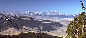
Lost River Range in Salmon-Challis National Forest
Usa edcp relief location map.png
Red pog.svg
Location Idaho, United States
Nearest city Salmon, Idaho
Coordinates 45°16′54″N114°11′45″W / 45.28167°N 114.19583°W / 45.28167; -114.19583 Coordinates: 45°16′54″N114°11′45″W / 45.28167°N 114.19583°W / 45.28167; -114.19583
Area 4,235,940 acres (17,142.2 km2)
Established July 1, 1908
Governing body U.S. Forest Service
Website Salmon-Challis National Forest

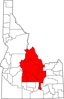
Salmon-Challis National Forest is located in east central sections of the U.S. state of Idaho. At 4,235,940 acres (6,618.66 sq mi, or 17,142.24 km2) it is one of the largest national forests in the lower 48 states and also has most of the land area of the Frank Church River of No Return Wilderness, which is the largest wilderness area south of Alaska. Borah Peak, the tallest mountain in Idaho, is also found here. The Wild and Scenic Salmon River weaves through the rugged terrain of the Sawtooth Mountains and Sawtooth National Recreation Area, while it flows for over 75 miles (121 km) through the forest. The Big Lost River has its headwaters within the national forest.

U.S. state constituent political entity sharing sovereignty as the United States of America

In the United States, a state is a constituent political entity, of which there are currently 50. Bound together in a political union, each state holds governmental jurisdiction over a separate and defined geographic territory and shares its sovereignty with the federal government. Due to this shared sovereignty, Americans are citizens both of the federal republic and of the state in which they reside. State citizenship and residency are flexible, and no government approval is required to move between states, except for persons restricted by certain types of court orders. Four states use the term commonwealth rather than state in their full official names.

Idaho State of the United States of America

Idaho is a state in the northwestern region of the United States. It borders the state of Montana to the east and northeast, Wyoming to the east, Nevada and Utah to the south, and Washington and Oregon to the west. To the north, it shares a small portion of the Canadian border with the province of British Columbia. With a population of approximately 1.7 million and an area of 83,569 square miles (216,440 km2), Idaho is the 14th largest, the 12th least populous and the 7th least densely populated of the 50 U.S. states. The state's capital and largest city is Boise.

Acre unit of area

The acre is a unit of land area used in the imperial and US customary systems. It is traditionally defined as the area of one chain by one furlong, which is exactly equal to 10 square chains, ​1640 of a square mile, or 43,560 square feet, and approximately 4,047 m2, or about 40% of a hectare. Based upon the International yard and pound agreement of 1959, an acre may be declared as exactly 4,046.8564224 square metres. The acre is a statute measure in the United States and was formerly one in the United Kingdom and almost all countries of the former British Empire, although informal use continues.

Contents

Challis National Forest, the more southerly of its two parts, lies primarily in Custer County, but also has major areas in Lemhi and Butte counties, as well as smaller areas in Clark and Blaine counties. It has a total area of 2,463,471 acres (3,849.17 sq mi, or 9,969.31 km2). There are local ranger district offices located in Challis, Clayton, and Mackay.

Custer County, Idaho county in Idaho

Custer County is a rural mountain county in the center of the U.S. state of Idaho. As of the 2010 census, the population was 4,368. The county seat is Challis. Established in 1881, the county was named for the General Custer Mine, where gold was discovered five years earlier. Custer County relies on ranching, mining, and tourism as its main resources.

Lemhi County, Idaho county in Idaho, United States

Lemhi County is a county located in the U.S. state of Idaho. As of the 2010 census, the population was 7,936. The largest city and county seat is Salmon. The county was established in 1869, named after Fort Lemhi, a remote Mormon missionary settlement from 1855–58 in Bannock and Shoshone territory.

Butte County, Idaho county in Idaho, USA

Butte County is a rural county located in the U.S. state of Idaho. As of the 2010 census, the population was 2,891, making it the third-least populous county in Idaho. Its county seat and largest city is Arco. The county was established in 1917 from parts of Bingham, Blaine, and Jefferson counties. The county gained territory in the Clyde area from Custer County in 1937 to reach its present boundary.

Salmon National Forest, which lies to the north, is primarily located in Lemhi County, with spillover into Valley and Idaho counties. It has a total area of 1,772,469 acres (2,769.48 sq mi, or 7,172.93 km2). [1] There are local ranger district offices located in Leadore, North Fork, and Salmon.

Valley County, Idaho county in Idaho, United States

Valley County is a rural county located in the U.S. state of Idaho. As of the 2010 census, the population was 9,862. The county seat is Cascade, and the largest city is McCall.

Idaho County, Idaho county in Idaho, United States

Idaho County is a county in the U.S. state of Idaho. As of the 2010 census, the population was 16,267. The county seat is Grangeville. Previous county seats of the area were Florence (1864–68), Washington (1868–75), and Mount Idaho (1875–1902).

Leadore, Idaho City in Idaho, United States

Leadore is an incorporated village of the State of Idaho in Lemhi County, Idaho, United States. The population was 70 in the 1990 census, 90 in the 2000 census. The population was 105 at the 2010 census.

The combined forest headquarters are located in Salmon, Idaho.

Salmon, Idaho City in Idaho, United States

Salmon is a city in Lemhi County, Idaho, United States. The population was 3,112 at the 2010 census. The city is the county seat of Lemhi County.

Wilderness areas

A map of Salmon-Challis National Forest SalmonChallisNFMap.jpg
A map of Salmon-Challis National Forest

There are two officially designated wilderness areas within Salmon-Challis National Forest that are part of the National Wilderness Preservation System. Both extend into neighboring National Forests or onto lands of the Bureau of Land Management.

A wilderness area is a region where the land is in a natural state; where impacts from human activities are minimal—that is, as a wilderness. It might also be called a wild or natural area. Especially in wealthier, industrialized nations, it has a specific legal meaning as well: as land where development is prohibited by law. Many nations have designated Wilderness Areas, including Australia, Canada, New Zealand, South Africa and the United States.

National Wilderness Preservation System

The National Wilderness Preservation System (NWPS) of the United States protects federally managed wilderness areas designated for preservation in their natural condition. Activity on formally designated wilderness areas is coordinated by the National Wilderness Preservation System. Wilderness areas are managed by four federal land management agencies: the National Park Service, the U.S. Forest Service, the U.S. Fish and Wildlife Service, and the Bureau of Land Management. The term "wilderness" is defined as "an area where the earth and community of life are untrammeled by man, where man himself is a visitor who does not remain" and "an area of undeveloped Federal land retaining its primeval character and influence, without permanent improvements or human habitation, which is protected and managed so as to preserve its natural conditions." As of 2016, there are 765 designated wilderness areas, totaling 109,129,657 acres (44,163,205 ha), or about 4.5% of the area of the United States.

Bureau of Land Management agency within the United States Department of the Interior

The Bureau of Land Management (BLM) is an agency within the United States Department of the Interior that administers more than 247.3 million acres (1,001,000 km2) of public lands in the United States which constitutes one-eighth of the landmass of the country. President Harry S. Truman created the BLM in 1946 by combining two existing agencies: the General Land Office and the Grazing Service. The agency manages the federal government's nearly 700 million acres (2,800,000 km2) of subsurface mineral estate located beneath federal, state and private lands severed from their surface rights by the Homestead Act of 1862. Most BLM public lands are located in these 12 western states: Alaska, Arizona, California, Colorado, Idaho, Montana, Nevada, New Mexico, Oregon, Utah, Washington and Wyoming.

Payette National Forest U.S. national forest in Idaho

The Payette National Forest is a U.S. National Forest located in central western Idaho, in parts of Valley, Idaho, Adams, and Washington counties. The land area consists of approximately 2.3 million acres (9,300 km2) of federally managed lands. It is bordered by Hells Canyon National Recreation Area and the Hells Canyon to the west, Salmon-Challis National Forest to the east, Boise National Forest to the south, and the Nez Perce National Forest to the north. The Payette National Forest is a part of the Intermountain Region. It is under the jurisdiction of a forest supervisor in McCall and is divided into five ranger districts: McCall, Krassel, New Meadows, Council, and Weiser.

Boise National Forest national forest in the US state of Idaho

Boise National Forest is a National Forest covering 2,203,703 acres (8,918.07 km2) of the U.S. state of Idaho. Created on July 1, 1908, from part of Sawtooth National Forest, it is managed by the U.S. Forest Service as five units: the Cascade, Emmett, Idaho City, Lowman, and Mountain Home ranger districts.

Bitterroot National Forest

Bitterroot National Forest comprises 1.587 million acres (6,423 km²) in west-central Montana and eastern Idaho, of the United States. It is located primarily in Ravalli County, Montana, but also has acreage in Idaho County, Idaho (29.24%), and Missoula County, Montana (0.49%).

Related Research Articles

Salmon River (Idaho) river in Idaho in the Northwestern United States

The Salmon River is located in Idaho in the northwestern United States. The Salmon is also known as "The River of No Return". It flows for 425 miles (684 km) through central Idaho, draining a rugged, thinly populated watershed of 14,000 square miles (36,260 km2) and dropping more than 7,000 feet (2,130 m) between its headwaters, near Galena Summit above the Sawtooth Valley in the Sawtooth National Recreation Area, and its confluence with the Snake River. Measured at White Bird, its average discharge is 11,060 cubic feet (310 m3) per second. It is one of the largest rivers in the continental United States without a single dam on its mainstem.

Gifford Pinchot National Forest protected area in the state of Washington, United States

Gifford Pinchot National Forest is a National Forest located in southern Washington, USA, managed by the United States Forest Service. With an area of 1.32 million acres (5300 km2), it extends 116 km along the western slopes of Cascade Range from Mount Rainier National Park to the Columbia River. The forest straddles the crest of the South Cascades of Washington State, spread out over broad, old growth forests, high mountain meadows, several glaciers, and numerous volcanic peaks. The forest's highest point is at 12,276 ft. at the top of Mount Adams, the second tallest volcano in the state after Rainier. It includes the 110,000-acre (450 km2) Mount St. Helens National Volcanic Monument, established by Congress in 1982

Nez Perce National Forest

The Nez Perce National Forest is a 2,224,091-acre (9,000.58 km2) United States National Forest located in west-central Idaho. The forest is bounded on the east by the state of Montana, on the north by the Clearwater National Forest, on the west by a portion of the Wallowa–Whitman National Forest and on the south by the Payette National Forest.

Frank Church–River of No Return Wilderness

The Frank Church—River of No Return Wilderness Area is a protected wilderness area in Idaho. It was created in 1980 by the United States Congress and renamed in 1984 as the Frank Church-River of No Return Wilderness Area in honor of U.S. Senator Frank Church.

Beaverhead-Deerlodge National Forest forest in Montana, United States

The Beaverhead-Deerlodge National Forest is the largest of the National Forests in Montana, United States. Covering 3.36 million acres (13,600 km2), the forest is broken into nine separate sections and stretches across eight counties in the southwestern area of the state. President Theodore Roosevelt named the two forests in 1908 and they were merged in 1996. Forest headquarters are located in Dillon, Montana. In Roosevelt's original legislation, the Deerlodge National Forest was called the Big Hole Forest Reserve. He created this reserve because the Anaconda Copper Mining Company, based in Butte, Montana, had begun to clearcut the upper Big Hole River watershed. The subsequent erosion, exacerbated by smoke pollution from the Anaconda smelter, was devastating the region. Ranchers and conservationists alike complained to Roosevelt, who made several trips to the area. (Munday 2001)

Klamath National Forest

Klamath National Forest is a 1,737,774-acre national forest, in the Klamath Mountains, located in Siskiyou County in northern California, but with a tiny extension into southern Jackson County in Oregon. The forest contains continuous stands of ponderosa pine, Jeffrey pine, Douglas fir, red fir, white fir and incense cedar. Old growth forest is estimated to cover some 168,000 acres (680 km2) of the forest land. Forest headquarters are located in Yreka, California. There are local ranger district offices located in Fort Jones, Happy Camp, and Macdoel, all in California. Klamath was established on May 6, 1905. This park includes the Kangaroo Lake and the Sawyers Bar Catholic Church is located within the boundaries of the Forest.

Sawtooth Wilderness a wilderness area in the US state of Idaho

The Sawtooth Wilderness is a federally-protected wilderness area that covers 217,088 acres (87,852 ha) of the state of Idaho. Managed by the U.S. Forest Service in the U.S. Department of Agriculture, it was designated the Sawtooth Primitive Area in 1937 to preserve the exceptional scenic beauty of the Sawtooth Mountains. On August 22, 1972 Public Law 92-400 designated the Primitive Area as the Sawtooth Wilderness and part of the newly created Sawtooth National Recreation Area. As part of the National Wilderness Preservation System, the Sawtooth Wilderness is an area where human development and use are restricted and people are to remain only visitors. According to the United States Environmental Protection Agency, the Sawtooth Wilderness has some of the clearest air in the lower 48 states.

Sawtooth National Forest A national forest located in the US states of Idaho and Utah

Sawtooth National Forest is a National Forest that covers 2,110,408 acres in the U.S. states of Idaho and Utah. Managed by the U.S. Forest Service in the U.S. Department of Agriculture, it was originally named the Sawtooth Forest Reserve in a proclamation issued by President Theodore Roosevelt on May 29, 1905. On August 22, 1972 a portion of the forest was designated as the Sawtooth National Recreation Area (SNRA), which includes the Sawtooth, Cecil D. Andrus–White Clouds, and Hemingway–Boulders wilderness areas. The forest is managed as four units: the SNRA and the Fairfield, Ketchum, and Minidoka Ranger Districts.

Gunnison National Forest U.S. National Forest in Mesa, Gunnison, Hinsdale and Saguache Counties in Western part of the U.S. state of Colorado

The Gunnison National Forest is a U.S. National Forest covering 1,672,136 acres in Mesa, Gunnison, Hinsdale and Saguache Counties in Western part of the U.S. state of Colorado. It borders the White River National Forest to the north, the Grand Mesa and Uncompahgre National Forests to the west, the San Isabel National Forest to the east and the Rio Grande National Forest to south. It lies in parts of five counties. In descending order of land area within the forest they are Gunnison, Saguache, Hinsdale, Delta, and Montrose counties.

Central Idaho region of the state of Idaho, USA

Central Idaho is a geographical term for the region located northeast of Boise and southeast of Lewiston in the U.S. state of Idaho. It is dominated by federal lands administered by the United States Forest Service and the Bureau of Land Management. Idaho's tallest mountain, Borah Peak, is located in this region. A large part of the Sawtooth National Recreation Area is within Central Idaho.

Stripe Mountain mountain in United States of America

Stripe Mountain is the highest point in both the South Clearwater Mountains and the Clearwater Mountains as a whole, part of the Bitterroot Range and Rocky Mountains in the panhandle of Idaho in the Western United States. Its summit is at an elevation of 9,001 ft (2,744 m) and the mountain's ridgeline forms the boundary of Idaho County and Lemhi County. The Idaho County portion of the mountain lies within the Bitterroot National Forest and the Lemhi County portion of the mountain lies within the Salmon-Challis National Forest, and the entirety of the mountain lies within the Frank Church-River of No Return Wilderness Area.

Sawtooth Range (Idaho) mountain range in the US state of Idaho

The Sawtooth Range is a mountain range of the Rocky Mountains in central Idaho, United States, reaching a maximum elevation of 10,751 feet (3,277 m) at the summit of Thompson Peak. It encompass an area of 678 square miles (1,756 km2) spanning parts of Custer, Boise, Blaine, and Elmore counties, and is bordered to the east by the Sawtooth Valley. Much of the mountain range is within the Sawtooth Wilderness, part of the Sawtooth National Recreation Area and Sawtooth National Forest.

Mount Cramer mountain in United States of America

Mount Cramer, at 10,716 feet (3,266 m) is the second highest peak in the Sawtooth Range of Idaho. The summit of Mount Cramer is located on the border of Custer and Boise Counties. The peak is the highest point in Boise County. Mount Cramer is also located within the Sawtooth Wilderness portion of the Sawtooth National Recreation Area. The town of Stanley, Idaho is almost 14 miles (23 km) from Mount Cramer, while the area known as Sawtooth City is nearly 12 miles (19 km) from Mount Cramer. The west side of Mount Cramer drains into the South Fork of the Payette River, while the east side drains to the Salmon River.

Banner Creek Summit

Banner Creek Summit is a mountain pass in central Idaho, at an elevation of 7,037 feet (2,145 m) above sea level on State Highway 21, the Ponderosa Pine Scenic Byway. It is located on the border of Custer County and Boise County, also the border of the Challis and Boise National Forests, immediately northwest of the Sawtooth Range.

Idaho State Highway 21 is the Ponderosa Pine Scenic Byway, primarily a two-lane highway from Boise to Stanley. With two-thirds of its length in Boise County, it passes by historic Idaho City and the village of Lowman to the western edge of the Sawtooth Mountains, then along their northern boundary to Stanley.

Payette Peak mountain in United States of America

Payette Peak, at 10,221 feet (3,115 m) above sea level is a peak in the Sawtooth Range of Idaho. The peak is located in the Sawtooth Wilderness of Sawtooth National Recreation Area on the border of Boise and Custer counties. The peak is located 1.33 mi (2.14 km) south of Mount Cramer, its line parent. Payette Peak rises above the southwest end of Hidden Lake.

References