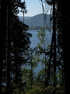
Benewah County is a county located in the northwest part of the U.S. state of Idaho. As of the 2020 United States Census the county had a population of 9,530. The county seat and largest city is St. Maries, which has some area inside the Coeur d'Alene Reservation.

Coeur d'Alene is a city and the county seat of Kootenai County, Idaho, United States. It is the largest city in North Idaho and the principal city of the Coeur d'Alene Metropolitan Statistical Area. At the 2020 census the city's population was 54,628. Coeur d'Alene is a satellite city of Spokane, which is located about thirty miles (50 km) to the west in the state of Washington. The two cities are the key components of the Spokane–Coeur d'Alene Combined Statistical Area, of which Coeur d'Alene is the third-largest city. The city is situated on the north shore of the 25-mile (40 km) long Lake Coeur d'Alene and to the west of the Coeur d'Alene Mountains. Locally, Coeur d'Alene is known as the "Lake City," or simply called by its initials, "CDA."

Farragut State Park is a public recreation area located at the southern tip of Lake Pend Oreille in the Coeur d'Alene Mountains of the Idaho Panhandle in the northwest United States. The 4,000-acre (1,600 ha) state park is five miles (8 km) east of Athol in Kootenai County, about thirty miles (50 km) northeast of Coeur d'Alene. Activities include camping, picnicking, hiking, mountain biking, cycling, fishing, boating, swimming, water sports, orienteering, disc golf, flying model aircraft, archery, and horseback riding.

The Coeur d'Alene Tribe are a Native American tribe and one of five federally recognized tribes in the state of Idaho.

The Coeur d'Alene Reservation is a Native American reservation in northwestern Idaho, United States. It is home to the federally recognized Coeur d'Alene, one of the five federally recognized tribes in the state.
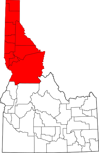
The Idaho Panhandle—locally known as North Idaho—is a salient region of the U.S. state of Idaho encompassing the state's 10 northernmost counties: Benewah, Bonner, Boundary, Clearwater, Idaho, Kootenai, Latah, Lewis, Nez Perce, and Shoshone. The Panhandle is bordered by the state of Washington to the west, Montana to the east, and the Canadian province of British Columbia to the north. The Idaho panhandle, along with Eastern Washington, makes up the region known as the Inland Northwest, headed by its largest city, Spokane, Washington.

Lake Coeur d'Alene, officially Coeur d'Alene Lake, is a natural dam-controlled lake in North Idaho, located in the Pacific Northwest region of the United States. At its northern end is the city of Coeur d'Alene. It spans 25 miles (40 km) in length and ranges from 1 to 3 miles (5 km) wide with over 109 miles (175 km) of shoreline.

Weldon Brinton Heyburn was an American attorney and politician who served as a United States Senator from Idaho from 1903 to 1912.
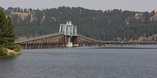
The Trail of the Coeur d'Alenes is a rail trail in the northwest United States, in northern Idaho. It follows the former Union Pacific Railroad right-of-way from Mullan, a mountain mining town near the Montana border, westward to Plummer, a town on the prairie near the Washington border. Generally following the Coeur d'Alene River, the rail line was abandoned in 1991, and the trail officially opened in March 2004.
Interstate 90 (I-90) is a transcontinental Interstate Highway that runs east–west across the northern United States. Within the state of Idaho, the freeway travels for 74 miles (119 km) from the Washington border near Spokane to Coeur d'Alene and the panhandle region at the north end of the state. After traveling through the Silver Valley along the Coeur d'Alene River in the Bitterroot Range, I-90 crosses into Montana at Lookout Pass.

Spokane, Washington has a rich sporting culture and the area residents are active in many spectator and participant sports. Although Spokane lacks any major, nationally recognized professional sports team, Spokane has a sports friendly atmosphere, and was recognized and rated #99 in the Sporting News 2006 "99 Best Sporting Cities" list. In 2009, Sports Business Journal rated Spokane as the fifth best minor league sports market in America out of 239 markets.

The Saint Joe River is a 140-mile (225 km) long tributary of Coeur d'Alene Lake in northern Idaho. Beginning at an elevation of 6,487 feet (1,977 m) in the Northern Bitterroot Range of eastern Shoshone County, it flows generally west through the Saint Joe River Valley and the communities of Avery and Calder. Past Calder, it flows into Benewah County and through the town of St. Maries, where it receives its largest tributary, the Saint Maries River. It then turns northwest, passing through Heyburn State Park before reaching its mouth just north of the Kootenai County line. Much of the river's route through Heyburn State Park is partially flooded due to raised water levels from the Washington Water Power dam at Post Falls on the Spokane River below Coeur d'Alene Lake. With a mouth elevation of 2,129 feet (649 m), it is claimed to be the highest navigable river in the world. Multiple rivers in Canada are both higher and navigable, including the Babine, and Middle Rivers.
State Highway 5 (SH-5) is a state highway in Benewah County, in the U.S. state of Idaho. It runs 19.108 miles (30.751 km) from U.S. Route 95 in Plummer, east to SH-3 in Saint Maries.

The North Idaho Centennial Trail is a 24 miles (39 km) paved trail in Idaho used for transportation and recreational activities. Extending from Higgens Point on the northeast side of Lake Coeur d'Alene, a popular place for bald eagle watchers in early winter, the trail follows the lake's north shoreline to the Spokane River where it follows it to the Idaho/Washington border. On the other side of the state border, the trail becomes the Spokane River Centennial Trail and extends for another 37 miles (60 km) out to Sontag Park in Nine Mile Falls, Washington. The trail passes through the towns of Post Falls, Idaho and Coeur d'Alene, Idaho.
Bayview is an unincorporated community in the northwest United States, located in Kootenai County, Idaho, north of Coeur d'Alene. On the southwest shore of Lake Pend Oreille, Bayview is seven miles (11 km) east-northeast of Athol. The community is served by State Highway 54 and a post office with ZIP code 83803; its approximate elevation is 2,100 feet (640 m) above sea level. Nearby is Farragut State Park, formerly the Farragut Naval Training Station, a major training facility during World War II.
Coeur d'Alene Parkway State Park is a 5.7-mile-long (9.2 km) paved trail in Kootenai County, Idaho, United States. The parkway is located south of Coeur d'Alene along the north shore of Lake Coeur d'Alene. It is a portion of the North Idaho Centennial Trail. Park features include a boat launch, docks, and picnic area at Higgens Point.
Coeur d'Alene River Wildlife Management Area at 5,799 acres (23.47 km2) is an Idaho wildlife management area primarily in Kooteani County but also in Benewah County. The majority of the WMA is located in the Thompson Lake Segment along the Coeur d'Alene River, but portions are also located along the St. Joe River in the upper sections of Lake Coeur d'Alene near Heyburn State Park. Land acquisition for the WMA began in 1964.
Idaho v. United States, 533 U.S. 262 (2001), was a United States Supreme Court case in which the Court held that the United States, not the state of Idaho, held title to lands submerged under Lake Coeur d'Alene and the St. Joe River, and that the land was held in trust for the Coeur d'Alene Tribe as part of its reservation, and in recognition of the importance of traditional tribal uses of these areas for basic food and other needs.
Circling Raven Golf Club is an 18-hole championship golf course in the northwest United States, located in northern Idaho near Worley. It was rated the third best public course in Idaho by Golf Digest in August 2015.

The Tubbs Hill Natural Area is a 165-acre (0.67 km2) public park and natural area in Coeur d'Alene, Idaho. The park is located on a peninsula, with Lake Coeur d'Alene bordering the park on its west, south, and east sides and McEuen Park to the north with its main entrance and trail head at 210 South 3rd Street. An additional trail head is located at the southern terminus of 10th Street. The parks main attraction is a 2.2-mile (3.5 km) Interpretive Trail that takes visitors passed scenic vantage points and natural and historical sites of interest. Other activities such as climbing, cliff jumping, kayaking, fishing, sun bathing, bird watching and flower viewing are also popular things to do in the park.
