Coeur d'Alene's Old Mission State Park is a heritage-oriented state park in northernIdaho in the western United States, preserving the Mission of the Sacred Heart, or Cataldo Mission, a national historic landmark. The park contains the church itself, the parish house, and the surrounding property. Built in 1850–1853, Mission of the Sacred Heart is the oldest standing building in Idaho.[4] It was designated a National Historic Landmark in 1961,[5] and put on the National Register of Historic Places in 1966.[6]
In 1831, the Nez Perce and Flathead people had heard of the Bible and wanted more information on Christianity. They sent six men east to St. Louis with four arriving, and in 1842, Father Pierre-Jean De Smet responded to the request and came to the area. Fr. Nicholas Point and Br. Charles Huet came and helped to pick a mission location. The first chosen was along the St. Joe River and was subject to flooding. In 1846, they moved it to its current location.
Example of the newspaper wallpaper and tin can metalwork
In 1850, the church was taken over by the Italian Jesuit missionary Antonio Ravalli, who began designing the new mission building. He had the building constructed by the Indians themselves, so they would feel part of the church. It was built using the wattle and daub method and finished some three years later without using nails.
The mission was named after the Sacred Heart of Jesus and the spot was renamed the Coeur d'Alene's Old Mission State Park by the Coeur d'Alene Tribe. A misnomer locally is to refer to the whole mission as the "Cataldo" Mission. This term cropped up in the area due to the fame of Father Joseph Cataldo (1837–1928), a Sicilian priest born in the village of Terrasini, who spent most of his missionary Jesuit life in the frontier community and founded Gonzaga University in Spokane. The nearest town to the mission is Cataldo. The mission became a stop and supply station for traders, settlers, and miners traveling on the Mullan Road. It was also a working port for boats heading up the Coeur d'Alene River.
In 1976, a major restoration of the church was chosen as Idaho State's Bicentennial Project to celebrate the nation's bicentennial.
Mission area
The Amelia Wheaton with the Old Mission in the background ca. 1885
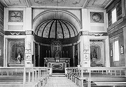
Church
The walls were decorated with fabric bought from the Hudson's Bay Company and a hand-painted newspaper from Philadelphia that Fr. Ravalli had received in the mail. Tin cans were used to create the idea of chandeliers. Both wooden statues were carved by Fr. Rivalli with a knife and were intended to look like marble. The blue coloring of the interior wood is pressed huckleberries stains.[citation needed]
Parish house
After being burned down, it was rebuilt in 1887. It is a two-story building, with the upstairs used for sleeping quarters. It contains a smaller chapel, mostly used for daily Mass.[citation needed]
State park
The surrounding property has two cemeteries, a nature trail, and a visitors center. The site became Old Mission State Park in 1975 through a long-term lease with the Roman Catholic Diocese of Boise.[3]
↑"Idaho State Parks Fast Facts"(PDF). Lesson 6: State Park by Design. Idaho Department of Parks and Recreation. Archived from the original(PDF) on January 31, 2017. Retrieved October 19, 2017.
This page is based on this Wikipedia article Text is available under the CC BY-SA 4.0 license; additional terms may apply. Images, videos and audio are available under their respective licenses.