
Mullan is a city in the northwest United States, located in the Silver Valley mining district of northern Idaho. The population was 646 at the 2020 census and 692 at the 2010 census, and 840 in 2000.

Fort Benton is a city in and the county seat of Chouteau County, Montana, United States. Established in 1846, Fort Benton is the oldest continuously occupied settlement in Montana. Fort Benton was the most upstream navigable port on the Mississippi River System, and is considered "the world’s innermost port".

Deer Lodge is a city in and the county seat of Powell County, Montana, United States. The population was 2,938 at the 2020 census.
The Inland Northwest, historically and alternatively known as the Inland Empire, is a region of the American Northwest centered on the Greater Spokane, Washington Area, encompassing all of Eastern Washington and North Idaho. Under broader definitions, Northeastern Oregon and Western Montana may be included in the Inland Northwest. Alternatively, stricter definitions may exclude Central Washington and Idaho County, Idaho.
There are many historic trails and roads in the United States which were important to the settlement and development of the United States including those used by American Indians.

The Palouse River is a tributary of the Snake River in Washington and Idaho, in the northwest United States. It flows for 167 miles (269 km) southwestwards, primarily through the Palouse region of southeastern Washington. It is part of the Columbia River Basin, as the Snake River is a tributary of the Columbia River.

Fort Walla Walla is a United States Army fort located in Walla Walla, Washington. The first Fort Walla Walla was established July 1856, by Lieutenant Colonel Edward Steptoe, 9th Infantry Regiment. A second Fort Walla Walla was occupied September 23, 1856. The third and permanent military Fort Walla Walla was built in 1858 and adjoined Steptoeville, now Walla Walla, Washington, a community that had grown up around the second fort. An Executive Order on May 7, 1859 declared the fort a military reservation containing 640 acres devoted to military purposes and a further 640 acres each of hay and timber reserves. On September 28, 1910 soldiers from the 1st Cavalry lowered the flag closing the fort. In 1917, the fort briefly reopened to train men of the First Battalion Washington Field Artillery in support of action in World War I. In 1921, the fort and property were turned over to the Veterans Administration where 15 original buildings from the military era remain. Today, the complex contains a park, a museum, and the Jonathan M. Wainright Memorial VA Medical Center.

State Route 26 (SR 26) is a state highway in central Washington in the United States. It travels east–west for 114 miles (183 km) from Interstate 90 (I-90) near Vantage to U.S. Route 195 (US 195) in Colfax. The highway intersects several major north–south highways, including SR 24, SR 17, US 395, and SR 261 before ending in Colfax. The route serves as a connector between Vantage, Royal City, Othello, Washtucna, La Crosse, and Colfax.
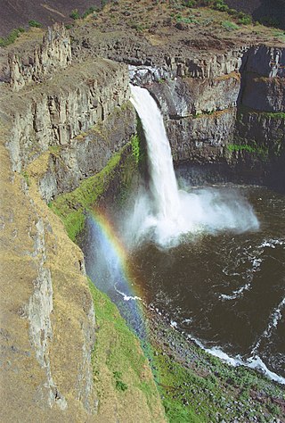
Palouse Falls is a waterfall in the northwest United States on the Palouse River, about four miles (6 km) upstream of its confluence with the Snake River in southeast Washington. Within the 94-acre (38 ha) Palouse Falls State Park, the falls are 200 feet (61 m) in height, and consist of an upper fall with a drop around twenty feet (6 m), which lies 1,000 feet (300 m) north-northwest of the main drop, and a lower fall.
Lookout Pass is a mountain pass in the Rocky Mountains of the northwestern United States. In the Coeur d'Alene Mountains of the Bitterroot Range, the pass is on the border between Idaho and Montana, traversed by Interstate 90 at an elevation of 4,710 feet (1,436 m) above sea level.

State Route 125 (SR 125) is a state highway in Walla Walla County, Washington, United States. It travels 24 miles (39 km) south from the city of Walla Walla to the Oregon state border and north to a junction with SR 124 near Prescott. The highway continues south towards Pendleton, Oregon, as OR 11. SR 125 also has a spur route in Walla Walla that connects it to an interchange with U.S. Route 12 (US 12).

Interstate 90 (I-90) is a transcontinental Interstate Highway that runs east–west across the northern United States. Within the state of Idaho, the freeway travels for 74 miles (119 km) from the Washington border near Spokane to Coeur d'Alene and the panhandle region at the north end of the state. After traveling through the Silver Valley along the Coeur d'Alene River in the Bitterroot Range, I-90 crosses into Montana at Lookout Pass.
Fourth of July Summit is a mountain pass in the Rocky Mountains of the northwestern United States, located in northern Idaho. Its elevation is 3,081 feet (939 m) above sea level on Interstate 90 in central Kootenai County, east of the city of Coeur d'Alene.

John Mullan Jr. was an American soldier, explorer, civil servant, and road builder. After graduating from the United States Military Academy in 1852, he joined the Northern Pacific Railroad Survey, led by Isaac Stevens. He extensively explored western Montana and portions of southeastern Idaho, discovered Mullan Pass, participated in the Coeur d'Alene War, and led the construction crew which built the Mullan Road in Montana, Idaho, and Washington state between the spring of 1859 and summer of 1860.
The history of Missoula, Montana begins as early as 12,000 years ago with the end of the region's glacial lake period with western exploration dating back to the Lewis and Clark Expedition of 1804–1806. The first permanent settlement was founded in 1860.
This is a timeline of pre-statehood Montana history comprising substantial events in the history of the area that would become the State of Montana prior to November 8, 1889. This area existed as Montana Territory from May 28, 1864, until November 8, 1889, when it was admitted to the Union as the State of Montana.
Hardy Bridge is a Warren through truss, three-span, two-lane bridge in the western United States. It crosses the Missouri River and is located at milepost 6 on Old U.S. Route 91, about fourteen miles (23 km) southwest of Cascade, Montana, which is southwest of Great Falls.
The Fort Walla Walla–Fort Colville Military Road was built in June 1859 to connect the Walla Walla area with its fairly easy access to the Columbia River to the mountainous area of the Huckleberry and Selkirk Mountains of current Northeast Washington and the Inland Northwest. Brigadier General William S. Harney, commander of the Department of Oregon, opened up the district north of the Snake River to settlers in 1858 and ordered Brevet Major Pinkney Lugenbeel, 9th Infantry Regiment to establish a U.S. Army post to restrain the Indians perceived as hostile to the U.S. Army's Northwest Division and to protect miners who traveled to the area after first reports of gold in the area appeared in Western Washington newspapers in July 1855.

Tower Rock State Park is a state park near the community of Cascade in the U.S. state of Montana in the United States. The centerpiece of the park is Tower Rock, a 424-foot (129 m)-high rock formation which marks the entrance to the Missouri River Canyon in the Adel Mountains Volcanic Field. It was well known to Native Americans, and considered a sacred place by the Piegan Blackfeet. Tower Rock received its current name when Meriwether Lewis of the Lewis and Clark Expedition visited the site in 1805. Railroad and highway development in the late 1800s and 1900s skirted Tower Rock, but the landform itself remained pristine. The 87.2 acres (0.353 km2) encompassing Tower Rock was added to the National Register of Historic Places on March 18, 2002. The 140-acre (0.57 km2) Tower Rock State Park was created around the National Historic Site in 2004.


