Bearmouth is a former town located in Granite County, Montana, USA. It began as a trading post for the placer mining camps of Beartown, Garnet and Coloma, located in the hills north of Bearmouth in Granite County. A pioneer family named Lannen operated the gold exchange and ferry boat across the Clark Fork River.[2]
Bearmouth was not a mining camp, but rather a town that depended on the survival of other towns that were mining camps. During the late 19th century, enormously rich ores from Garnet were brought into Bearmouth to be shipped to smelters. When Garnet ceased to exist, Bearmouth followed suit. The town, however, was also a main stop for stagecoaches on the old Mullan Road. As such, it had a two-storied, balconied inn for travelers to spend the night as well as a large livery stable, both of which still stand.
The nearest town is Drummond, approximately 8 miles (13km) to the east. The nearest large city is Missoula, about 40 miles (64km) to the west. The next large city to the east is Butte, 80 miles (130km) to the southeast.
The Hazel Marsh Papers[3] is a collection of records from the many Lannen family businesses in Bearmouth. The post office, saloon, and general store ledger books are in the collection as well as financial records and legal documents from Christopher Lannen. School district records and voter registrations from Bearmouth are also in the collection. The collection also contains photographs and memorabilia and is located at the Maureen and Mike Mansfield Library, K. Ross Toole Archives, University of Montana.
Missoula County is a county located in the State of Montana. As of the 2020 census, the population was 117,922, making it Montana's third most populous county. Its county seat and most populous city is Missoula. The county was founded in 1860. Missoula County comprises the Missoula, MT Metropolitan Statistical Area, and is not a consolidated city-county.
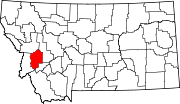
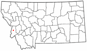
Granite County is a county located in the U.S. state of Montana. As of the 2020 census, the population was 3,309. Its county seat is Philipsburg. The county was founded in 1893, and was named for a mountain which contains the Granite Mountain silver mine.
Scouting in Montana has a long history, from the 1910s to the present day, serving thousands of youth in programs that suit the environment in which they live.
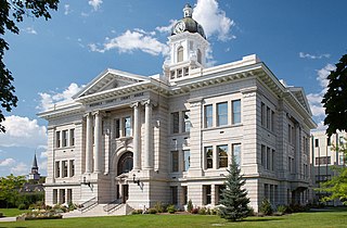
Philipsburg is a town in and the county seat of Granite County, Montana, United States. The population was 841 at the 2020 census. The town was named after the famous mining engineer Philip Deidesheimer, who designed and supervised the construction of the ore smelter around which the town originally formed. He platted the townsite in 1867.
Bonner-West Riverside is a census-designated place (CDP) in Missoula County, Montana, United States, including the unincorporated communities of Bonner, Milltown, West Riverside, and Pinegrove. It is part of the Missoula metropolitan area. The population was 1,690 at the 2020 census.
Missoula is a city in and the county seat of Missoula County, Montana, United States. It is located along the Clark Fork River near its confluence with the Bitterroot and Blackfoot rivers in western Montana and at the convergence of five mountain ranges, and thus it is often described as the "hub of five valleys". The 2020 United States census recorded the city's population at 73,489 and the population of the Missoula Metropolitan Area at 117,922. As of 2023, the estimated city population was 77,757. Missoula is the second largest city and third largest metropolitan area in Montana. Missoula is home to the University of Montana, a public research university.
Deer Lodge is a city in and the county seat of Powell County, Montana, United States. The population was 2,938 at the 2020 census.
Basin is an unincorporated community and census-designated place (CDP) in Jefferson County, Montana, United States. It lies approximately 10 miles (16 km) southeast of the Continental Divide in a high narrow canyon along Interstate 15 about halfway between Butte and Helena. Basin Creek flows roughly north to south through Basin and enters the Boulder River on the settlement's south side. The population was 212 at the 2010 census, down from 255 at the 2000 census.
The Clark Fork, or the Clark Fork of the Columbia River, is a river in the U.S. states of Montana and Idaho, approximately 310 miles (500 km) long. It is named after William Clark of the 1806 Lewis and Clark Expedition. The largest river by volume in Montana, it drains an extensive region of the Rocky Mountains in western Montana and northern Idaho in the watershed of the Columbia River. The river flows northwest through a long valley at the base of the Cabinet Mountains and empties into Lake Pend Oreille in the Idaho Panhandle. The Pend Oreille River in Idaho, Washington, and British Columbia, Canada which drains the lake to the Columbia in Washington, is sometimes included as part of the Clark Fork, giving it a total length of 479 miles (771 km), with a drainage area of 25,820 square miles (66,900 km2). In its upper 20 miles (32 km) in Montana near Butte, it is known as Silver Bow Creek. Interstate 90 follows much of the upper course of the river from Butte to Saint Regis. The highest point within the river's watershed is Mount Evans at 10,641 feet (3,243 m) in Deer Lodge County, Montana along the Continental Divide.
The Bitterroot Valley is located in southwestern Montana, along the Bitterroot River between the Bitterroot Range and Sapphire Mountains, in the Northwestern United States.
Bannack is a ghost town in Beaverhead County, Montana, United States, located on Grasshopper Creek, approximately 11 miles (18 km) upstream from where Grasshopper Creek joins with the Beaverhead River south of Dillon. Founded in 1862, the town is a National Historic Landmark managed by the state of Montana as Bannack State Park.
Lolo National Forest is a national forest located in western Montana, United States with the western boundary being the state of Idaho. The forest spans 2 million acres (8,000 km2) and includes four wilderness areas; the Scapegoat and the Selway-Bitterroot Wilderness are partially within the forest while the Welcome Creek and Rattlesnake Wildernesses are solely in Lolo National Forest. The forest was created in 1906 from 4 different previous forests which were combined for administrative purposes. Lolo National Forest is west of the Continental divide and has a biodiversity influenced by both continental and maritime weather creating a transitional forest that has a high number of different plant and tree species.
Garnet is a ghost town in Granite County, Montana, United States. A thriving mining town in the 1890s, Garnet's population declined when local hard rock mines closed. The remaining buildings have been preserved and are open to visitors. The site is managed by the Bureau of Land Management.
Babb is a small unincorporated farming and ranching community in Glacier County, Montana, United States, on the Blackfeet Indian Reservation. The community experiences a large influx of tourists in the summer months as it is the gateway to the Many Glacier area of Glacier National Park. For statistical purposes, the United States Census Bureau has defined Babb as a census-designated place (CDP). It had a population of 174 at the 2010 census.
Interstate 90 (I-90) is an east–west transcontinental Interstate Highway across the northern United States, linking Seattle to Boston. The portion in the state of Montana is 552.54 miles (889.23 km) in length, passing through 14 counties in central and southern Montana. It is the longest segment of I-90 within a single state.
Condon is an unincorporated community and census-designated place in Missoula County, Montana, United States. Located along the Swan River and Montana Highway 83, Condon is situated between the Swan Range to the east and the Mission Mountains to the west, providing ready access to the Bob Marshall Wilderness and Mission Mountains Wilderness, respectively. Its population was 285 as of the 2020 United States census, down from 343 in 2010.
Coloma is a ghost town located in the area of the Garnet Range in Missoula County, Montana, United States. Little is known about the settlement, which appears to have been founded in 1893. Records of the period indicate high gold mining activity from 1896 onwards, with an estimated $200,000 to $250,000 in gold being extracted. In 1916, there was additional activity when a mill was built on the site and additional surveys on the ore veins were conducted, apparently without success. Additional prospecting activity occurred between 1932 and 1950.
Saltese is an unincorporated community and census-designated place in Mineral County, Montana, United States. It lies in the valley of the St. Regis River along Interstate 90 at exit 10. As of the 2020 census, the population was 10.
Francis Lyman Worden was a founder and prominent businessman of Missoula, Montana.
This page is based on this Wikipedia article Text is available under the CC BY-SA 4.0 license; additional terms may apply. Images, videos and audio are available under their respective licenses.