
The Bitterroot Valley is located in southwestern Montana, along the Bitterroot River between the Bitterroot Range and Sapphire Mountains, in the Northwestern United States.
The Bitterroot Valley is located in southwestern Montana, along the Bitterroot River between the Bitterroot Range and Sapphire Mountains, in the Northwestern United States.
The valley extends approximately 95 miles (153 km) from Lost Trail Pass in Idaho, where it is narrow, to a point near the city of Missoula along Interstate 90 where it is wider and flatter. To the west is the Bitterroot Range and its large Selway-Bitterroot Wilderness Area, and to the east is the smaller Sapphire Mountains and their Anaconda-Pintler Wilderness Area. The Bitterroot Range has steep faces, deep canyons, is heavily forested, and is within the Bitterroot National Forest. The Sapphire Mountains are more rounded, drier, and much less forested. [1]
The southern end of the valley is split into the East and West Forks of the Bitterroot River, and the northern end has the confluence of the Bitterroot River with the Clark Fork River. Connecting into the west side of the valley are numerous deeply carved granite canyons, including scenic Blodgett Canyon and Lolo Creek's canyon.
The vegetation in the valley has been significantly transformed. Originally it was covered in sagebrush. [2]
Highway 93 runs through the center of the valley, exiting to the south over 7,014 feet (2,138 m) Lost Trail Pass. U.S. Highway 93 is the main travel choice through the Bitterroot Valley, but the East Side Highway also runs through the valley, although it is much less traveled.
Communities within the valley include: Lolo in Missoula County; and Florence, Stevensville, Victor, Corvallis, Hamilton, Darby, Conner, and Sula in Ravalli County.
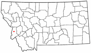
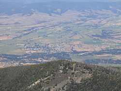
Hamilton, the largest town and the county seat of Ravalli County, is located at 46°14.8'N and 114°09.6'W at an elevation of 3,570 feet (1,090 m) with a population of 12,000. Business opportunities within these cities include manufacturing, agriculture, craft breweries, wineries, recreational services, and many entrepreneurs. [3]

The valley was the ancestral home of the Bitterroot Salish tribe of the Flathead nation. [4]
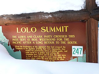
In early September 1805, the Lewis and Clark Expedition crossed Lost Trail Pass from present-day Idaho in order to connect with the overland route through the Rocky Mountains. Passing down Camp Creek and the East Fork, they followed the Bitterroot River northward to the point where it connects with the Nez Perce Trail and Lolo Creek. Before continuing their difficult journey to the west, they named their camp Traveler's Rest. Returning to this site in early July of the following year, they split their Corps of Discovery, furthering their explorations both to the northeast (Lewis) and to the south (Clark). [5]
In 1841, Jesuit priests led by Pierre-Jean De Smet founded St. Mary's Mission near present-day Stevensville. It was the first permanent white settlement in what is now Montana. [6] Fort Owen was established nearby in 1850, and difficult relations occurred between the white settlers and the Salish until 1891, when the native tribes were forcibly relocated to the Flathead Indian Reservation. [4] In 1877, Chief Joseph and the Nez Perce tribe passed south through the Bitterroot Valley, fleeing the U.S. Army. They exited the East Fork via Gibbons Pass, near where they fought at the Battle of the Big Hole.
The Bitterroot Valley had nearly a million apple trees in the early 1900s, and was one of the world's largest producers of MacIntosh apples at that time. Irrigation was provided by about 80 miles (130 km) of canals. Although the Bitterroot Valley's orchards became less competitive with apple orchards in Washington state after hailstorms in 1922 and 1923, it is still home to one of the nation's largest cider orchards. [7]
Settlement has continued since that time. The population of Ravalli County in the 2000 census was 36,070; 40,212 in the 2010 census. [8] The major industries are ranching, agriculture, forestry, and tourism.
The Bitterroot Valley offers many recreational activities, including: hiking, backpacking, mountain biking, and rock climbing in the surrounding mountains; and birding and fishing along the Bitterroot River. The valley is popular with hunters, for big game, upland birds, and waterfowl. [9]
The Bitterroot Valley is mentioned as the protagonist's birthplace in the song "Wild Montana Skies," from John Denver's album It's About Time (1983). [10]
The valley is the primary shooting location of the TV series Yellowstone .

Ravalli County is a county in the southwestern part of the U.S. state of Montana. As of the 2020 census, the population was 44,174. Its county seat is Hamilton.

Stevensville is a town in Ravalli County, Montana, United States. The population was 2,002 at the 2020 census.

The Flathead Indian Reservation, located in western Montana on the Flathead River, is home to the Bitterroot Salish, Kootenai, and Pend d'Oreilles tribes – also known as the Confederated Salish and Kootenai Tribes of the Flathead Nation. The reservation was created through the July 16, 1855, Treaty of Hellgate.
Lolo Pass, elevation 5,233 feet (1,595 m), is a mountain pass in the western United States, in the Bitterroot Range of the northern Rocky Mountains. It is on the border between the states of Montana and Idaho, approximately forty miles (65 km) west-southwest of Missoula, Montana.

The Nez Perce National Forest is a 4,000,000-acre (16,000 km2) United States National Forest located in west-central Idaho. The forest is bounded on the east by the state of Montana, on the north by the Clearwater National Forest, on the west by a portion of the Wallowa–Whitman National Forest and on the south by the Payette National Forest.

Clearwater National Forest with headquarters on the Nez Perce Reservation at Kamiah is located in North Central Idaho in the northwestern United States. The forest is bounded on the east by the state of Montana, on the north by the Idaho Panhandle National Forest, and on the south and west by the Nez Perce National Forest and Palouse Prairie.

The Battle of the Big Hole was fought in Montana Territory, August 9–10, 1877, between the United States Army and the Nez Perce tribe of Native Americans during the Nez Perce War. Both sides suffered heavy casualties. The Nez Perce withdrew in good order from the battlefield and continued their long fighting retreat that would result in their attempt to reach Canada and asylum.

The Bitterroot River is a northward flowing 84-mile (135 km) river running through the Bitterroot Valley, from the confluence of its West and East forks near Conner in southern Ravalli County to its confluence with the Clark Fork River near Missoula in Missoula County, in western Montana. The Clark Fork River is tributary to the Columbia River and ultimately, the Pacific Ocean. The Bitterroot River is a Blue Ribbon trout fishery with a healthy population of native westslope cutthroat trout and bull trout. It is the third most fly fished river in Montana behind the Madison and Big Horn Rivers.

Bitterroot National Forest comprises 1.587 million acres (6,423 km²) in west-central Montana and eastern Idaho, of the United States. It is located primarily in Ravalli County, Montana, but also has acreage in Idaho County, Idaho (29.24%), and Missoula County, Montana (0.49%).

Lolo National Forest is a national forest located in western Montana, United States with the western boundary being the state of Idaho. The forest spans 2 million acres (8,000 km2) and includes four wilderness areas; the Scapegoat and the Selway-Bitterroot Wilderness are partially within the forest while the Welcome Creek and Rattlesnake Wildernesses are solely in Lolo National Forest. The forest was created in 1906 from 4 different previous forests which were combined for administrative purposes. Lolo National Forest is west of the Continental divide and has a biodiversity influenced by both continental and maritime weather creating a transitional forest that has a high number of different plant and tree species.
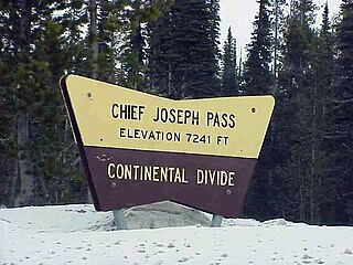
Chief Joseph Pass is a mountain pass on the continental divide of the Rocky Mountains in the northwestern United States joining Lemhi County, Idaho, and Beaverhead County, Montana. The pass is in the Bitterroot Mountains and is traversed by Montana Highway 43; it is named after Chief Joseph of the Wallowa band of the Nez Perce tribe, who traversed the pass in the summer of 1877 during the Nez Perce War, prior to the Battle of the Big Hole to the east.

Lost Trail Pass is a mountain pass in the Rocky Mountains of the northwestern United States, on the border of Idaho and Montana in the Bitterroot Mountains. The pass is at an elevation of 7,014 feet (2,138 m) above sea level and is traversed by U.S. Highway 93.
Nez Perce Pass is a mountain pass in the Bitterroot Mountains on the border between the U.S. states of Idaho and Montana. The pass is at an elevation of 6,587 feet (2,008 m) above sea level. The Nez Perce Pass Trailhead offers access to the Selway-Bitterroot Wilderness and the Frank Church—River of No Return Wilderness.

The Lochsa River is in the northwestern United States, in the mountains of north central Idaho. It is one of two primary tributaries of the Middle Fork of the Clearwater River in the Clearwater National Forest. Lochsa is a Nez Perce word meaning rough water. The Salish name is Ep Smɫí, "It Has Salmon."
Antonio or Anthony Ravalli was an Italian Jesuit missionary, artist, and doctor active in the Pacific Northwest region of the United States. He is known primarily for his contributions to the architecture and art of Jesuit missions in the region. He also inoculated the tribes he served against smallpox, and his efforts shielded the Bitterroot Salish against epidemics that devastated other tribes. In 1893 Ravalli County, Montana was named after him.

The Clearwater River is in the northwestern United States, in north central Idaho. Its length is 74.8 miles (120.4 km), it flows westward from the Bitterroot Mountains along the Idaho-Montana border, and joins the Snake River at Lewiston. In October 1805, the Lewis and Clark Expedition descended the Clearwater River in dugout canoes, putting in at "Canoe Camp," five miles (8 km) downstream from Orofino; they reached the Columbia Bar and the Pacific Ocean about six weeks later.
The Ravalli County Museum in Hamilton, Montana, is operated by the Bitter Root Valley Historical Society (BRVHS) in order to acquire, preserve, and interpret the historical and cultural heritage of the Bitter Root Valley and the inhabitants of Ravalli County, Montana. United States. The Museum is open year-round and features three main focal points: local history, natural history and art.
Fort Fizzle was a temporary military barricade in the western United States, erected by the U.S. Army in July 1877 in Montana Territory. Its purpose was to intercept the Nez Perce in their flight from north central Idaho Territory over Lolo Pass into the Bitterroot Valley of western Montana. The name describes the effectiveness of the fort.
Conner is a census-designated place (CDP) in Ravalli County, Montana, United States. The population was 216 at the 2010 census.
Ross' Hole is a valley located in Ravalli County, in Sula State Forest, along U.S. Route 93 in the vicinity of the hamlet of Sula, Montana.