
Bear Lake County is a county in the U.S. state of Idaho. As of the 2010 United States Census the county had a population of 5,986. The county seat is Paris, and Montpelier is the largest city.

The Ruby Lake National Wildlife Refuge is located in southwestern Elko County and northwestern White Pine County in the northeastern section of the state of Nevada in the western United States. Established in 1938, it encompasses 37,632 acres (152.29 km2) of wetlands in Ruby Valley, just east of the Ruby Mountains and just south of Harrison Pass. It is 16 miles (26 km) long, up to 3 miles (4.8 km) in width, and lies at an elevation of 6,000 feet (1,800 m). Once the bed of a 200-foot (61 m) deep lake, it is now a network of spring-fed marshes and shallow ponds serving as a habitat for hundreds of species of native and migratory birds and mammals.

The Desert National Wildlife Refuge is a protected wildlife refuge, administered by the U.S. Fish and Wildlife Service, located north of Las Vegas, Nevada, in northwestern Clark and southwestern Lincoln counties, with much of its land area lying within the southeastern section of the Nevada Test and Training Range. The Desert NWR, created on May 20, 1936, is the largest wildlife refuge in the lower 48 states of the United States, encompassing 1.615 million acres (6,540 km2) of the Mojave Desert in the southern part of Nevada. This Range is part of the larger Desert National Wildlife Refuge Complex, which includes the Ash Meadows National Wildlife Refuge, the Moapa Valley National Wildlife Refuge, and the Pahranagat National Wildlife Refuge.

Browns Park National Wildlife Refuge is a 13,450-acre (5,440 ha) U.S. National Wildlife Refuge located in northwestern Colorado. It is located in Moffat County in the extreme northwestern corner of the state, in an isolated mountain valley of Browns Park on both sides of the Green River, approximately 25 miles (40 km) below Flaming Gorge Dam. Established in 1965, the refuge is managed by the United States Fish and Wildlife Service office in Maybell, Colorado. The refuge is approximately 53 miles (85 km) northwest of Maybell on State Highway 318. The refuge consists of bottomland and adjacent benchland. The western border of the refuge is the Colorado-Utah state line. The refuge is surrounded by adjacent lines of the Bureau of Land Management. The refuge contains the site of the former Fort Davy Crockett constructed in 1837 to protect trappers against attacks by Blackfoot Native Americans.
Ridgefield National Wildlife Refuge is a wildlife preserve, one of the national wildlife refuges operated by the United States Fish and Wildlife Service, located in the westernmost part of Clark County, Washington. The refuge protects more than 5,200 acres (2,100 ha) of marshes, grasslands, and woodlands. The refuge was established in 1965, in response to a need to establish vital winter habitat for wintering waterfowl with an emphasis on the dusky Canada goose whose nesting areas in Alaska were severely impacted by the violent earthquake of 1964.
The Klamath Basin National Wildlife Refuge Complex is a wildlife preserve operated by the United States Fish and Wildlife Service in the Klamath Basin of southern Oregon and northern California near Klamath Falls, Oregon. It consists of Bear Valley, Klamath Marsh and Upper Klamath National Wildlife Refuge (NWR) in southern Oregon and Lower Klamath, Tule Lake, and Clear Lake NWR in northern California.

Benton Lake National Wildlife Refuge is a 12,459-acre (5,042 ha) National Wildlife Refuge (NWR) in the central part of the U.S. state of Montana. It lies in northern Cascade County, 12 mi (19 km) north of the city of Great Falls, Montana. Benton Lake NWR includes shortgrass prairie and seasonal wetlands, and is nearly surrounded by the Highwood Mountains to the east, Big Belt Mountains to the south, and the Rocky Mountains to the west. Benton Lake NWR is on the western edge of the northern Great Plains and much of the shallow lake is a 6,000-acre (2,400 ha) wetland.
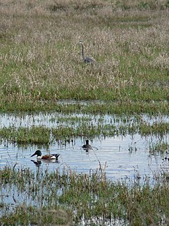
Red Rock Lakes National Wildlife Refuge is a remote refuge located in the high altitude of the Centennial Valley, in the southwestern region of the U.S. state of Montana. Adjacent to Gallatin National Forest and near Yellowstone National Park, the refuge is an integral part of the Greater Yellowstone Ecosystem. Red Rock Lakes is best known for being the primary location for the efforts saving the trumpeter swan from extinction, which by 1932 had fewer than 200 known specimens in the United States and Canada. By the year 2002, an estimated 3,000 trumpeters were wintering on the refuge, many having migrated south from their summer range in Canada. The trumpeters are now so plentiful that efforts are being undertaken to help them reestablish historical migratory routes to areas further south in the Rocky Mountains and the Great Basin region. The elegant trumpeter swan is North America's largest waterfowl, with a wingspans of 8 feet and they can weigh up to 30 pounds (13 kg).
The Okefenokee National Wildlife Refuge is a 402,000‑acre (1,627 km2) National Wildlife Refuge located in Charlton, Ware, and Clinch Counties of Georgia, and Baker County in Florida, United States. The refuge is administered from offices in Folkston, Georgia. The refuge was established in 1937 to protect a majority of the 438,000 acre (1,772 km2) Okefenokee Swamp. The name "Okefenokee" is a Native American word meaning "trembling earth."

The Erie National Wildlife Refuge is an 8,777-acre (3,552 ha) National Wildlife Refuge located in Crawford County, Pennsylvania. Named after the Erie tribe, it was established to provide waterfowl and other migratory birds with nesting, feeding, brooding, and resting habitat.

Baskett Slough National Wildlife Refuge is located in northwestern Oregon, 10 miles (16 km) west of Salem in Polk County. Situated in open farmland near the eastern foothills of the Oregon Coast Range with the broad Willamette Valley and the Cascade Range to the east, elevations range from 185 to 414 feet MSL. The Willamette Valley, with its mild, rainy winter climate, is an ideal environment for wintering waterfowl. The valley was once a rich mix of wildlife habitats with extensive wetlands, meandering stream channels and vast seasonal marshes. Today, the valley is a mix of farmland and growing cities, with few areas remaining for wildlife. The Refuge consists of 1,173 acres (4.75 km²) of cropland, which provide forage for wintering geese, 300 acres (1.2 km²) of forests, 550 acres (2.2 km²) of grasslands, and 500 acres (2.0 km²) of shallow water seasonal wetlands and 35 acres (0.14 km²) of permanent open water. In 1965, Baskett Slough National Wildlife Refuge was created to help ensure some of the original habitat remained for species preservation. The refuge is managed by the U.S. Fish and Wildlife Service, an agency of the U.S. Department of the Interior.
The Minnesota Valley National Wildlife Refuge is a 14,000-acre (5,666 ha) National Wildlife Refuge in eastern and central Minnesota. Located just south of the city of Minneapolis, it is one of fourteen Regional Priority Urban Wildlife Refuges in the nation. Many parts of the Refuge are near large establishments of the Twin Cities; the Bloomington Education and Visitor Center and two trailheads are located just blocks from the Mall of America, the Wilkie Unit is just east of Valleyfair and the Louisville Swamp Unit is just south of Minnesota Renaissance Festival.

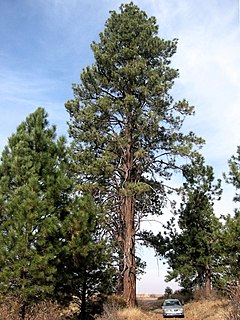
The Eastern Cascades Slopes and Foothills ecoregion is a Level III ecoregion designated by the United States Environmental Protection Agency (EPA) in the U.S. states of Oregon, Washington, and California. In the rain shadow of the Cascade Range, the eastern side of the mountains experiences greater temperature extremes and receives less precipitation than the west side. Open forests of ponderosa pine and some lodgepole pine distinguish this region from the Cascades ecoregion, where hemlock and fir forests are more common, and from the lower, drier ecoregions to the east, where shrubs and grasslands are predominant. The vegetation is adapted to the prevailing dry, continental climate and frequent wildfire. Volcanic cones and buttes are common in much of the region.

The Koyukuk National Wildlife Refuge is a 3,500,000-acre (14,000 km2) conservation area in Alaska. It lies within the floodplain of the Koyukuk River, in a basin that extends from the Yukon River to the Purcell Mountains and the foothills of the Brooks Range. This region of wetlands is home to fish, waterfowl, beaver and Alaskan moose, and wooded lowlands where two species of fox, bears, wolf packs, Canadian lynx and marten prowl.

Tetlin National Wildlife Refuge is a dynamic landscape made up of forests, wetlands, tundra, lakes, mountains and glacial rivers bounded by the snowy peaks of the Alaska Range. This upper Tanana River valley has been called the "Tetlin Passage," because it serves as a major migratory route for birds traveling to and from Canada, the lower 48 and both Central and South America. Many of these birds breed and nest on the refuge. Others pass through on their way to breeding and nesting grounds elsewhere in the state. Migrants, including ducks, geese, swans, cranes, raptors and songbirds, begin arriving in the valley in April, and continue into early June. An estimated 116 species breed on Tetlin during the short summer, when long days and warm temperatures accelerate the growth of plants, insects and other invertebrates, providing a ready source of rich foods for nesting birds.

Grays Lake National Wildlife Refuge is a National Wildlife Refuge of the United States located in southeastern Idaho. It has the largest hardstem bulrush marsh in North America. Located in a high mountain valley near Soda Springs, the refuge and surrounding mountains offer scenic vistas, wildflowers, and fall foliage displays. Lands adjacent to the 19,400-acre (79 km2) refuge are primarily wet meadows and grasslands. The refuge provides breeding habitat for species of mammals including moose, elk, mule deer, muskrat, badger, and weasel.
Hart Lake is a shallow lake in the Warner Valley of eastern Lake County, Oregon, United States. The lake covers 7,324 acres (29.64 km2) and has the most stable water level within the valley's Warner Lakes chain. The lake is named for the heart-shaped brand used by the pioneer Wilson and Alexander cattle ranch established near the lake. Much of the land around Hart Lake is administered by the Bureau of Land Management (BLM) and the United States Fish and Wildlife Service (FWS). The lake and the surrounding wetlands support a wide variety of birds and other wildlife. Recreational opportunities on and near Hart Lake include hunting, fishing, bird watching, and boating.

The Centennial Mountains are the southernmost sub-range of the Bitterroot Range in the United States states of Idaho and Montana. The Centennial Mountains include the Western and Eastern Centennial Mountains. The range extends east from Monida Pass along the Continental Divide to Henrys Fork 48 km (30 mi) NNW of Ashton, Idaho; bounded on the west by Beaver Creek, on the north by Centennial Valley and Henrys Lake Mountains, on the east by Henrys Lake Flat, and on the south by Shotgun Valley and the Snake River Plain. The highest peak in the range is Mount Jefferson.

The P Ranch is a historic ranch in Harney County in southeastern Oregon, United States. The remaining ranch structures are located on the west bank of the Donner und Blitzen River in the Malheur National Wildlife Refuge. The ranch was built by Peter French, a well known 19th-century cattle baron. The P Ranch became headquarters for the French-Glenn Livestock Company, which eventually covered over 140,000 acres (570 km2). After French was murdered in 1897, the French-Glenn Livestock Company slowly sold off the P Ranch property. In 1935, the United States Government purchased the remaining P Ranch property to add to an adjacent wildlife refuge. The Civilian Conservation Corps demolished most of the original ranch buildings in the 1930s, and a fire destroyed the main ranch house in 1947. The few remaining P Ranch structures are now listed on the National Register of Historic Places.

The Sod House Ranch is an historic ranch in Harney County in southeastern Oregon, United States. The remaining ranch structures are located south of Malheur Lake in the Malheur National Wildlife Refuge. The ranch was built by Peter French, a well known 19th-century cattle baron. The Sod House Ranch became the headquarters for the northern operating division of the French-Glenn Livestock Company, which eventually covered over 140,000 acres (570 km2). After French was murdered in 1897, the French-Glenn Livestock Company slowly sold off its ranch property. In 1935, the United States Government purchased the Sod House Ranch property to add to an adjacent wildlife refuge. The eight remaining Sod House Ranch buildings are now listed on the National Register of Historic Places.


