This article needs additional citations for verification .(May 2010) (Learn how and when to remove this template message) |
| Beaverhead-Deerlodge National Forest | |
|---|---|
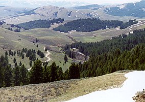
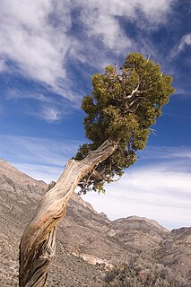
Lemhi Pass in the Beaverhead-Deerlodge National Forest | |
 | |
| Location | Montana, USA |
| Nearest city | Butte, MT |
| Coordinates | 46°08′N112°50′W / 46.133°N 112.833°W Coordinates: 46°08′N112°50′W / 46.133°N 112.833°W |
| Area | 3,357,826 acres (13,588.64 km2) [1] |
| Established | 1905 |
| Governing body | U.S. Forest Service |
| Website | Beaverhead-Deerlodge National Forest |
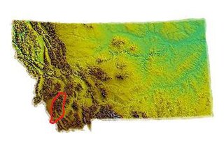
The Beaverhead-Deerlodge National Forest is the largest of the National Forests in Montana, United States. Covering 3.36 million acres (13,600 km2), the forest is broken into nine separate sections and stretches across eight counties in the southwestern area of the state. President Theodore Roosevelt named the two forests in 1908 and they were merged in 1996. Forest headquarters are located in Dillon, Montana. In Roosevelt's original legislation, the Deerlodge National Forest was called the Big Hole Forest Reserve. He created this reserve because the Anaconda Copper Mining Company, based in Butte, Montana, had begun to clearcut the upper Big Hole River watershed. The subsequent erosion, exacerbated by smoke pollution from the Anaconda smelter, was devastating the region. Ranchers and conservationists alike complained to Roosevelt, who made several trips to the area. (Munday 2001)

National Forest is a classification of protected and managed federal lands in the United States. National Forests are largely forest and woodland areas owned collectively by the American people through the federal government, and managed by the United States Forest Service, a division of the United States Department of Agriculture.
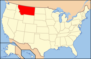
Montana is a landlocked state in the Northwestern United States. Montana has several nicknames, although none are official, including "Big Sky Country" and "The Treasure State", and slogans that include "Land of the Shining Mountains" and more recently "The Last Best Place".

Theodore Roosevelt Jr. was an American statesman, sportsman, conservationist and writer who served as the 26th president of the United States from 1901 to 1909. He previously served as the 25th vice president of the United States from March to September 1901 and as the 33rd governor of New York from 1899 to 1900. As a leader of the Republican Party during this time, he became a driving force for the Progressive Era in the United States in the early 20th century. His face is depicted on Mount Rushmore, alongside those of George Washington, Thomas Jefferson, and Abraham Lincoln. In polls of historians and political scientists, Roosevelt is generally ranked as one of the five best presidents.
Contents
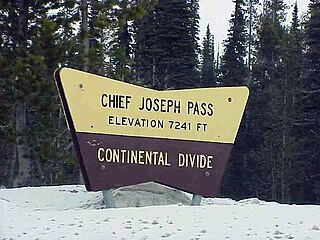
The greatest part of the Anaconda-Pintler Wilderness is located in the larger Beaverhead National Forest portion of 2,130,671 acres (8,622.52 km2), which is 64% of the total area of the forest. The rest of this wilderness extends into the neighboring Deerlodge and Bitterroot National Forests. [2] The Beaverhead section includes most of the Pioneer, Gravelly, and Sapphire Ranges. Both the Centennial and Bitterroot mountain ranges are also located here, with the Continental divide found in the Bitterroot range. Lemhi Pass, at an elevation 7,323 feet (2,300 m) above sea level, is a rounded saddle in the Beaverhead Mountains of the Bitterroot Range, along the Continental Divide, between Montana and Idaho. Here, in 1805, the Lewis and Clark Expedition first saw the headwaters of the Columbia River, which flow to the Pacific Ocean, and crossed what was then the western boundary of the United States. Lemhi Pass was the point at which the members of the expedition realized that there was not a waterway that would lead from east to west across the continent. Lemhi Pass was designated a National Historic Landmark in 1960. The Lee Metcalf Wilderness, in the Madison mountain range, is a part of what is known as the Greater Yellowstone Ecosystem. However, most of the Lee Metcalf lies in neighboring Gallatin National Forest. [3] The Beaverhead section lies, in descending order of land area, in parts of Beaverhead, Madison, Deer Lodge, and Silver Bow counties. There are local ranger district offices located in Dillon, Ennis, Wisdom, and Wise River.

The Anaconda-Pintler Wilderness is located in southwestern Montana, in the northwestern United States. It runs for 40 miles (65 km) along both sides of the crest of the Anaconda Range, covering almost 250 square miles (640 km2). To the north are the Sapphire Mountains, and to the south is the Big Hole Valley. Elevations range from about 5000 feet up to 10,793 feet at West Goat Peak. West Pintler Peak, located in a more commonly visited area, rises to 9894 feet. Visitors can most easily access this area via trailheads at Pintler Lake to the south, and at Lutz Creek and Moose Lake to the north. The wilderness lies in parts of Deer Lodge, Granite, Ravalli, and Beaverhead counties.

Bitterroot National Forest comprises 1.587 million acres (6,423 km²) in west-central Montana and eastern Idaho, of the United States. It is located primarily in Ravalli County, Montana, but also has acreage in Idaho County, Idaho (29.24%), and Missoula County, Montana (0.49%).
The Pioneer Mountains cover 2,000 square miles (5,200 km2) in Beaverhead County in southwestern Montana, USA.
The smaller Deerlodge National Forest portion of 1,227,155 acres (4,966.12 km2), at 37% of the total area of the forest, encompasses much of the Tobacco Root Mountains and Flint Creek Range and parts of the Elkhorn Mountains; it straddles the Continental Divide in the Boulder and Highland Mountains. A number of ghost towns serve as reminders of the extensive mining history of the region. The Deerlodge portion of the forest, located northwest of the Beaverhead portion, lies in sections of Granite, Jefferson, Silver Bow, Deer Lodge, Powell, and Madison counties. There are local ranger district offices located in Butte, Philipsburg, and Whitehall.

The Tobacco Root Mountains lie in the northern Rocky Mountains, between the Jefferson and Madison Rivers in southwest Montana. The highest peak is Hollowtop at 10,604 feet (3,232 m). The range contains 43 peaks rising to elevations greater than 10,000 feet.

The Flint Creek Range, el. 10,168 feet (3,099 m), is a mountain range northeast of Philipsburg, Montana in Granite County, Montana. The highest point in the range is Mount Powell, at 10,168 ft. in elevation.

The Elkhorn Mountains are a mountain range in southwestern Montana, part of the Rocky Mountains and are roughly 300,000 acres (1200 km²) in size. It is an inactive volcanic mountain range with the highest point being Crow Peak at 9,414 ft (2,869 m), right next to Elkhorn Peak, 9,381 ft (2,859 m). The range is surrounded by the cities of Helena, Montana City, Townsend, Whitehall, and Boulder and is part of the Helena National Forest in Montana's Jefferson County.
Ponderosa pine, and various species of fir, spruce and juniper are the dominant tree species. Almost a third of the forest lands have no forest at all, and are instead rangeland with sagebrush, grass and the occasional cactus. The forest is also home to the grizzly bear, Canadian lynx, bald eagle, bull trout, Arctic grayling, and the wolf, the latter being a migrant from northern Montana and from the Yellowstone wolf reintroduction program. Elk, mule deer, moose, bighorn sheep and pronghorn and black bear are more commonly found.

Firs (Abies) are a genus of 48–56 species of evergreen coniferous trees in the family Pinaceae. They are found through much of North and Central America, Europe, Asia, and North Africa, occurring in mountains over most of the range. Firs are most closely related to the genus Cedrus (cedar). Douglas firs are not true firs, being of the genus Pseudotsuga.

A spruce is a tree of the genus Picea, a genus of about 35 species of coniferous evergreen trees in the family Pinaceae, found in the northern temperate and boreal (taiga) regions of the Earth. Spruces are large trees, from about 20–60 m tall when mature, and have whorled branches and conical form. They can be distinguished from other members of the pine family by their needles (leaves), which are four-sided and attached singly to small persistent peg-like structures (pulvini) on the branches, and by their cones, which hang downwards after they are pollinated. The needles are shed when 4–10 years old, leaving the branches rough with the retained pegs. In other similar genera, the branches are fairly smooth.
Junipers are coniferous plants in the genus Juniperus of the cypress family Cupressaceae. Depending on taxonomic viewpoint, between 50 and 67 species of junipers are widely distributed throughout the Northern Hemisphere, from the Arctic, south to tropical Africa, from Ziarat, Pakistan, east to eastern Tibet in the Old World, and in the mountains of Central America. The highest-known juniper forest occurs at an altitude of 16,000 ft (4,900 m) in southeastern Tibet and the northern Himalayas, creating one of the highest tree-lines on earth.
The highest mountains in the forest top out at over 11,000 feet (3,400 m). The Continental Divide National Scenic Trail and the Nez Perce National Historical Trail both pass through sections of the forest. In total, there are over 1,500 miles (2,400 km) of hiking trails, 50 campgrounds, dozens of lake and river boating access points and even 250 miles (400 km) of groomed snowmobile trails.

Hiking is the preferred term, in Canada and the United States, for a long, vigorous walk, usually on trails (footpaths), in the countryside, while the word walking is used for shorter, particularly urban walks. On the other hand, in the United Kingdom, and the Republic of Ireland, the word "walking" is acceptable to describe all forms of walking, whether it is a walk in the park or backpacking in the Alps. The word hiking is also often used in the UK, along with rambling, hillwalking, and fell walking. The term bushwalking is endemic to Australia, having been adopted by the Sydney Bush Walkers club in 1927. In New Zealand a long, vigorous walk or hike is called tramping. It is a popular activity with numerous hiking organizations worldwide, and studies suggest that all forms of walking have health benefits.

A trail is usually a path, track or unpaved lane or road. In the United Kingdom and the Republic of Ireland path or footpath is the preferred term for a walking trail. The term is also applied, in North America, to routes along rivers, and sometimes to highways. In the US, the term was historically used for a route into or through wild territory used by emigrants. In the USA "trace" is a synonym for trail, as in Natchez Trace. Some trails are single use and can only be used for walking, cycling, horse riding, snowshoeing, and cross-country skiing; others, as in the case of a bridleway in the UK, are multi-use, and can be used by walkers, cyclists and equestrians. There are also unpaved trails used by dirt bikes and other off-road vehicles and in some places, like the Alps, trails are used for moving cattle and other livestock.

A lake is an area filled with water, localized in a basin, that is surrounded by land, apart from any river or other outlet that serves to feed or drain the lake. Lakes lie on land and are not part of the ocean, and therefore are distinct from lagoons, and are also larger and deeper than ponds, though there are no official or scientific definitions. Lakes can be contrasted with rivers or streams, which are usually flowing. Most lakes are fed and drained by rivers and streams.
Forest Service offices administering the National Forest are in Butte, Dillon (which is the headquarters location), Philipsburg, Deer Lodge, Whitehall, Boulder, Ennis, Sheridan, Wise River, Wisdom, and Lima. Interstate 15 and Interstate 90, Montana Highway 43 and Montana Highway 278, and the Pioneer Mountains Scenic Byway all provide access to forest service roads, trailheads and local communities near the forest.

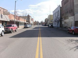
Butte is the county seat of Silver Bow County, Montana, United States. In 1977, the city and county governments consolidated to form the sole entity of Butte-Silver Bow. The city covers 718 square miles (1,860 km2), and, according to the 2010 census, has a population of approximately 36,400, making it Montana's fifth largest city. It is served by Bert Mooney Airport with airport code BTM.
Dillon is a city in and the county seat of Beaverhead County, Montana, United States. The population was 4,134 at the 2010 census. The city was named for Union Pacific Railroad President Sidney Dillon.

Philipsburg is a town in and the county seat of Granite County, Montana, United States. The population was 820 at the 2010 census. The town was named after the famous mining engineer Philip Deidesheimer, who designed and supervised the construction of the ore smelter around which the town originally formed.