
The Flathead Indian Reservation, located in western Montana on the Flathead River, is home to the Bitterroot Salish, Kootenai, and Pend d'Oreilles tribes - also known as the Confederated Salish and Kootenai Tribes of the Flathead Nation. The reservation was created through the July 16, 1855, Treaty of Hellgate.

Wild Horse Island is the largest island on Flathead Lake, the largest freshwater lake in Montana. For centuries, the Salish-Kootenai used the island, approximately 2,164 acres (876 ha) in size, in order to pasture horses and keep them from being stolen by other tribes. The island was part of the Flathead Indian Reservation from the time of its creation in 1872 up until its dismantlement in 1904, when the island was divided into individual plots of land. A number of attempts were made on the island towards agricultural development, but none succeeded.

Dunn State Park is a public recreation area surrounding a 20-acre (8.1 ha) pond in Gardner, Massachusetts. The state park covers 132 acres (53 ha) and is managed by the Department of Conservation and Recreation.
Lake Wissota State Park is a 1,062-acre (430 ha) Wisconsin state park near the town of Chippewa Falls. The park is situated on the northeast shore of Lake Wissota, a reservoir on the Chippewa River. Camping, boating, and fishing are the most popular activities. Park lands are covered in a mix of pine/hardwood forests and prairie. Visitors can access the Old Abe State Trail and bike or hike 17.5 miles (28.2 km) to Brunet Island State Park.

Red Hills State Park is an Illinois state park on 967 acres (391 ha) in Lawrence County, Illinois, United States. The park sits at an elevation of 515 feet (157 m). Red Hills State Park is open for year-round recreation including boating, fishing, hunting, hiking and various winter sports. The park includes a restaurant which is open year-round and has banquet facilities.
Nolte State Park is a 117-acre (47 ha) Washington state park located 6 miles (9.7 km) northeast of Enumclaw and just south of Cumberland at the western edge of the Cascade Mountains, with 7,174 feet (2,187 m) of shoreline on Deep Lake near the Green River Gorge. The property was a resort for many years before it was donated to the state by Minnie Nolte in the early 1970s. There are rainbow trout, coastal cutthroat trout, kokanee, crappie, and brown bullhead in the lake. The lake has a public fishing pier, beach area, and a hiking trail around the lake. The boat launch is carry-in only with limited parking. Deep Lake has a surface area of 39 acres (16 ha) and reaches a depth of 76 feet (23 m).

Silver Springs State Fish and Wildlife Area is an Illinois state park on 1,350 acres (550 ha) in Kendall County, Illinois, United States. The park was established in the late 1960s and is named for the natural spring within its boundaries. The park has two artificial lakes and the Fox River flows through the northern end of the park. Silver Springs hosts a variety of activities including fishing, hunting, boating and hiking. The park has areas of native prairie restoration, a sledding hill and a seven-mile (11 km) equestrian trail. The prairie restoration areas hold many species of plants including lead plant, and purple coneflower.

Thompson Falls State Park is a public recreation area occupying 36 acres (15 ha) on the banks of the Clark Fork River, one mile northwest of Thompson Falls, Montana. The state park features a boat launch, children's fishing pond, and riverside trail with mature pine forests surrounding 17 campsites, a group use area, and picnicking facilities. Activities include boating, fishing, picnicking, birdwatching, and nature walks. The park is fully open from spring to fall and available for walk-in day use during the rest of the year.
Lost Creek State Park is a public recreation area located six miles north of Anaconda, Montana, featuring limestone cliffs and multi-colored rock formations that rise 1,200 feet (370 m) above its canyon floor.The 502 acres (203 ha) state park features a short walking trail to Lost Creek Falls, which plunge 50 feet (15 m). The park is open seasonally and offers camping, fishing, picnicking, bicycling, hiking and wildlife viewing with mountain goats and bighorn sheep commonly seen.

Lake Elmo State Park is a public recreation area located on the northeast side of Billings, Montana. The state park occupies 123 acres (50 ha) and is at an elevation of 3,199 feet (975 m). It offers non-motorized boating on a 64-acre (26 ha) reservoir, three beach-front areas, fishing pier, grassed multi-use areas, two group-use shelters, playground, and fenced-in dog park on the lake's west side.

Black Sandy State Park, located 15 miles (24 km) north of Helena, Montana, in Lewis and Clark County, is a Montana state park on the shores of Hauser Lake, which is formed by Hauser Dam.

Ackley Lake State Park is a public recreation area located four miles southwest of Hobson, Montana. The state park covers 290 acres (120 ha) centered around 160-acre (65 ha) Ackley Lake. The Little Belt Mountains and Snowy Mountains are visible on the horizon. The park is operated by the Montana Department of Fish, Wildlife and Parks on land leased from the Montana Department of Natural Resources and Conservation.

Brush Lake State Park is a public recreation area located four miles east of the community of Dagmar, Montana. The park surrounds three sides of the highly alkaline, 280-acre (110 ha), sixty-foot-deep Brush Lake.
Clark's Lookout State Park is a Montana state park located one mile north of the community of Dillon. The 8-acre (3.2 ha) park encompasses the hill overlooking the Beaverhead River that William Clark climbed on August 13, 1805, during the Lewis and Clark Expedition. From the vantage point, Clark took various compass readings and sketched a map of the Beaverhead Valley. The park offers picnicking, interpretive signage, and a chance to make the climb that Clark made and stand where he stood.
Council Grove State Park is a history-oriented, public recreation area located eight miles (13 km) northwest of Missoula in Missoula County, Montana. The site of the park hosted the signing on July 16, 1855, of the Hellgate treaty between representatives of the United States government and members of the Bitterroot Salish, Pend d'Oreille, and the Kootenai to create the Flathead Indian Reservation. A monument commemorates the signing. The park is 187 acres (76 ha) and sits at an elevation of 3,198 feet (975 m). Natural features found in the park are its large, old-growth ponderosa pines, grassy fields, and cottonwood stand by the Clark Fork River. Its recreational features include hiking and fishing.
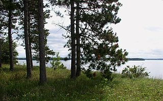
West Shore State Park is a public recreation area occupying 129 acres on the western shore of Flathead Lake five miles south of Lakeside in Lake County, Montana. The state park offers boating, fishing, camping, swimming, hiking, and wildlife viewing.
Frenchtown Pond State Park is a public recreation area located ten miles (16 km) northwest of Missoula in Frenchtown, Montana. The 41-acre (17 ha) day-use state park offers fishing, swimming, and non-motorized boating on a small, spring-fed lake with a maximum eighteen-foot (5.5 m) depth.

Hell Creek State Park is a public recreation area on the south side of Fort Peck Lake located twenty miles (32 km) due north of the community of Jordan, Montana. The state park's 337 acres (136 ha) sit on the western side of Hell Creek Bay and include a year-round marina, facilities for most water sports, camping, and fishing for walleye, northern pike, smallmouth bass, and spring lake trout.
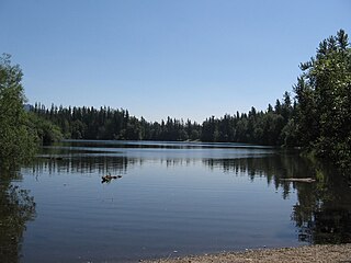
Logan State Park is a public recreation area on the north shore of Middle Thompson Lake, off US Route 2 midway between Libby and Kalispell, Montana. The state park encompasses 17 acres (6.9 ha) within 3,000-acre Thompson Chain of Lakes State Park. It offers swimming, boating, fishing, and camping.
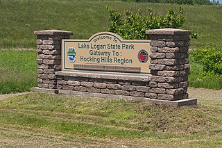
Lake Logan State Park is an Ohio state park in Hocking County, Ohio, United States. Lake Logan State Park is located in Falls Township, Hocking County, Ohio. Lake Logan Dam is directly accessible off State Route 664 just southwest of the county seat of Logan. Lake Logan State Park lies in the Hocking Valley, formed by the Hocking River. Lake Logan was created in 1955 with the construction of the Lake Logan Dam on Clear Fork Creek, a tributary of the Hocking River. Lake Logan is a 400-acre (160 ha) lake and is open to fishing, boating, ice fishing, ice boating and swimming.


