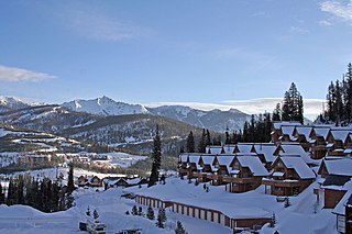
Big Sky is an unincorporated community and census-designated place (CDP) in Gallatin and Madison counties in southwestern Montana, United States. As of the 2020 census, it had a population of 3,591, up from 2,308 in 2010. It is 44 miles (71 km) by road southwest of Bozeman. The primary industry of the area is tourism.

The Madison River is a headwater tributary of the Missouri River, approximately 183 miles (295 km) long, in Wyoming and Montana. Its confluence with the Jefferson and Gallatin rivers near Three Forks, Montana forms the Missouri River.

The Gallatin River is a tributary of the Missouri River, approximately 120 mi (193 km) long, in the U.S. states of Wyoming and Montana. It is one of three rivers, along with the Jefferson and Madison, that converge near Three Forks, Montana, to form the Missouri.

The Bob Marshall Wilderness Area is a congressionally-designated wilderness area located in Western Montana region of the United States. It is named after Bob Marshall (1901–1939), an early forester in the federal government, conservationist, and co-founder of The Wilderness Society. In the 1930s while working for the Forest Service, Marshall was largely responsible for designation of large areas to be preserved as roadless within lands administered by the Forest Service; he achieved this through promulgation of various regulations. Formally designated in 1964, the Bob Marshall Wilderness extends for 60 miles (97 km) along the Continental Divide and consists of 1,009,356 acres (4,084.72 km2).

The Beartooth Mountains are located in south central Montana and northwest Wyoming, U.S. and are part of the 944,000 acres (382,000 ha) Absaroka-Beartooth Wilderness, within Custer, Gallatin and Shoshone National Forests. The Beartooths are the location of Granite Peak, which at 12,807 feet (3,904 m) is the highest point in the state of Montana. The mountains are just northeast of Yellowstone National Park and are part of the Greater Yellowstone Ecosystem. The mountains are traversed by road via the Beartooth Highway with the highest elevation at Beartooth Pass 10,947 ft (3,337 m)). The name of the mountain range has been attributed by the U.S. Forest Service to a rugged peak found in the range, Beartooth Peak, that has the appearance of a bear's tooth. Originally, the Beartooth Mountains were named after Beartooth Butte, a large block of paleozoic sediments on the Beartooth Plateau, and Beartooth Butte was named for a tooth-like structure that projects from the front of the butte.

The Gallatin National Forest is a United States National Forest located in South-West Montana. Most of the Custer-Gallatin goes along the state's southern border, with some of it a part of North-West Wyoming.

Absaroka–Beartooth Wilderness was created from existing National Forest lands in 1978 and is located in Montana and Wyoming, United States. The wilderness encompasses two distinct mountain ranges: the Beartooth and Absaroka ranges. These ranges are completely distinct geologically speaking, with the Absaroka composed primarily of volcanic and metamorphic rock, while the Beartooth is made up almost entirely of granitic rocks. The Absaroka are noted for their dark and craggy appearance, lush and heavily forested valleys, and abundant wildlife. The highest peak in the range, in Wyoming, is Francs Peak at 13,153 feet (4,009 m). The Beartooth is more alpine, with huge treeless plateaus and the highest peak of Montana. The wilderness has more than 120 peaks over 10,000 feet (3,000 m) and 28 peaks over 12,000 feet (3,700 m), including Montana's highest, Granite Peak at 12,799 feet (3,901 m). The wilderness is integral to the 20-million-acre (81,000 km2) Greater Yellowstone Ecosystem and borders Yellowstone National Park.

Custer National Forest is located primarily in the south central part of the U.S. state of Montana but also has separate sections in northwestern South Dakota. With a total area of 1,188,130 acres (4,808 km2), the forest comprises over 10 separate sections. While in the westernmost sections, Custer National Forest is a part of the Greater Yellowstone Ecosystem, the easternmost sections are a combination of forest "islands" and grasslands. A portion of the forest is also part of the Absaroka-Beartooth Wilderness and constitutes over a third of the wilderness land. South of Red Lodge, Montana, the Beartooth Highway passes through the forest en route to Yellowstone National Park.

The Beaverhead–Deerlodge National Forest is the largest of the National Forests in Montana, United States. Covering 3.36 million acres (13,600 km2), the forest is broken into nine separate sections and stretches across eight counties in the southwestern area of the state. President Theodore Roosevelt named the two forests in 1908 and they were merged in 1996. Forest headquarters are located in Dillon, Montana. In Roosevelt's original legislation, the Deerlodge National Forest was called the Big Hole Forest Reserve. He created this reserve because the Anaconda Copper Mining Company, based in Butte, Montana, had begun to clearcut the upper Big Hole River watershed. The subsequent erosion, exacerbated by smoke pollution from the Anaconda smelter, was devastating the region. Ranchers and conservationists alike complained to Roosevelt, who made several trips to the area. (Munday 2001)

Bitterroot National Forest comprises 1.587 million acres (6,423 km2) in west-central Montana and eastern Idaho of the United States. It is located primarily in Ravalli County, Montana, but also has acreage in Idaho County, Idaho (29.24%), and Missoula County, Montana (0.49%).

Popo Agie Wilderness is located within Shoshone National Forest, Wyoming, United States. The wilderness consists of 101,870 acres on the east side of the continental divide in the Wind River Range. Originally set aside as a primitive area in 1932, in 1984 the Wyoming Wilderness Act was passed securing a more permanent protection status for the wilderness. The wilderness is a part of the 20,000,000 acres Greater Yellowstone Ecosystem.

The Bridger Wilderness is located in Bridger-Teton National Forest in Wyoming, United States. Originally established in 1931 as a primitive area, 428,169-acre (1,732.74 km2) region was redesignated as a wilderness in 1964 and expanded to the current size in 1984. The wilderness lies on the west side of the Continental Divide in the Wind River Range and contains Gannett Peak; at 13,809 feet (4,209 m) it is the tallest mountain in Wyoming. The wilderness is a part of the Greater Yellowstone Ecosystem.
Teton Wilderness is located in Wyoming, United States. Created in 1964, the Teton Wilderness is located within Bridger-Teton National Forest and consists of 585,238 acres (2,370 km2). The wilderness is bordered on the north by Yellowstone National Park and to the west by Grand Teton National Park and the John D. Rockefeller Jr. Memorial Parkway. The Washakie Wilderness is to the east and the remainder of Bridger-Teton National Forest is to the south. The Teton Wilderness is a part of the 20 million-acre (81,000 km2) Greater Yellowstone Ecosystem. Among many other features, Teton Wilderness is notable for having the most remote location of any place in the contiguous 48 states of the US. This location occurs very close to Bridger Lake, near the confluence of the Thorofare and Yellowstone Rivers, not far from the USFS Hawk's Rest Ranger Station.

The Great Bear Wilderness is located in northern Montana, United States, within Flathead National Forest Created by an act of Congress in 1978, the wilderness comprises 286,700 acres (1,160 km2) and borders the Bob Marshall Wilderness on the north. The Great Bear and Bob Marshall Wildernesses, along with the Scapegoat Wilderness which borders the Bob Marshall to the south, collectively form the Bob Marshall Wilderness Complex, which is over 1.5 million acres (6,100 km2) of almost untouched landscape. Glacier National Park is separated from the Great Bear Wilderness by U.S. Highway 2.
The Winegar Hole Wilderness is located in the U.S. state of Wyoming. Designated wilderness by Congress in 1984, the wilderness is within Caribou-Targhee National Forest and borders Yellowstone National Park. The wilderness was created to further protect what is considered to be prime grizzly bear habitat. The wilderness is an integral part of the Greater Yellowstone Ecosystem.

The Gallatin Range is a mountain range of the Rocky Mountains, located in the U.S. states of Montana and Wyoming. It includes more than 10 mountains over 10,000 feet (3,000 m). The highest peak in the range is Electric Peak at 10,969 feet (3,343 m).

Eagle Peak is a mountain in the Absaroka Range in the U.S. state of Wyoming and at 11,372 feet (3,466 m) is the highest point in Yellowstone National Park. It is located about 6 miles (9.7 km) east of the southeast arm of Yellowstone Lake.
The Madison Range is a mountain range located in the Rocky Mountains of Montana and Idaho in the United States. The range was named in honor of future President of the United States, then U.S. Secretary of State James Madison by Meriwether Lewis as the Lewis and Clark Expedition travelled through Montana in 1805. The range extends 80 miles (130 km) from West Yellowstone, Montana to Bozeman, Montana and is flanked by the Madison River on the west and the Gallatin River to the east. The highest point in the range is Hilgard Peak at 11,316 ft (3,449 m), a remote peak that wasn't climbed until 1948.

The ecology of the Rocky Mountains is diverse due to the effects of a variety of environmental factors. The Rocky Mountains are the major mountain range in western North America, running from the far north of British Columbia in Canada to New Mexico in the southwestern United States, climbing from the Great Plains at or below 1,800 feet (550 m) to peaks of over 14,000 feet (4,300 m). Temperature and rainfall varies greatly also and thus the Rockies are home to a mixture of habitats including the alpine, subalpine and boreal habitats of the Northern Rocky Mountains in British Columbia and Alberta, the coniferous forests of Montana and Idaho, the wetlands and prairie where the Rockies meet the plains, a different mix of conifers on the Yellowstone Plateau in Wyoming, the montane forests of Utah, and in the high Rockies of Colorado and New Mexico, and finally the alpine tundra of the highest elevations.


