War Horse National Wildlife Refuge

Last updated
War Horse National Wildlife Refuge
IUCN category IV (habitat/species management area)
War Horse Lake.jpg
War Horse Lake
Usa edcp relief location map.png
Red pog.svg
Location Petroleum County, Montana, United States
Nearest city Winnett, MT
Coordinates 46°53′34″N108°29′18″W / 46.89278°N 108.48833°W / 46.89278; -108.48833 [1] Coordinates: 46°53′34″N108°29′18″W / 46.89278°N 108.48833°W / 46.89278; -108.48833 [1]
Area3,392 acres (1,373 ha)
Established1958
Governing body U.S. Fish and Wildlife Service
Website War Horse National Wildlife Refuge

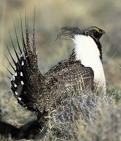
War Horse National Wildlife Refuge, located in the center of the U.S. state of Montana, is divided into three separate sections, with each centered on a small body of water. [2] [3] It is an integral part of the Charles M. Russell National Wildlife Refuge Complex, although the refuge is normally unstaffed and has few visitor improvements. One reservoir is stocked with rainbow trout, although the lake is sometimes empty. When the lakes and reservoir are fully filled, the refuge provides excellent habitat for migratory bird species. The region is surrounded by sagebrush plains and Ponderosa pine groves that flourish in the region solely due to its acid-shale soils. Along with over 100 bird species, regular inhabitants include Sage Grouse, pronghorn and mule deer. [4]

Sage Grouse SageGrouse21.jpg
Sage Grouse

Related Research Articles

Neches River

The Neches River begins in Van Zandt County west of Rhine Lake and flows for 416 miles (669 km) through the piney woods of east Texas, defining the boundaries of 14 counties on its way to its mouth on Sabine Lake near the Rainbow Bridge. Two major reservoirs, Lake Palestine and B. A. Steinhagen Reservoir are located on the Neches. The Angelina River is a major tributary with its confluence at the north of Lake B. A. Steinhagen. Tributaries to the south include Village Creek and Pine Island Bayou, draining much of the Big Thicket region, both joining the Neches a few miles north of Beaumont. Towns and cities located along the river including Tyler, Lufkin, and Silsbee, although significant portions of the Neches River are undeveloped and flow through protected natural lands. In contrast, the lower 40 miles of the river are a major shipping channel, highly industrialized, with a number of cities and towns concentrated in the area including Beaumont, Vidor, Port Neches, Nederland, Groves, and Port Arthur.

Salt Plains National Wildlife Refuge

The Salt Plains National Wildlife Refuge is part of the United States system of national wildlife refuges. It is located in Alfalfa County in northern Oklahoma, north of Jet, along Great Salt Plains Lake, which is formed by a dam on the Salt Fork of the Arkansas River.

Wichita Mountains Wildlife Refuge

Wichita Mountains Wildlife Refuge, located in southwestern Oklahoma near Lawton, has protected unique wildlife habitats since 1901 and is the oldest managed wildlife facility in the United States Fish and Wildlife Service system. Measuring about 59,020 acres (238.8 km2), the refuge hosts a great diversity of species: 806 plant species, 240 species of birds, 36 fish, and 64 reptiles and amphibians are present. The refuge's location in the geologically unique Wichita Mountains and its areas of undisturbed mixed grass prairie make it an important conservation area. The Wichitas are approximately 500 million years old.

Charles M. Russell National Wildlife Refuge Protected area surrounding Fort Peck Reservoir on the Missouri River

The Charles M. Russell National Wildlife Refuge is a National Wildlife Refuge in the U.S. state of Montana on the Missouri River. The refuge surrounds Fort Peck Reservoir and is 915,814 acres (3,706.17 km2) in size. It is the second-largest National Wildlife Refuge in the lower 48 states of the United States, and the largest in Montana. Created in 1936, it was originally called the Fort Peck Game Range. It was renamed in 1963 after Montana artist Charles M. Russell, a famous painter of the American West. In 1976, the "range" was made a "refuge".

Bowdoin National Wildlife Refuge

Bowdoin National Wildlife Refuge is a 15,551-acre (6,293 ha) National Wildlife Refuge (NWR) located in the north-central region of the U.S. state of Montana. The refuge is 7 mi (11 km) northeast of Malta, Montana in the Milk River Valley and is managed by the U.S. Fish and Wildlife Service.

Lost Trail National Wildlife Refuge

Lost Trail National Wildlife Refuge is a 8,834-acre (3,575 ha) National Wildlife Refuge of the United States located in Montana. Established in 1999, it is one of the newest National Wildlife Refuges in the U.S. and is managed by the U.S. Fish and Wildlife Service, an agency of the U.S. Department of the Interior. The refuge was originally a sprawling horse and cattle ranch dating back to the late 19th century and was known as the Lost Trail Ranch. The refuge consists of prairie and wetlands, and has a wide diversity of plant and animal species, including over 100 species of birds such as canada geese, sandhill crane, wood duck, green-winged teals and herons. Several species of grouse also inhabit the refuge. Predatory bird species such as the great horned owl and red-tailed hawk are also found here.

Ninepipe National Wildlife Refuge

Ninepipe National Wildlife Refuge is a 4,027-acre (1,630 ha) National Wildlife Refuge and unit of the National Bison Range Complex, located in Lake County, Montana.

Pablo National Wildlife Refuge

Pablo National Wildlife Refuge is a National Wildlife Refuge of the United States located in northwestern Montana. It is a unit of the National Bison Range Complex of refuges. It is within the Flathead Indian Reservation, about 2 mi (3.2 km) south of Polson.

Medicine Lake National Wildlife Refuge

Medicine Lake National Wildlife Refuge is a 31,533-acre (12,761 ha) National Wildlife Refuge located in the northeastern region of the U.S. state of Montana. The refuge is part of the Medicine Lake National Wildlife Refuge Complex which also includes the Northeast Montana Wetland Management District (WMD) and Lamesteer National Wildlife Refuge. Medicine Lake is from the Assiniboine description of the lake, "Bda wauka". The refuge was established in 1935 to protect habitat for various wildlife and especially migratory birds. The refuge is managed by the U.S. Fish and Wildlife Service, an agency of the U.S. Department of the Interior. In 1980, the Medicine Lake Site was designated as a National Natural Landmark by the National Park Service.

Lamesteer National Wildlife Refuge

Lamesteer National Wildlife Refuge is an 800-acre (320 ha) National Wildlife Refuge in eastern Montana, U.S. All of the acreage is an easement refuge and is on privately owned land but the landowners and U.S. Government work cooperatively to protect the resources. The refuge was set aside to preserve habitat for migratory birds that frequent Lamesteer Reservoir, and the refuge and reservoir are named after Lame Steer Creek. The refuge is unstaffed and is managed from Medicine Lake National Wildlife Refuge.

North Platte National Wildlife Refuge

North Platte National Wildlife Refuge is located in the U.S. state of Nebraska and includes 5,047 acres (20.42 km2). Managed by the U.S. Fish and Wildlife Service, the refuge is broken into four separate sections that are superimposed on U.S. Bureau of Reclamation–managed lakes and reservoirs. Together with the Crescent Lake National Wildlife Refuge, the two refuges form the Crescent Lake National Wildlife Refuge Complex.

Sam D. Hamilton Noxubee National Wildlife Refuge

Sam D. Hamilton Noxubee National Wildlife Refuge is a 48,000 acres (190 km2) National Wildlife Refuge located in the U.S. state of Mississippi, in Noxubee, Oktibbeha, and Winston Counties. The refuge serves as a resting and feeding area for migratory birds and as example of proper land stewardship. Also, the refuge extensively manages land for the endangered red-cockaded woodpecker.

Arrowwood National Wildlife Refuge

Arrowwood National Wildlife Refuge is located in the U.S. state of North Dakota. Arrowwood NWR is a part of the Arrowwood National Wildlife Refuge Complex, and is managed by the U.S. Fish and Wildlife Service. The refuge parallels 16 miles (27 km) of the James River and is a mixture of wetlands, forest and prairie. Efforts to ensure the refuge continues to provide prime nesting habitat for waterfowl include prescribed fire, haying, crop cultivation and livestock grazing. The refuge has forests with oak and hackberry which are uncommon on the prairie. It is believed that the name for the refuge is derived from Native American naming for arrow wood, as the wood in the forest was prized for the making of arrows.

Deer Flat National Wildlife Refuge

The Deer Flat National Wildlife Refuge is an important breeding area for mammals, birds, and other animals. The National Wildlife Refuge is located on land surrounding Lake Lowell, just outside Nampa, Idaho. It serves as a resting and wintering area for birds, including mallards and Canada geese, along the Pacific Flyway and was named a "Globally Important Bird Area" by the American Bird Conservancy.

Tualatin River National Wildlife Refuge

The Tualatin River National Wildlife Refuge is a 1,856 acres (751 ha) wetlands and lowlands sanctuary in the northwestern part of the U.S. state of Oregon. Established in 1992 and opened to the public in 2006, it is managed by the United States Fish and Wildlife Service. Located in southeastern Washington County, 15 miles (24 km) southwest of Portland, the refuge is bordered by Sherwood, Tualatin and Tigard. A newer area, extending into northern Yamhill County, is located further west near the city of Gaston surrounding the former Wapato Lake.

Audubon National Wildlife Refuge

Audubon National Wildlife Refuge is a 14,739-acre (5,965 ha) National Wildlife Refuge in the U.S. state of North Dakota. The refuge is managed by the U.S. Fish and Wildlife Service and is the centerpiece of the Audubon National Wildlife Refuge Complex, which includes numerous other refuges in the region. Originally designated as the Snake Creek National Wildlife Refuge in 1955, the refuge was renamed in 1967 in honor of the artist and naturalist John James Audubon. Most of the refuge area is a lake known as Audubon Lake which is managed by the U.S. Army Corps of Engineers.

Lake Ilo National Wildlife Refuge

Lake Ilo National Wildlife Refuge (NWR) is located in the U.S. state of North Dakota and is managed from Audubon National Wildlife Refuge by the U.S. Fish and Wildlife Service. The refuge consists of Lake Ilo, surrounding wetlands and some upland range, providing habitat for hundreds of species of birds, and numerous fish and mammal species. An average of over 16 inches (40 cm) of precipitation falls annually, supporting a prairie ecosystem.

Bill Williams River

The Bill Williams River is a 46.3-mile-long (74.5 km) river in west-central Arizona where it, along with its tributary, the Santa Maria River, form the boundary between Mohave County to the north and La Paz County to the south. It is a major drainage westwards into the Colorado River of the Lower Colorado River Valley south of Hoover Dam and Lake Mead, and the drainage basin covers portions of northwest, and west-central Arizona. The equivalent drainage system paralleling the east–west lower reaches of the Bill Williams is the Gila River, which flows east-to-west across central Arizona, joining the Colorado River in the southwest at Yuma. The confluence of the Bill Williams River with the Colorado is north of Parker, and south of Lake Havasu City.

Bill Williams River National Wildlife Refuge

The Bill Williams River National Wildlife Refuge protects the lower course of the Bill Williams River, to its mouth at Lake Havasu reservoir, in western Arizona. It is located within eastern La Paz and Mohave Counties, in the Lower Colorado River Valley region.

Assabet River National Wildlife Refuge protected wildlife area and former military installation in central Massachusetts, United States

The Assabet River National Wildlife Refuge is a 2,230-acre (9.0 km2) protected National Wildlife Refuge located approximately 25 miles (40 km) west of Boston and 4 miles (6.4 km) west of the Eastern Massachusetts National Wildlife Refuge Complex Headquarters, along the Assabet River. It is located in portions of the towns of Hudson, Maynard, Stow and Sudbury. The Assabet River National Wildlife Refuge consists of two separate pieces of land. The larger northern section is just north of Hudson Road, extending north to the Assabet River. The southern section is located to the south of Hudson Road. There is a visitor center located in the northern section on Winterberry Way.

References

  1. 1 2 "War Horse National Wildlife Refuge". Geographic Names Information System . United States Geological Survey . Retrieved March 9, 2014.
  2. Teigen, MT (Map). Topoquest (USGS Quads). Retrieved March 9, 2014.
  3. "Annual Report of Lands Under Control of the U.S. Fish and Wildlife Service" (pdf). U.S. Fish and Wildlife Service. September 30, 2010. p. 23. Retrieved March 9, 2014.
  4. "War Horse National Wildlife Refuge". U.S. Fish and Wildlife Service. Retrieved March 9, 2014.