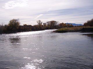
The Jefferson River is a tributary of the Missouri River, approximately 83 miles (134 km) long, in the U.S. state of Montana. The Jefferson River and the Madison River form the official beginning of the Missouri at Missouri Headwaters State Park near Three Forks. It is joined 0.6 miles (1.0 km) downstream (northeast) by the Gallatin.

The Gallatin River is a tributary of the Missouri River, approximately 120 mi (193 km) long, in the U.S. states of Wyoming and Montana. It is one of three rivers, along with the Jefferson and Madison, that converge near Three Forks, Montana, to form the Missouri.
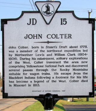
John Colter was a member of the Lewis and Clark Expedition (1804–1806). Though party to one of the more famous expeditions in history, Colter is best remembered for explorations he made during the winter of 1807–1808, when he became the first known person of European descent to enter the region which later became Yellowstone National Park and to see the Teton Mountain Range. Colter spent months alone in the wilderness and is widely considered to be the first known mountain man.

The Bob Marshall Wilderness Area is a congressionally-designated wilderness area located in Western Montana region of the United States. It is named after Bob Marshall (1901–1939), an early forester in the federal government, conservationist, and co-founder of The Wilderness Society. In the 1930s while working for the Forest Service, Marshall was largely responsible for designation of large areas to be preserved as roadless within lands administered by the Forest Service; he achieved this through promulgation of various regulations. Formally designated in 1964, the Bob Marshall Wilderness extends for 60 miles (97 km) along the Continental Divide and consists of 1,009,356 acres (4,084.72 km2).

Bitterroot National Forest comprises 1.587 million acres (6,423 km2) in west-central Montana and eastern Idaho of the United States. It is located primarily in Ravalli County, Montana, but also has acreage in Idaho County, Idaho (29.24%), and Missoula County, Montana (0.49%).

The Great Bear Wilderness is located in northern Montana, United States, within Flathead National Forest Created by an act of Congress in 1978, the wilderness comprises 286,700 acres (1,160 km2) and borders the Bob Marshall Wilderness on the north. The Great Bear and Bob Marshall Wildernesses, along with the Scapegoat Wilderness which borders the Bob Marshall to the south, collectively form the Bob Marshall Wilderness Complex, which is over 1.5 million acres (6,100 km2) of almost untouched landscape. Glacier National Park is separated from the Great Bear Wilderness by U.S. Highway 2.

The Scapegoat Wilderness consists of 239,936 acres (971 km2) spread across three different National Forests in the U.S. state of Montana. Created by an act of Congress in 1972, the wilderness is located in Lewis and Clark, Helena and Lolo National Forests. The Scapegoat Wilderness is a part of the 1.5 million acre (6,070 km2) Bob Marshall Wilderness Complex as it shares a boundary with the Bob Marshall Wilderness, which in turn is connected to the Great Bear Wilderness further north.

The Lee Metcalf Wilderness is located in the northern Rocky Mountains in the U.S. state of Montana. Created by an act of Congress in 1983, this rugged alpine wilderness is divided into four separated parcels typified by complex mountain topography: Bear Trap Canyon unit, Spanish Peaks unit, Taylor-Hilgard unit, and Monument Mountains unit. The Bear Trap Canyon unit was the first designated wilderness area to be managed by the Bureau of Land Management, and comprises a region of canyonlands adjacent to the Madison River. The other three sections of the wilderness are jointly managed by Beaverhead-Deerlodge and Gallatin National Forests, both of which are a part of the Department of Agriculture. The wilderness was named after the late Montana congressman Lee Metcalf.
The UL Bend Wilderness comprises 20,819 acres (84 km2) and is located in the U.S. state of Montana within the UL Bend National Wildlife Refuge, which in turn is also surrounded by the Charles M. Russell National Wildlife Refuge. Bordering on the Fort Peck Reservoir, a portion of the Missouri River that has been dammed. There are no maintained trails and the only access is either on foot or horseback. The Upper Missouri Breaks National Monument is located immediately west of the wilderness. The Lewis and Clark Expedition passed through this region and wrote extensively on the abundance of wildlife and the ruggedness of the countryside.

The Mission Mountains Wilderness is located in the U.S. state of Montana. Created by an act of Congress in 1975, the wilderness is within the Swan Lake Ranger District of the Flathead National Forest.

The Imnaha River is a 73.3-mile-long (118.0 km) tributary of the Snake River in the U.S. state of Oregon. Flowing generally east near the headwaters and then north through Wallowa County, the entire river is designated Wild and Scenic. It follows a geologic fault to the Snake River, and in addition to land in the Wallowa–Whitman National Forest and private land, its corridor includes parts of three special management areas: the Eagle Cap Wilderness, Hells Canyon National Recreation Area, and Hells Canyon Scenic Byway. The Imnaha flows by the unincorporated community of Imnaha, the only settlement along its course, and enters the Snake River roughly 4 miles (6 km) from the larger river's confluence with the Salmon River of Idaho and 192 miles (309 km) from its confluence with the Columbia River.

Missouri Headwaters State Park is a public recreation area occupying 535 acres (217 ha) at the site of the official start of the Missouri River. The park offers camping, hiking trails, hunting, and water-related activities. It is located on Trident Road northeast of Three Forks, Montana at an elevation of 4,045 feet (1,233 m). The park includes the Three Forks of the Missouri National Historic Landmark, designated in 1960 because the site is one where the Lewis and Clark Expedition camped in 1805.

The Madison Limestone is a thick sequence of mostly carbonate rocks of Mississippian age in the Rocky Mountain and Great Plains areas of the western United States. The rocks serve as an important aquifer as well as an oil reservoir in places. The Madison and its equivalent strata extend from the Black Hills of western South Dakota to western Montana and eastern Idaho, and from the Canada–United States border to western Colorado and the Grand Canyon of Arizona.
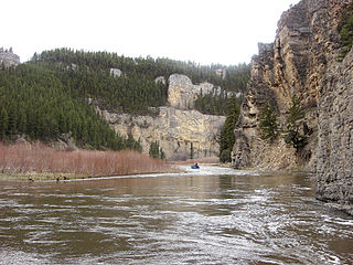
Mann Gulch is a gulch in the Gates of the Mountains Wilderness of the upper Missouri River, 24 miles (39 km) north-northeast of Helena, Montana, in southeastern Lewis and Clark County. It is on the east side of the Missouri River and approximately 9 miles (14 km) east of Interstate 15 (I-15), between Helena and Wolf Creek. Mann Gulch is between Meriwether Canyon immediately to the south and Rescue Gulch immediately to the north, and the creek it contains flows into the Missouri in the canyon known as the Gates of the Mountains. Mann Gulch is approximately 2.4 miles (3.9 km) southeast of Beartooth Mountain.
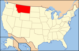
The following is an alphabetical list of articles related to the U.S. state of Montana.
The Little Belt Mountains are a section of the Rocky Mountains in the U.S. state of Montana. Situated mainly in the Lewis and Clark National Forest, the mountains are used for logging and recreation for the residents of Great Falls, Montana. Showdown is a ski area located within the mountains located off US Highway 89 which splits the mountains in half connecting White Sulphur Springs and Belt, MT. The highest point in the Little Belt Range is Big Baldy Mountain at 9,467 feet (2,886 m).

The Pryor Mountains are a mountain range in Carbon and Big Horn counties of Montana, and Big Horn County, Wyoming. They are located on the Crow Indian Reservation and the Custer National Forest, and portions of them are on private land. They lie south of Billings, Montana, and north of Lovell, Wyoming.

Holter Dam is a hydroelectric straight gravity dam on the Missouri River about 45 miles (72 km) northeast of Helena, Montana, in the United States. The dam, which was built between 1908 and 1918, is 1,364 feet (416 m) long and 124 feet (38 m) high. The reservoir formed by the dam, Holter Lake is 25 miles (40 km) long and has a storage capacity of 243,000 acre-feet (300,000,000 m3) of water when full. The dam is a "run-of-the-river" dam because it can generate electricity without needing to store additional water supplies behind the dam.
Sleeping Giant Wilderness Study Area is a non-motorized recreation area located on the west side of the Missouri River and Holter Lake located about 30 miles (48 km) north of Helena, Montana. Designated as a wilderness study area in 1981, the Sleeping Giant Wilderness Study Area contains approximately 6,666 acres (2,698 ha) of nearly roadless land, about half of which is forested. A portion of the Lewis and Clark National Historic Trail is contained inside the study area.

Tower Rock State Park is a state park near the community of Cascade in the U.S. state of Montana in the United States. The centerpiece of the park is Tower Rock, a 424-foot (129 m)-high rock formation which marks the entrance to the Missouri River Canyon in the Adel Mountains Volcanic Field. It was well known to Native Americans, and considered a sacred place by the Piegan Blackfeet. Tower Rock received its current name when Meriwether Lewis of the Lewis and Clark Expedition visited the site in 1805. Railroad and highway development in the late 1800s and 1900s skirted Tower Rock, but the landform itself remained pristine. The 87.2 acres (0.353 km2) encompassing Tower Rock was added to the National Register of Historic Places on March 18, 2002. The 140-acre (0.57 km2) Tower Rock State Park was created around the National Historic Site in 2004.


