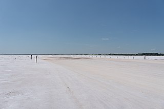
The Salt Plains National Wildlife Refuge is part of the United States system of national wildlife refuges. It is located in Alfalfa County in northern Oklahoma, north of Jet, along Great Salt Plains Lake, which is formed by a dam on the Salt Fork of the Arkansas River.

Browns Park National Wildlife Refuge is a 13,450-acre (5,440 ha) U.S. National Wildlife Refuge located in northwestern Colorado. It is located in Moffat County in the extreme northwestern corner of the state, in an isolated mountain valley of Browns Park on both sides of the Green River, approximately 25 miles (40 km) below Flaming Gorge Dam. Established in 1965, the refuge is managed by the United States Fish and Wildlife Service office in Maybell, Colorado. The refuge is approximately 53 miles (85 km) northwest of Maybell on State Highway 318. The refuge consists of bottomland and adjacent benchland. The western border of the refuge is the Colorado-Utah state line. The refuge is surrounded by adjacent lines of the Bureau of Land Management. The refuge contains the site of the former Fort Davy Crockett that was constructed in 1837 to protect trappers against attacks by Blackfoot Native Americans.
The Charles M. Russell National Wildlife Refuge is a National Wildlife Refuge in the U.S. state of Montana on the Missouri River. The refuge surrounds Fort Peck Reservoir and is 915,814 acres (3,706.17 km2) in size. It is the second-largest National Wildlife Refuge in the lower 48 states of the United States, and the largest in Montana. Created in 1936, it was originally called the Fort Peck Game Range. It was renamed in 1963 after Montana artist Charles M. Russell, a famous painter of the American West. In 1976, the "range" was made a "refuge".

The Billy Frank Jr. Nisqually National Wildlife Refuge is a wildlife preserve operated by the United States Fish and Wildlife Service on the Nisqually River Delta near Puget Sound in northeastern Thurston County, Washington and northwestern Pierce County, Washington. The refuge is located just off Interstate 5, between the cities of Tacoma and Olympia.

The Lower Klamath National Wildlife Refuge is a National Wildlife Refuge of the United States on the border between California and Oregon. It is operated by the United States Fish and Wildlife Service. The refuge was designated a National Historic Landmark on October 16, 1965.

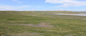
War Horse National Wildlife Refuge, located in the center of the U.S. state of Montana, is divided into three separate sections, with each centered on a small body of water. It is an integral part of the Charles M. Russell National Wildlife Refuge Complex, although the refuge is normally unstaffed and has few visitor improvements. One reservoir is stocked with rainbow trout, although the lake is sometimes empty. When the lakes and reservoirs are fully filled, the refuge provides excellent habitat for migratory bird species. The region is surrounded by sagebrush plains and Ponderosa pine groves that flourish in the region solely due to its acid-shale soils. Along with over 100 bird species, regular inhabitants include Sage Grouse, pronghorn and mule deer.
The Grand Cote National Wildlife Refuge was established in 1989 as part of the North American Waterfowl Management Plan. It is a 6,000-acre (24 km2) reserve located in Avoyelles Parish, near Marksville, Louisiana, in the United States.

Minidoka National Wildlife Refuge is located on the Snake River Plain in south-central Idaho, 12 miles (19 km) northeast of Rupert. It includes about 80 miles (130 km) of shoreline around Lake Walcott, from Minidoka Dam upstream about 25 miles (40 km).
Susquehanna River National Wildlife Refuge is located on a small island 3.79 acres (15,300 m2) in size located at the mouth of the Susquehanna River in Harford County, Maryland. It is a satellite refuge managed by Blackwater National Wildlife Refuge. In the 1920s, the island was used as a fish hatchery to produce such species as shad.

Hagerman National Wildlife Refuge (HNWR), a haven for migratory birds and other wildlife, lies in northwestern Grayson County, Texas, on the Big Mineral Arm of Lake Texoma, on the Red River between Oklahoma and Texas. This National Wildlife Refuge is made up of water, marsh, and upland habitat. Visitors can hike, observe wildlife, hunt, and fish throughout the year.

Columbia National Wildlife Refuge is a scenic mixture of rugged cliffs, canyons, lakes, and sagebrush grasslands. Formed by fire, ice, floods, and volcanic tempest, carved by periods of extreme violence of natural forces, the refuge lies in the middle of the Drumheller Channeled Scablands of central Washington. The area reveals a rich geologic history highlighted by periods of dramatic activity, each playing a major role in shaping the land. The northern half of the refuge, south of Potholes Reservoir, is a rugged jumble of cliffs, canyons, lakes, and remnants of lava flows. This part of the Scablands, known as the Drumheller Channels, is the most spectacularly eroded area of its size in the world and was designated as a National Natural Landmark in 1986.
McNary National Wildlife Refuge is a wildlife preserve, one of the national wildlife refuges operated by the United States Fish and Wildlife Service. Extending along the east bank of the Columbia River in southeastern Washington, from the confluence of the Snake River to the mouth of the Walla Walla River, and downstream into Oregon, McNary NWR is located in rural Burbank, but very close to the rapid development of the Tri-Cities. In fact, the refuge meets the definition of an "urban refuge." Few areas in North America support waterfowl populations in the extraordinary numbers found here. There are spectacular concentrations of Canada geese, mallards, and other waterfowl. More than half the mallards in the Pacific Flyway overwinter at some time in this portion of the Columbia River Basin.

The Umatilla National Wildlife Refuge is located on and around the Columbia River about 15 miles (24 km) northwest of Hermiston, Oregon and includes 8,907 acres (3,605 ha) in Oregon, and 14,876 acres (6,020 ha) in Washington. It was established in 1969 to help mitigate habitat lose due to the flooding that occurred following the construction of the John Day Dam. The refuge is popular with birdwatchers and wildlife enthusiasts.
Cold Springs National Wildlife Refuge is a 3,117-acre (12.61 km2) National Wildlife Refuge located 7 miles (10 km) northeast of Hermiston and 3 miles (5 km) south of the Columbia River in Umatilla County, Oregon; The refuge was established in 1909 as a preserve and breeding ground for native birds. It consists of diverse wetland habitats surrounded by upland habitat of big sagebrush and native steppe grasses. A riparian component of willow and cottonwood provides refuge for birds, mammals, and other animals.

McKay Creek National Wildlife Refuge is a United States National Wildlife Refuge located between plains and the Blue Mountains of Eastern Oregon. The refuge provides habitat for rare and endangered species and breeding and migratory birds. The lack of other local wetland habitats elevates the importance of this refuge as a home to a variety of wildlife and plant species in an arid environment.
Upper Souris National Wildlife Refuge, located 30 miles (48 km) northwest of Minot, North Dakota, was established in 1935 as a refuge and breeding ground for migratory birds and other wildlife. The refuge straddles 35 miles (56 km) of the picturesque Souris River valley in northern North Dakota. The Souris River basin figures prominently in the cultural and natural history of the North American mid-continent plains and prairies.
Long Lake National Wildlife Refuge, located in south-central North Dakota, was established in 1932 as a migratory bird refuge by President Herbert Hoover. The 22,300-acre (90 km2) refuge consists of a 15,000-acre (61 km2) saline basin that is 18 miles (29 km) long and is appropriately named "Long Lake." Long Lake is relatively shallow; it is normally 3–4 feet (0.91–1.22 m) deep. During extended wet periods, Long Lake reaches depths up to 7 feet (2.1 m).
The Merced National Wildlife Refuge encompasses 10,262 acres (41.53 km2) of wetlands, native grasslands, vernal pools, and riparian areas in California. It was established in 1951 under the Lea Act to attract wintering waterfowl from adjacent farmland where their foraging was causing crop damage. In the last few decades, changes in agricultural practices and refuge management have reduced these wildlife/crop issues.

The Summer Lake Wildlife Area is a 29.6-square-mile (77 km2) wildlife refuge located on the northwestern edge of the Great Basin drainage in south-central Oregon. It is administered by the Oregon Department of Fish and Wildlife. The refuge is an important stop for waterfowl traveling along the Pacific Flyway during their spring and fall migrations. The Summer Lake Wildlife Area also provides habitat for shorebirds and other bird species as well as wide variety of mammals and several fish species. The Ana River supplies the water for the refuge wetlands.

Kirwin Reservoir is a reservoir in Phillips County, Kansas, United States. It is located next to the city of Kirwin in northern Kansas. The U.S. Bureau of Reclamation built it and continues to operate it for the purposes of flood control and area irrigation. The Kirwin National Wildlife Refuge lies on its shores.