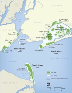
Gateway National Recreation Area is a 26,607-acre (10,767 ha) U.S. National Recreation Area in New York City and Monmouth County, New Jersey. It provides recreational opportunities that are rare in a dense urban environment, including ocean swimming, bird watching, boating, hiking and camping. Ten million people visit Gateway annually.

Southwick Beach State Park is a New York State park that lies along an unusual stretch of sandy beach on the eastern shore of Lake Ontario. The park is 464 acres (188 ha) in size with a 3,500 foot (1,100 m) length of beach, and is visited annually by about 100,000 people. Immediately to the south is the Lakeview Wildlife Management Area, which extends the publicly accessible beach by several miles. They are in the Town of Ellisburg in Jefferson County, New York south of the lakeside community of Jefferson Park.

P.J. Hoffmaster State Park is a public recreation area on the shores of Lake Michigan located five miles north of Grand Haven at the southwest corner of Norton Shores, in Muskegon County, and the northwest corner of Spring Lake Township, in Ottawa County, in the U.S. state of Michigan. It is operated by the Michigan Department of Natural Resources. The state park includes 1,200 acres (490 ha) of land including 3 miles (5 km) of sand beach on the lake. The park is named after P.J. Hoffmaster, sometimes considered the founder of the Michigan state parks system, who served as the Superintendent of State Parks and Director of the Department of Conservation. The park's nature center is named for Emma Genevieve Gillette, who scouted locations for new state parks under Hoffmaster.
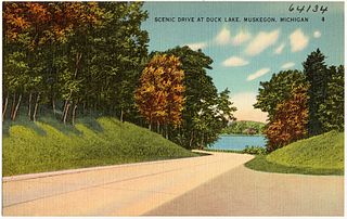
Duck Lake State Park is a public recreation area covering 728 acres (295 ha) along Lake Michigan five miles (8.0 km) southwest of Whitehall in Muskegon County, Michigan. The state park, which runs along the north side of Duck Lake to Lake Michigan, features a large sand dune. The park's Scenic Drive is part of the Shoreline Trail route in Muskegon County.

Wilderness State Park is a public recreation area bordering Lake Michigan, five miles southwest of Mackinaw City in Emmet County in Northern Michigan. The state park's 10,512 acres (4,254 ha) include 26 miles (42 km) of shoreline, diverse forested dune and swale complexes, wetlands, camping areas, and many miles of hiking trails. The state park is operated by the Michigan Department of Natural Resources, which has, as of 2006, approved a proposal that 4,492 acres (1,818 ha) be officially dedicated as a wilderness area. Wilderness State Park was designated a Michigan "dark sky preserve" in 2012.

Cheboygan State Park is a public recreation area covering 1,250 acres (510 ha) on the shores of Lake Huron in Cheboygan County, Michigan, United States. The state park offers views of the Fourteen Foot Shoal Light and the remains of the 1859 Cheboygan Point Light plus a distant view of the Poe Reef Light, some six miles to the northeast.

Fisherman's Island State Park is public recreation area of 2,678 acres (1,084 ha) sitting on six miles (9.7 km) of the Lake Michigan shoreline southwest of Charlevoix, Michigan. Due to historically low lake levels, for most of 1998 to 2016 the small Fisherman Island, for which the state park was named, had become attached to the mainland via a tombolo.

William Mitchell State Park is a public recreation area covering 334 acres (135 ha) within the city limits of Cadillac, Michigan. The state park is located between Lake Mitchell and Lake Cadillac in northern lower Michigan. The historic Clam Lake Canal, approximately one-third of a mile in length, connects the two lakes and runs directly through the park. The park is home to Carl T. Johnson Hunting and Fishing Center which documents the history of hunting and fishing, offers seminars, workshops and audio-visual presentations, and includes an exhibit hall which displays local wildlife species.
South Higgins Lake State Park is a public recreation area covering 1,000 acres (400 ha) on the southern shore of Higgins Lake five miles southwest of Roscommon in Roscommon County, Michigan. The state park occupies one mile of shoreline on Higgins Lake and entirely surrounds Marl Lake.

William W. Powers State Recreation Area is an Illinois state park administered by the Illinois Department of Natural Resources on 580 acres (230 ha) in the Hegewisch community area of the City of Chicago in Cook County, Illinois, United States. The area includes 419 acres (170 ha) of water in Wolf Lake that provides about 6 miles (10 km) of shoreline to fishermen. The park hosts about half a million visitors annually. The park contains numerous species, and is one of the most important biological sites in the Chicago region.

Tobico Marsh, located just north of Bay City, Michigan, is part of the Bay City Recreation Area. Tobico Marsh was designated as a registered National Natural Landmark in 1976 because of its large size, relatively undisturbed condition and variety of aquatic plant life. With nearly 2,000 acres (8.1 km2) of wetland woods, wet meadows, cattail marshlands and oak savannah prairies, Tobico Marsh is one of the largest remaining freshwater, coastal wetlands on the Great Lakes.

Seven Lakes State Park is a public recreation area covering 1,434 acres (580 ha) one mile northwest of Holly in Holly Township, Oakland County, Michigan. The state park's 230 acres (93 ha) of water are found in six named lakes that include 170-acre Big Seven Lake, Little Seven Lake, and 44-acre Dickinson Lake.

Dameron Marsh Natural Area Preserve is a 316-acre (128 ha) Natural Area Preserve located in Northumberland County, Virginia. It is one in a series of protected areas lining the shores of the Chesapeake Bay, and contains one of the region's most significant wetlands for marsh-bird habitats. Its pristine beaches serve as a home for the northeastern beach tiger beetle. Some of the land had been used in the past for agriculture, however these former fields were restored to forest through the combined efforts of the Virginia Department of Conservation and Recreation, The Nature Conservancy, and the United States Army Corps of Engineers.
The Dotson Family Marsh, formerly Breuner Marsh, is a 238-acre regional park on San Pablo Bay in the East San Francisco Bay Area city of Richmond, California, In 2009 the East Bay Regional Parks District acquired the Breuner Marsh site, adding it to Point Pinole Regional Shoreline. A habitat restoration plan for 60 acres of wetlands and 90 acres of California coastal prairie was subsequently approved.

New York State Wildlife Management Areas (WMAs) are conservation areas managed by the New York State Department of Environmental Conservation (NYSDEC) primarily for the benefit of wildlife, and used extensively by the public for hunting, fishing, and trapping. As of 2016, the NYSDEC owns and maintains 113 WMAs, with a total area of approximately 197,000 acres. The Wildlife Management Areas program is administered by the Division of Fish, Wildlife and Marine Resources of the NYSDEC.

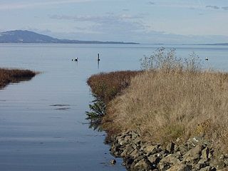
Black Pond Wildlife Management Area is a 526-acre (213 ha) New York State Wildlife Management Area (WMA) that lies on the eastern shore of Lake Ontario, and at the northern limit of an unusual region of sandy barrier beaches and lagoons. Much of the barrier beach in Black Pond WMA has forested sand dunes that are about 60 feet (18 m) high; these are the highest sand dunes in the northeast United States excepting Cape Cod. Immediately north of the WMA is the 360-acre (150 ha) El Dorado Beach Preserve, which is a bird refuge owned by The Nature Conservancy. North of the outlet from Black Pond to Lake Ontario, the shoreline is a weathered, flat bedrock shelf that is "calcareous" instead of sandy.
Rockport State Recreation Area is a 4,237-acre (17.15 km2) state park located along the shore of Lake Huron in Alpena and Presque Isle counties in the state of Michigan. It is operated by the Michigan Department of Natural Resources and was established in 2012. The park contains limestone formations and an old limestone quarry. There is a deep water boat launch that can accommodate all sizes of watercraft. The park is located along the Lake Huron Flyway and is used to gauge the health of Lake Huron and its shoreline environment. Several ship wrecks can be found off-shore in the Thunder Bay National Marine Sanctuary including the Portland and the Portsmouth. The park was previously known as "The Rockport property" and is not far north of Alpena, Michigan.
William H. Haithco Recreation Area is a 76-acre (31 ha) public park in Saginaw Charter Township, Michigan maintained by the Saginaw County Parks and Recreation Commission.

Michigan has about 242 streams with a combined length of 36,350 miles (58,500 km) and about 11,000 lakes and ponds. Michigan borders four of the five Great Lakes and is a signatory to the Great Lakes Compact. The Michigan Department of Environmental Quality is responsible for the management of Michigan's water resources.