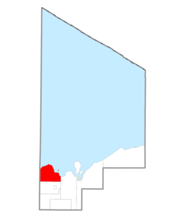
Whitefish Township is a civil township of Chippewa County in the U.S. state of Michigan. The population was 575 at the 2010 census.
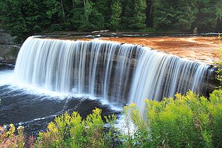
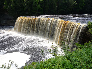
The Tahquamenon Falls are two different waterfalls on the Tahquamenon River. Both sets are located near Lake Superior in the eastern Upper Peninsula of Michigan. The water is notably brown in color from the tannins leached from the cedar swamps which the river drains. The upper falls are more than 200 feet across and with a drop of approximately 48 feet During the late spring runoff, the river drains as much as 50,000 US gallons (190,000 L) of water per second, making the upper falls the third most voluminous vertical waterfall east of the Mississippi River, after Niagara Falls and Cohoes Falls, both in New York State.
Gorges State Park is a 7,709-acre (31.20 km2) North Carolina state park in Transylvania County, North Carolina in the United States. The land, along Jocassee Gorges, was purchased by the state from Duke Energy Corporation in 1999. It is North Carolina's westernmost state park and one of the state's newest. The park is adjacent to part of the Pisgah National Forest and the N.C. Wildlife Resources Commission's Toxaway Game Land. Gorges State Park provides the principal access to the Horsepasture River on these adjoining public lands.

Pictured Rocks National Lakeshore is a U.S. National Lakeshore on the shore of Lake Superior in the Upper Peninsula of Michigan, United States. It extends for 42 miles (67 km) along the shore and covers 73,236 acres. The park has extensive views of the hilly shoreline between Munising and Grand Marais in Alger County, Michigan, with picturesque rock formations, waterfalls, and sand dunes.

The Porcupine Mountains, or Porkies, are a group of small mountains spanning the northwestern Upper Peninsula of Michigan in Ontonagon and Gogebic counties, near the shore of Lake Superior. The Porcupine Mountains were named by the native Ojibwa people, supposedly because their silhouette had the shape of a crouching porcupine. They are home to the most extensive stand of old growth northern hardwood forest in North America west of the Adirondack Mountains, spanning at least 31,000 acres (13,000 ha). In these virgin forests, sugar maple, American basswood, eastern hemlock, and yellow birch are the most abundant tree species. The area is part of the Porcupine Mountains Wilderness State Park.

Rock Island State Park is a state park in Warren County and White County, Tennessee, located in the Southeastern United States. The park is named after the community of Rock Island, Tennessee, which in turn received its name from an island on the Caney Fork upstream from the Collins River confluence and Great Falls Dam. Rock Island State Park is centered on a peninsula created by the confluence of these two rivers and extends downstream to the headwaters of Center Hill Lake.

Tettegouche State Park, in the United States, is a Minnesota state park on the north shore of Lake Superior 58 miles (93 km) northeast of Duluth in Lake County on scenic Minnesota Highway 61. The park's name stems from the Tettegouche Club, an association of local businessmen which purchased the park in 1910 from the Alger-Smith Lumber Company. The club's members protected the area until its sale in 1971 to the deLaittres family. In 1979, the state of Minnesota acquired 3,400 acres (1,400 ha) from the Nature Conservancy, including Tettegouche Camp. The land was added to Baptism River State Park, which was renamed Tettegouche State Park.
Bond Falls is a waterfall on the middle branch of the Ontonagon River, a few miles east of Paulding in Haight Township in southern Ontonagon County, Michigan. The site is near U.S. Highway 45 in the western portion of the Upper Peninsula of Michigan. The waterfalls are listed by the state of Michigan as the Bond Falls Scenic Site.

Judge C. R. Magney State Park is a state park of Minnesota, USA, on the North Shore of Lake Superior. It was named for Clarence R. Magney, a former mayor of Duluth and judge on the Minnesota Supreme Court, who was instrumental in getting 11 state parks and scenic waysides established along the North Shore. The park is best known for the Devil's Kettle, an unusual waterfall and rock formation in which half of the Brule River disappears into a pothole.

The Tahquamenon Falls State Park is a 46,179-acre (186.88 km2) state park in the U.S. state of Michigan. It is the second largest of Michigan's state parks. Bordering on Lake Superior, most of the park is located within Whitefish Township in Chippewa County, with the western section of the park extending into McMillan Township in Luce County. The nearest town of any size is Paradise.

M-123 is a state trunkline highway in the eastern Upper Peninsula of the U.S. state of Michigan. It is one of only a few highways in Michigan that curve around and form a U-shape. In fact, M-123 has three intersections with only two state trunklines; it meets M-28 twice as a result of its U-shaped routing. M-123 also has a rare signed concurrency with a County-Designated Highway in Michigan; in Trout Lake, there is a concurrency with H-40. All of M-123 north of M-28 is a Scenic Heritage Route within the Michigan Heritage Route system.
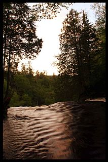
The Tahquamenon River is an 89.1-mile-long (143.4 km) blackwater river in the U.S. state of Michigan that flows in a generally eastward direction through the eastern end of the Upper Peninsula. It drains approximately 820 square miles (2,120 km2) of the Upper Peninsula, including large sections of Luce County and Chippewa County. It begins in the Tahquamenon Lakes in northeast Columbus Township of Luce County and empties into Lake Superior near the village of Paradise. M-123 runs alongside a portion of the river.

Chimney Rock State Park is a North Carolina state park in Chimney Rock, Rutherford County, North Carolina in the United States. The 6,807-acre (27.55 km2) park is located 25 miles (40 km) southeast of Asheville, North Carolina, and is owned by the state of North Carolina.

The Agate Falls Scenic Site is a waterfall and scenic site located in Interior Township, in southeastern Ontonagon County, Michigan. The waterfall is 7 miles (11 km) southeast of Bruce Crossing, Michigan on the state highway M-28.

The Wagner Falls Scenic Site is a Michigan State Park, located in central Alger County, Upper Michigan. The 23-acre (0.1 km²) state scenic area protects Wagner Falls.

High Cliff State Park is a 1,187-acre (480 ha) Wisconsin state park near Sherwood, Wisconsin. It is the only state-owned recreation area located on Lake Winnebago. The park got its name from cliffs of the Niagara Escarpment, a land formation east of the shore of Lake Winnebago that stretches north through northeast Wisconsin, Upper Michigan, and Ontario to Niagara Falls and New York State.
Wagner Falls is a waterfall on Wagner Creek near Munising, in Alger County, Upper Michigan. They are in the Wagner Falls Scenic Site, a Michigan State Park of the Michigan Department of Natural Resources.
There are three Manistique Lakes in the Upper Peninsula of Michigan. The lakes include North Manistique Lake, Big Manistique Lake, and South Manistique Lake. The towns surrounding the lakes are Curtis Township, Germfask, and Helmer. The lakes are known for vacationing and fishing. They are also in close proximity to other natural sights such as the Great Lakes, rivers, and smaller lakes as well as tourist attractions including the Canada–US border, the Soo Locks, Mackinac Island, parks, and museums.