
Death Valley National Park is an American national park that straddles the California–Nevada border, east of the Sierra Nevada. The park boundaries include Death Valley, the northern section of Panamint Valley, the southern section of Eureka Valley and most of Saline Valley. The park occupies an interface zone between the arid Great Basin and Mojave deserts, protecting the northwest corner of the Mojave Desert and its diverse environment of salt-flats, sand dunes, badlands, valleys, canyons and mountains. Death Valley is the largest national park in the contiguous United States, as well as the hottest, driest and lowest of all the national parks in the United States. It contains Badwater Basin, the second-lowest point in the Western Hemisphere at 282 feet (86 m) below sea level. More than 93% of the park is a designated wilderness area. The park is home to many species of plants and animals that have adapted to this harsh desert environment including creosote bush, Joshua tree, bighorn sheep, coyote, and the Death Valley pupfish, a survivor from much wetter times. UNESCO included Death Valley as the principal feature of its Mojave and Colorado Deserts Biosphere Reserve in 1984.

The Great Basin is the largest area of contiguous endorheic watersheds in North America. It spans nearly all of Nevada, much of Oregon and Utah, and portions of California, Idaho, Wyoming, and Baja California, Mexico. It is noted for both its arid climate and the basin and range topography that varies from the North American low point at Badwater Basin in Death Valley to the highest point of the contiguous United States, less than 100 miles (160 km) away at the summit of Mount Whitney. The region spans several physiographic divisions, biomes, ecoregions, and deserts.

The Sevier River is a 385-mile (620 km)-long river in the Great Basin of southwestern Utah in the United States. Originating west of Bryce Canyon National Park, the river flows north through a chain of high farming valleys and steep canyons along the west side of the Sevier Plateau, before turning southwest and terminating in the endorheic basin of Sevier Lake in the Sevier Desert. It is used extensively for irrigation along its course, with the consequence that Sevier Lake is usually dry.

The Santa Rosa Mountains are a short mountain range in the Peninsular Ranges system, located east of the Los Angeles Basin and northeast of the San Diego metropolitan area of southern California, in the southwestern United States.
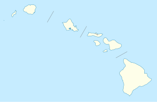
Haleakalā National Park is an American national park located on the island of Maui in the state of Hawaii. Named after Haleakalā, a dormant volcano within its boundaries, the park covers an area of 33,265 acres, of which 24,719 acres is a wilderness area. The land was designated a national park in 1976 and its boundaries expanded in 2005.

The City of Rocks National Reserve, also known as the Silent City of Rocks, is a United States National Reserve and state park in south-central Idaho, approximately 2 miles (3.2 km) north of the border with Utah. It is widely known for its enormous granite rock formations and excellent rock climbing.

The Three Sisters Wilderness is a wilderness area in the Cascade Range, within the Willamette and Deschutes National Forests in Oregon, United States. It comprises 286,708 acres (1,160.27 km2), making it the second largest wilderness area in Oregon, after the Eagle Cap Wilderness. It was established by the United States Congress in 1964 and is named for the Three Sisters volcanoes. The wilderness boundary encloses the Three Sisters as well as Broken Top, which is southeast of South Sister.

The Coast Ranges of California span 400 miles (644 km) from Del Norte or Humboldt County, California, south to Santa Barbara County. The other three coastal California mountain ranges are the Transverse Ranges, Peninsular Ranges and the Klamath Mountains.

The Santa Rosa and San Jacinto Mountains National Monument is a National Monument in southern California. It includes portions of the Santa Rosa and San Jacinto mountain ranges, the northernmost ones of the Peninsular Ranges system. The national monument covers portions of Riverside County, west of the Coachella Valley, approximately 100 miles (160 km) southeast of downtown Los Angeles.
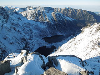
Tatra National Park is a National Park located in the Tatra Mountains in Tatra County, in the Lesser Poland Voivodeship—Małopolska region, in central-southern Poland. The Park has its headquarters in the town of Zakopane.

The Snake Range is a mountain range in White Pine County, Nevada, United States. The south-central portion of the range is included within Great Basin National Park, with most of the remainder included within the Humboldt-Toiyabe National Forest. The range reaches a maximum elevation of 13,065 feet (3,982 m) at the summit of Wheeler Peak, the tallest independent mountain within Nevada and the second highest point within the state. The range also contains four of the five highest mountain peaks in Nevada, including all peaks greater than 12,000 feet (3,658 m) except for Boundary Peak.

The geography of the U.S. State of Colorado is diverse, encompassing both rugged mountainous terrain, vast plains, desert lands, desert canyons, and mesas. In 1861, the United States Congress defined the boundaries of the new Territory of Colorado exclusively by lines of latitude and longitude, stretching from 37°N to 41°N latitude, and from 102°02'48"W to 109°02'48"W longitude. Starting in 1868, official surveys demarcated the boundaries, deviating from the parallels and meridians in several places. Later surveys attempted to correct some of these mistakes but in 1925 the U.S. Supreme Court affirmed that the earlier demarcation was the official boundary. The borders of Colorado are now officially defined by 697 boundary markers connected by straight boundary lines. Colorado, Wyoming, and Utah are the only states that have their borders defined solely by straight boundary lines with no natural features. The southwest corner of Colorado is the Four Corners Monument at 36°59'56"N, 109°2'43"W. This is the only place in the United States where four states meet: Colorado, New Mexico, Arizona, and Utah.

Tule Valley is a valley in Millard County, Utah, United States.
Tule is a plant of the sedge family.

The Antelope Valley of southwest Millard County, Utah, United States, is a small 25-mile (40 km) long valley, adjacent the Ferguson Desert and 40 miles (64 km) southwest of Sevier Lake. The valley is just east of the Nevada border, with Snake Valley and the Burbank Hills. The other Antelope Valley of Utah occurs 165 miles (266 km) east in the Great Basin, in southeast Emery County and extending into adjacent Wayne County.
The Canyon Mountains are a 25-mile (40 km) long mountain range located in the northeast corner of Millard County, Utah; the range is bisected north-south with a southeast border section of Juab County.

The San Francisco Mountains are a 20-mile-long (32 km) mountain range located in north‑central Beaver County, Utah, United States that extend into central-south Millard County.

for other uses, see Pine Valley (disambiguation)

The Fraser Biosphere Reserve and Experimental Forest is a former UNESCO Biosphere Reserve situated on the west side of the Continental Divide in north-central Colorado and includes the entire watershed of Main St. Louis Creek, a tributary of the Fraser River.


