
The Faroe Islands is served by an internal transport system based on roads, ferries, and helicopters. As of the 1970s, the majority of the population centres of the Faroe Islands have been joined to a single road network, connected by bridges and tunnels.
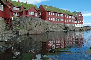
Tórshavn, usually locally referred to as simply Havn, is the capital and largest city of the Faroe Islands. It is located in the southern part on the east coast of Streymoy. To the northwest of the city lies the 347-meter-high (1,138 ft) mountain Húsareyn, and to the southwest, the 350-meter-high (1,150 ft) Kirkjubøreyn. They are separated by the Sandá River. The city itself has a population of 14,099 (2024), and the greater urban area has a population of 23,194, including the suburbs of Hoyvík and Argir.
B36 Tórshavn is a Faroese football club based in the capital of Tórshavn, playing in the Faroe Islands Premier League, the top tier of Faroese football. B36 Tórshavn has always played its home games in Gundadalur.

Argir is a village in the Faroe Islands.
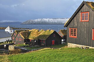
Kirkjubøur is the southernmost village on Streymoy, Faroe Islands. The village is located on the south-west coast of Streymoy and has a view towards the islands of Hestur and Koltur towards the west, and to Sandoy towards the south. It lies south of the new ferry port of Gamlarætt, which opened in 1993.

Nólsoy is an island and village with a population of 230 people in central Faroe Islands, 4km east of the capital Tórshavn in Streymoy.

Streymoy is the largest and most populated island of the Faroe Islands. The capital, Tórshavn, is located on its southeast coast. The name means "island of currents". It also refers to the largest region of the country that also includes the islands of Hestur, Koltur and Nólsoy.

The Catholic Church in the Faroe Islands goes back to the year 999, when king Olav Tryggvason of Norway sent Sigmundur Brestisson on a mission to the islands with several priests. The islands became an independent diocese in 1111, but were officially reformed in 1537 and the last Catholic bishop was executed in 1538. After 1538, the Catholic Church was only revived in 1931 as a part of the bishopric of Copenhagen. The state church is now the Protestant Faroese People's Church.
Posta is the postal service of the Faroe Islands and was founded on 1 April 1976 under the Home Rule of the Faroe Islands. On 16 December 2005, it became a public joint stock company under the name P/F Postverk Føroya.

Tórshavn Municipality is the municipality of the Faroese capital Tórshavn and its surroundings.

Velbastaður is a village on the island of Streymoy in the Faroe Islands. It is a part of Tórshavn Municipality and is considered among the oldest settlements in the islands. There are two schools and one kindergarten in the village, with children coming from the neighboring village of Kirkjubø as well the capital at Tórshavn.
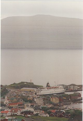
Smyril Line is a Faroese shipping company, linking the Faroe Islands with Denmark, Iceland, the Netherlands and Lithuania. It previously also served Norway and the United Kingdom. Smyril is the Faroese word for the merlin.

Kollafjørður is a village in the Faroe Islands, located on the island of Streymoy. As of 1. January 2024, the village had a population of 813. Its postal code is FO 410. Until 2001 it was a municipality in its own right but is now part of the Tórshavn Municipality. It is located 21.8 kilometres (13.5 mi) by road north of Tórshavn, and stretches 7 km (4.3 mi) along the fjord of the same name.

Jákup Dahl was a Faroese Provost and Bible translator. In 1908 he became known as a linguist with the first Faroese grammar lessons for school students.
Sámuel Joensen-Mikines (1906–1979) was a Faroese painter. He was the first recognised painter of the Faroe Islands and one of the Faroe Islands' most important artists. Many of his paintings have been displayed on Faroese stamps.
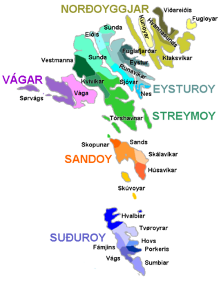
The Faroe Islands are administratively divided in 29 municipalities (kommunur), with about 120 cities and villages. Until December 31, 2008, there were 34 municipalities, and until December 31, 2004, there were 48 municipalities. In the coming years the number of Faroese municipalities is expected to drop to somewhere between 7 and 15, as there is currently a rationale towards municipal amalgamation and a decentralization of public services. In 1998 it was suggested that no municipality should have fewer than 2,000 inhabitants, but whether this will be true is a political question. The Faroese government has furthermore decided not to conduct forced, top-down amalgamation, but to leave the process to the free will of the municipalities. In many small municipalities there is some resistance to the amalgamation process, and as a result two kinds of municipalities are being created: large municipalities (town-municipalities) that are eager to attract smaller municipalities into amalgamation, and small municipalities which are either trying to avoid amalgamation or seek to amalgamate with other small municipalities. The geographically large Sunda municipality is an example of this. The larger municipalities are organized in Kommunusamskipan Føroya (KFS) and the smaller are organized in Føroya Kommunufelag (FKF).
The Faroe Islands Super Cup is a football competition contested between the Faroe Islands Premier League champions and the winners of the Faroe Islands Cup from the previous season.

The Eysturoy Tunnel is a large undersea road tunnel under the Tangafjørður sound in the Faroe Islands, connecting the island of Streymoy to the island of Eysturoy. It also crosses the southern part of Skálafjørður, and connects the towns of Runavík on the eastern side and Strendur on the western side of the fjord, and includes the world's first undersea roundabout in the middle of the network.

A settlement village is a settlement in the Faroe Islands that was founded during the 1800s or early 1900s. The population of the islands grew quickly from 1800 onward, resulting in a shortage of land in the older villages. Many new villages were established on the periphery of the older ones, and therefore few of the new villages contained state-owned leasehold land.
Tangafjørður is the southern part of the strait separating the islands of Streymoy and Eysturoy in the Faroe Islands. The northern part of the strait between is named Sundini.


