
Richfield is a town located in Otsego County, New York, United States. As of the 2010 census, the town had a population of 2,388. The Town of Richfield is located at the northern border of the county.

The Mohawk River is a 149-mile-long (240 km) river in the U.S. state of New York. It is the largest tributary of the Hudson River. The Mohawk flows into the Hudson in Cohoes, New York, a few miles north of the city of Albany. The river is named for the Mohawk Nation of the Iroquois Confederacy. It is a major waterway in north-central New York. The largest tributary, the Schoharie Creek, accounts for over one quarter (26.83%) of the Mohawk River's watershed. Another main tributary is the West Canada Creek, which makes up for 16.33% of the Mohawk's watershed.

The Chenango River is a 90-mile-long (140 km) tributary of the Susquehanna River in central New York in the United States. It drains a dissected plateau area in upstate New York at the northern end of the Susquehanna watershed.

The West Branch Delaware River is one of two branches that form the Delaware River. It is approximately 90 mi (144 km) long, and flows through the U.S. states of New York and Pennsylvania. It winds through a mountainous area of New York in the western Catskill Mountains for most of its course, before joining the East Branch along the northeast border of Pennsylvania with New York. Midway or so it is empounded by the Cannonsville Dam to form the Cannonsville Reservoir, both part of the New York City water supply system for delivering drinking water to the City.

Canadarago Lake is a 1,917-acre (7.76 km2) lake located in Otsego County, New York and is the source of Oaks Creek. The Village of Richfield Springs is located at the lake's northern end. It is the second largest lake in Otsego County, lying to the west of and parallel to the larger Otsego Lake. The lake's name is also spelled "Candajarago Lake" or "Caniadaraga Lake".

The Sacandaga River is a 64-mile-long (103 km) river in the northern part of New York in the United States. Its name comes from the Native American Sa-chen-da'-ga, meaning "overflowed lands".

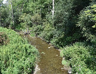
Oaks Creek is a river that drains Canadarago Lake, which is situated in the north central region of Otsego County, New York. The creek begins by the Hamlet of Schuyler Lake and flows southeast approximately 9.32 miles (15.00 km), dropping only 105 feet (32 m) in elevation, before converging with the Susquehanna River south of the Village of Cooperstown, by the Hamlet of Index. From the source to Oaksville the creek flows along Panther Mountain. Fly Creek is a main tributary, that converges with Oaks Creek south of the Hamlet of Fly Creek.

Hayden Creek is a river in Otsego County, in the U.S. State of New York. It begins north-northwest of the Hamlet of East Springfield and flows generally southward before flowing into Otsego Lake south of the Hamlet of Springfield Center.
Cripple Creek is a river in southern Herkimer County and northern Otsego County in the state of New York. It begins northeast of Warren and flows through Weaver Lake then Young Lake before flowing into Otsego Lake south of Springfield Center. Was formally referred to as Lawyers Creek.

Mink Creek or Otskonoga, also known as Trout Brook, is a stream in northern Otsego County, New York. Its source is adjacent to US Route 20 just east of the community of Brighton and west-northwest of the Village of Richfield Springs and flows northeast into an unnamed swamp in adjacent Herkimer County. It then exits the swamp and flows south back into Otsego County before converging with Canadarago Lake south of Richfield Springs. The Iroquois' name for the creek is Otskonoga.
Ocquionis Creek, also known as Fish Creek, is a river in southern Herkimer County and northern Otsego County in the State of New York. It begins northeast of the Hamlet of Jordanville and flows generally southward before flowing into the northern end of Canadarago Lake south of the Village of Richfield Springs. Ocquionis is an Iroquois word that translates to "he is a bear".
Herkimer Creek is a river in Otsego County in the state of New York. It begins west-southwest of the Hamlet of Richfield and northwest of the Hamlet of Dogtown and begins flowing mostly southeast before flowing into Canadarago Lake northeast of the Hamlet of Schuyler Lake.
Otsquago Creek is a river that enters the Mohawk River in Fort Plain, New York. Otsquago is a Mohawk Indian word meaning 'under the bridge,' probably referring to an early bridge of felled trees along the creek, a way of making small bridges. It is also referred to as Otsquage on old maps, which is an Indian word for 'healing waters'.

The Canajoharie Creek is a river that flows into the Mohawk River in the Village of Canajoharie in the U.S. State of New York. The name "Canajoharie" is a Mohawk language term meaning "the pot that washes itself", referring to the "Canajoharie Boiling Pot", a 20-foot (6.1 m) wide and 10-foot (3.0 m) deep pothole in the Canajoharie Creek, just south of the village of Canajoharie. Bowmans Creek is one main tributary that enters the creek east of the Hamlet of Sprout Brook. The other main tributary is Brimstone Creek which enters the creek north-northwest of the Village of Ames.
Flat Creek is a river in Schoharie and Montgomery counties in the state of New York. It begins east of Sharon Springs and flows in a general northward direction before flowing into the Mohawk River in Sprakers. Flat Creek Falls, also known as Sprakers Falls, is located on the creek by Sprakers. The indians referred to the creek as Onogerreah, and the mouth of the creek as Utlogowanke.
Steele Creek begins in an unnamed swamp south of Cedarville, New York, and flows northeast before emptying into the Mohawk River in the village of Ilion. Steele Creek travels through the Ilion Gorge and alongside NY-51 for most of its length. Steele Creek derives its name from Rudolph Stahl, who built the first grist mill in Ilion along the creek.
Caroga Creek is a river in Fulton and Montgomery counties in the U.S. State of New York. It begins at East Caroga Lake and flows south passing through Rockwood Lake before converging with the Mohawk River in the Hamlet of Palatine Church.
Cayadutta Creek is a river in Fulton and Montgomery counties in the state of New York. It begins northwest of Gloversville and flows in a general southward direction before flowing into the Mohawk River in Fonda. The Indian meaning of Cayadutta is "rippling waters" or "shallow water running over stones". This stream has commercial and historical importance as the cities of Johnstown and Gloversville lie on its banks.
Evas Kill is a river in Fulton and Montgomery counties in the state of New York. It flows into the Mohawk River in Cranesville. Evas Kill flows through Cranes Hollow.
Cincinnati Creek is a river in Oneida County in the state of New York. It begins southwest of the hamlet of Alder Creek, and flows into the West Canada Creek in Mapledale.

