Héroes Albarracín District

Last updated
Héroes Albarracín
District
Distrito HeroesAlbarracin.jpg
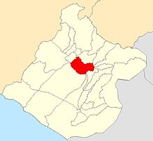
Location of Chucatamani in the Tarata Province
Country Flag of Peru.svg  Peru
Region Tacna
Province Tarata
Founded January 30, 1953
Capital Chucatamani
Government
   Mayor Fabian Sebastian Flores Choque
Area
  Total 372.41 km2 (143.79 sq mi)
Elevation 2,325 m (7,628 ft)
Population (2005 census)
  Total 447
  Density 1.2/km2 (3.1/sq mi)
Time zone PET (UTC-5)
UBIGEO 230402

Héroes Albarracín District (used to be "Chucatamani" District) is one of eight districts of the province Tarata in Peru. [1]

Districts of Peru third level administrative subdivision of Peru

The districts of Peru are the third-level country subdivisions of Peru. They are subdivisions of the provinces, which in turn are subdivisions of the larger regions or departments. There are 1,838 districts in total.

Tarata Province Province in Tacna, Peru

Tarata is one of four provinces in the Tacna Region in southern Peru. Its capital is Tarata city.

Peru republic in South America

Peru, officially the Republic of Peru, is a country in western South America. It is bordered in the north by Ecuador and Colombia, in the east by Brazil, in the southeast by Bolivia, in the south by Chile, and in the west by the Pacific Ocean. Peru is a megadiverse country with habitats ranging from the arid plains of the Pacific coastal region in the west to the peaks of the Andes mountains vertically extending from the north to the southeast of the country to the tropical Amazon Basin rainforest in the east with the Amazon river.

Related Research Articles

Camilaca District is one of six districts of the province Candarave in Peru.

Curibaya District is one of six districts of the province Candarave in Peru.

Quilahuani District is one of six districts of the province Candarave in Peru.

Alto de la Alianza District District in Tacna, Peru

Alto de la Alianza District is one of ten districts of the province Tacna in Peru.

Ciudad Nueva District is one of ten districts of the province Tacna in Peru.

Inclán District is one of ten districts of the province Tacna in Peru.

Pachía District is one of ten districts of the province Tacna in Peru.

Estique District is one of eight districts of the province Tarata in Peru.

Estique-Pampa District is one of eight districts of the province Tarata in Peru.

Sitajara District is one of eight districts of the province Tarata in Peru.

Tarata District District in Tacna, Peru

Tarata District is one of eight districts of the province Tarata in Peru.

Arapa District is one of fifteen districts of the province Azángaro in Peru.

Asillo District is one of fifteen districts of the province Azángaro in Peru.

San Anton District is one of fifteen districts of the Azángaro Province in Peru.

Lampa District, Lampa District in Puno, Peru

Lampa District is one of ten districts of the province Lampa in Peru.

Umachiri District is one of nine districts of the province Melgar in Peru.

Cabana District is one of four districts of the province San Román in Peru.

LP 658-2 is a degenerate star in the constellation of Orion, the single known object in its system. It has an apparent visual magnitude of approximately 14.488.

G 240-72 is a nearby degenerate star of spectral class DQP9.0, located in constellation Draco.

Jardim Helena Place in São Paulo, Brazil

Jardim Helena is one of 96 districts in the city of São Paulo, Brazil.

References

Coordinates: 17°28′49″S70°07′21″W / 17.4802°S 70.1225°W / -17.4802; -70.1225

Geographic coordinate system Coordinate system

A geographic coordinate system is a coordinate system that enables every location on Earth to be specified by a set of numbers, letters or symbols. The coordinates are often chosen such that one of the numbers represents a vertical position and two or three of the numbers represent a horizontal position; alternatively, a geographic position may be expressed in a combined three-dimensional Cartesian vector. A common choice of coordinates is latitude, longitude and elevation. To specify a location on a plane requires a map projection.