Palca District, Tacna

Last updated
Palca
P'allqa
Parroquia de Causuri - Palca.JPG
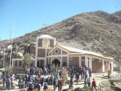
Church of Causuri near the village of Palca
Distrito Palca.jpg
Location of Palca in the Tacna province
Country Flag of Peru.svg  Peru
Region Tacna
Province Tacna
FoundedJune 8, 1959
Capital Palca
Government
   Mayor Hector Mamani Canaviri
Area
  Total
1,417.86 km2 (547.44 sq mi)
Elevation
2,935 m (9,629 ft)
Population
  Total
1,106
  Density0.78/km2 (2.0/sq mi)
Time zone UTC-5 (PET)
UBIGEO 230107

Palca District is one of ten districts of the province Tacna in Peru. [1]

Contents

Geography

The Barroso mountain range traverses the district. Some of the highest mountains of the district are listed below: [2]

Climate

Climate data for Palca, elevation 3,023 m (9,918 ft), (1991–2020)
MonthJanFebMarAprMayJunJulAugSepOctNovDecYear
Mean daily maximum °C (°F)17.9
(64.2)
17.8
(64.0)
18.4
(65.1)
19.3
(66.7)
19.4
(66.9)
19.7
(67.5)
19.3
(66.7)
19.8
(67.6)
19.8
(67.6)
19.6
(67.3)
19.0
(66.2)
18.3
(64.9)
19.0
(66.2)
Mean daily minimum °C (°F)8.9
(48.0)
8.9
(48.0)
8.7
(47.7)
7.8
(46.0)
6.8
(44.2)
6.3
(43.3)
5.8
(42.4)
6.6
(43.9)
7.4
(45.3)
8.2
(46.8)
8.2
(46.8)
8.6
(47.5)
7.7
(45.8)
Average precipitation mm (inches)25.6
(1.01)
30.9
(1.22)
12.7
(0.50)
0.1
(0.00)
0.4
(0.02)
0.1
(0.00)
0.8
(0.03)
0.5
(0.02)
0.3
(0.01)
0.2
(0.01)
0.1
(0.00)
7.2
(0.28)
78.9
(3.1)
Source: National Meteorology and Hydrology Service of Peru [3]
Climate data for Paucarani, Palca, elevation 4,625 m (15,174 ft), (1991–2020)
MonthJanFebMarAprMayJunJulAugSepOctNovDecYear
Mean daily maximum °C (°F)13.1
(55.6)
12.9
(55.2)
13.4
(56.1)
13.3
(55.9)
11.7
(53.1)
11.2
(52.2)
10.9
(51.6)
11.9
(53.4)
13.2
(55.8)
14.6
(58.3)
15.4
(59.7)
14.7
(58.5)
13.0
(55.5)
Mean daily minimum °C (°F)−1.5
(29.3)
−0.9
(30.4)
−2.3
(27.9)
−4.0
(24.8)
−5.8
(21.6)
−6.6
(20.1)
−7.4
(18.7)
−7.8
(18.0)
−6.3
(20.7)
−5.4
(22.3)
−5.0
(23.0)
−3.2
(26.2)
−4.7
(23.6)
Average precipitation mm (inches)97.0
(3.82)
91.0
(3.58)
58.1
(2.29)
13.7
(0.54)
1.8
(0.07)
3.4
(0.13)
1.2
(0.05)
2.2
(0.09)
1.2
(0.05)
4.9
(0.19)
11.2
(0.44)
40.8
(1.61)
326.5
(12.86)
Source: National Meteorology and Hydrology Service of Peru [3]

References

  1. (in Spanish) Instituto Nacional de Estadística e Informática. Banco de Información Distrital Archived 2008-04-23 at the Wayback Machine . Retrieved April 11, 2008.
  2. escale.minedu.gob.pe - UGEL map of the Tarata Province (Tacna Region)
  3. 1 2 "Normales Climaticás Estándares y Medias 1991-2020". National Meteorology and Hydrology Service of Peru. Archived from the original on 21 August 2023. Retrieved 6 November 2023.

17°46′41″S69°57′35″W / 17.7780°S 69.9597°W / -17.7780; -69.9597