
Interstate 35 (I-35) is a major Interstate Highway in the central United States. As with most primary Interstates that end in a five, it is a major cross-country, north–south route. It stretches from Laredo, Texas, near the Mexican border to Duluth, Minnesota, at Minnesota State Highway 61 and 26th Avenue East. The highway splits into I-35E and I-35W in two separate places, the Dallas–Fort Worth metroplex in Texas and at the Minnesota twin cities of Minneapolis–Saint Paul.
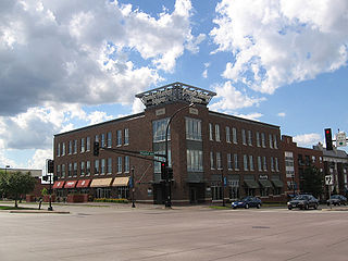
Burnsville is a city 15 miles (24 km) south of downtown Minneapolis in Dakota County, Minnesota. The city is situated on a bluff overlooking the south bank of the Minnesota River, upstream from its confluence with the Mississippi River. Burnsville and nearby suburbs form the southern portion of Minneapolis–Saint Paul, the 16th-largest metropolitan area in the United States, with about 3.7 million residents. At the 2020 census the population was 64,317.
Interstate 494 (I-494) is an auxiliary Interstate Highway making up part of a beltway of I-94, circling through the southern and western portions of the Minneapolis–Saint Paul metropolitan area in Minnesota. The 42.94-mile (69.11 km) road is coupled with I-694 at each end and composes more than half of the major beltway of the region. I-694/I-494 also act as loop routes for I-35E and I-35W.

Minnesota State Highway 36 (MN 36) is a 21.718-mile-long (34.952 km) highway in the U.S. state of Minnesota, which runs from its interchange with Interstate 35W (I-35W) in Roseville and continues east to its eastern terminus at the Wisconsin state line, where it becomes Wisconsin Highway 64 (WIS 64) upon crossing the St. Croix River at the St. Croix Crossing bridge. MN 36 is a major freeway in suburban Minneapolis–Saint Paul from its western terminus to its intersection with MN 120, at which point it becomes an at-grade expressway.

Interstate 694 (I-694) is an east–west auxiliary Interstate Highway located in the Minneapolis–Saint Paul metropolitan area in the US state of Minnesota. The western terminus of the route is at its junction with I-94, I-494, and US Highway 52 (US 52) in Maple Grove. The eastern terminus of I-694 is at its junction with I-94 and I-494 at the Woodbury–Oakdale city line. I-694 comprises the northern and northeastern portions of a beltway around the Twin Cities, with I-494 forming the remainder of the beltway. The speed limit is 60 mph (97 km/h). Interstate Highways outside of the loop in Minnesota may be signed as high as 70 mph (110 km/h) but can only reach 60 mph (97 km/h) inside the loop.
Minnesota State Highway 65 is a highway in the east–central and northeast parts of the U.S. state of Minnesota, which starts at its split from I-35W, skipping past the downtown Minneapolis core, only to resume at the intersection with Washington Avenue at the north end of downtown Minneapolis to continue north to its northern terminus at its intersection with U.S. Highway 71 (US 71) in Littlefork near International Falls.

The 10th Avenue Bridge crosses the Mississippi River near downtown Minneapolis, Minnesota and also in proximity to the University of Minnesota. The bridge was historically referred to as the Cedar Avenue Bridge in the days prior to the construction of the I-35W Mississippi River bridge when it connected to Cedar Ave. The bridge connects 10th Avenue Southeast, on the east side of the Mississippi River, to 19th Avenue South on the west side. The Seven Corners area of the Cedar-Riverside, Minneapolis neighborhood is at the southern end of the bridge. The downstream end of the lower Saint Anthony Falls lock and dam extends under the bridge. The historic Southeast Steam Plant is also located nearby.

County State-Aid Highway 42 (CSAH 42), usually called County Road 42 (CR 42), is a 33.347-mile-long (53.667 km) county highway in Dakota and Scott counties in the southeastern part of the U.S. state of Minnesota. It is a primary arterial highway in the two counties. These two counties form the southernmost portion of the 13-county Twin Cities metropolitan area, although CSAH 42 travels across the northern reaches of the two counties.

The Stillwater Bridge is a vertical-lift bridge crossing the St. Croix River between Stillwater, Minnesota, and Houlton, Wisconsin. It formerly connected Minnesota State Highway 36 and Wisconsin Highway 64. Around 18,000 vehicles crossed the bridge daily. The new St. Croix Crossing bridge crossing the St. Croix river valley to the south of Stillwater replaced its purpose, having opened to highway traffic on August 2, 2017, leaving the Stillwater Lift Bridge to be preserved and to be converted to bicycle/pedestrian use.

Interstate 35E (I-35E) is an Interstate Highway in the US state of Minnesota, passing through downtown Saint Paul. It is one of two through routes for I-35 through the Twin Cities of Minneapolis and Saint Paul, the other being I-35W through Minneapolis. Thus, both ends of I-35E are shared with I-35W and I-35.

Interstate 35W (I-35W) is an Interstate Highway in the US state of Minnesota, passing through downtown Minneapolis. It is one of two through routes for I-35 through the Twin Cities of Minneapolis and Saint Paul, the other being I-35E through downtown Saint Paul.
The Lafayette Bridge is a bridge carrying U.S. Route 52 across the Mississippi River in downtown Saint Paul, Minnesota. At this point, US 52 is on the Lafayette Freeway. The bridge spans across railroad yards north of the Mississippi, the river itself, and industrial areas south of the Mississippi. The Lafayette Bridge is one of the longest Mississippi River bridges in the Twin Cities.

The I-35W Mississippi River bridge was an eight-lane, steel truss arch bridge that carried Interstate 35W across the Mississippi River one-half mile downstream from the Saint Anthony Falls in Minneapolis, Minnesota, United States. The bridge opened in 1967, and was Minnesota's third busiest, carrying 140,000 vehicles daily. After only 39 years in service, it experienced a catastrophic failure during the evening rush hour on August 1, 2007, killing 13 people and injuring 145. The National Transportation Safety Board (NTSB) cited a design flaw as the likely cause of the collapse, noting that an excessively thin gusset plate ripped along a line of rivets. Additional weight on the bridge at the time of failure was also cited by the NTSB as a contributing factor.
The Washington Bridge is a concrete girder bridge that carries Route 47 over the Missouri River in Washington, Missouri. It replaces a cantilever truss bridge of the same name that passed between Franklin County, Missouri and Warren County, Missouri. It has also been known as the Route 47 Missouri River Bridge.

The Metro Orange Line is a bus rapid transit line in the Twin Cities, Minnesota operated by Metro Transit. The line operates primarily along Interstate 35W from downtown Minneapolis through Richfield and Bloomington before terminating in Burnsville, Minnesota. The Orange Line provides access to 198,000 jobs with roughly a quarter of them outside downtown Minneapolis. The route serves a mix of stations located in the center of the highway, stations near highway exits, and on-street stations. The line has features typical of bus rapid transit systems with off-board fare payment, articulated buses with extra doors, stations with improved passenger amenities, and transit-only bus lanes on portions of the route.

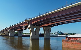
The I-35W Saint Anthony Falls Bridge crosses the Mississippi River one-half mile downstream from the Saint Anthony Falls in Minneapolis, Minnesota in the U.S., carrying north–south traffic on Interstate 35W. The ten-lane bridge replaced the I-35W Mississippi River bridge, which collapsed on August 1, 2007. It was planned and is maintained by the Minnesota Department of Transportation (MnDOT). The planning, design, and construction processes were completed more quickly than normal because Interstate 35W is a critical artery for commuters and truck freight. The bridge opened September 18, 2008, well ahead of the original goal of December 24.

U.S. Highway 169 (U.S. 169) is a major north–south highway in the U.S. state of Minnesota, connecting the Minnesota River valley with the Twin Cities and the Iron Range. Much of the route is built to expressway or freeway standards.
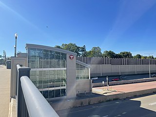
I-35W & 46th Street station is a Metro Orange Line bus rapid transit station located in Minneapolis, Minnesota. In addition to the BRT service, the station is also served by Metro route 578. The station was constructed as part of the I-35W/Minnesota State Highway 62 Crosstown Commons reconstruction project and opened in 2010. Consisting of two levels, one on East 46th Street, and the other in the median of Interstate 35W, the station was the first of its kind in Minnesota. The station allows for transit routes operating on I-35W to stop for riders without leaving the region's high occupancy toll lane system. The station was designed in anticipation of full bus rapid transit service along I-35W to downtown Minneapolis, a vision that was realized in 2021 with the opening of the Metro Orange Line. The station cost $4.5 million to build.
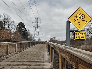
Nine Mile Creek Regional Trail is a 15.3-mile (24.6 km) mixed-use path in Hennepin County, Minnesota, United States. It is maintained by the Three Rivers Park District. The trail features 8 separate boardwalks in 1.7 miles (2.7 km) that traverse Nine Mile Creek and its marshes. It is predicted to serve 400,000 people yearly.

