I. B. Perrine

Last updated
I. B. Perrine

Ibperrinestatue.JPG

Statue of Perrine in Twin Falls, Idaho
Born(1861-05-07)May 7, 1861
Delaware, Indiana
Died October 2, 1943(1943-10-02) (aged 82)
Twin Falls, Idaho
Resting place Jerome, Idaho
Residence Jerome, Idaho
Nationality American
Occupation Farmer, rancher, businessman
Known for Credited as the founder
of Twin Falls and other cities in the Magic Valley region of Idaho
Spouse(s) Hortense McKay Perrine
(1873–1947)
Children 1 daughter, 2 sons
Parent(s) George W. Perrine
Sarah A. (Burton) Perrine

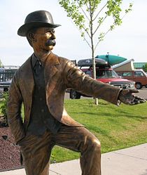
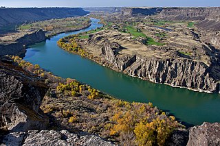
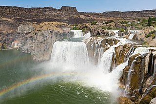
Ira Burton Perrine (May 7, 1861 - October 2, 1943) was an Idaho farmer, rancher and businessman. Perrine is generally credited as the founder of Twin Falls and other towns in the Magic Valley region.

Idaho State of the United States of America

Idaho is a state in the northwestern region of the United States. It borders the state of Montana to the east and northeast, Wyoming to the east, Nevada and Utah to the south, and Washington and Oregon to the west. To the north, it shares a small portion of the Canadian border with the province of British Columbia. With a population of approximately 1.7 million and an area of 83,569 square miles (216,440 km2), Idaho is the 14th largest, the 12th least populous and the 7th least densely populated of the 50 U.S. states. The state's capital and largest city is Boise.

Twin Falls, Idaho City in Idaho, United States

Twin Falls is the county seat and largest city of Twin Falls County, Idaho, United States. The city had a population of 44,125 as of the 2010 census.

Magic Valley Region in Idaho, United States

The Magic Valley is a region in south-central Idaho constituting Blaine, Camas, Cassia, Gooding, Jerome, Lincoln, Minidoka, and Twin Falls counties. It is particularly associated with the agricultural region in the Snake River Plain located in the area. The northern Magic Valley region — particularly Blaine and Camas Counties — is also known as the Wood River Valley after the Big Wood River.

Contents

Born in Delaware, Indiana, Perrine's parents were George and Sarah Burton Perrine, and he was a descendant of Daniel Perrin, "The Huguenot."[ citation needed ]

Delaware, Indiana Unincorporated community in Indiana, United States

Delaware is an unincorporated community in Delaware Township, Ripley County, in the U.S. state of Indiana.

Daniel Perrin American settler

Daniel Perrin (1642–1719) was one of the first permanent European inhabitants of Staten Island, New York. Known as "The Huguenot", he arrived in New York Harbor from the Isle of Jersey on July 29, 1665 aboard the ship Philip, under the command of Philip Carteret. He lived in Elizabethtown, part of the Elizabethtown Tract, for a while before moving across the Arthur Kill and settling on Staten Island. In 1692 he was granted 80 acres (320,000 m2) of land by Governor Benjamin Fletcher in an area along the south shore of Staten Island then known as Smoking Point. During the American Revolutionary War this area was known as Blazing Star, and is now known as Rossville.

Idaho

Perrine moved to Idaho Territory in 1884 and established a farm and ranch operation in the Snake River Canyon near present-day Jerome.

Idaho Territory territory of the USA between 1863–1890

The Territory of Idaho was an organized incorporated territory of the United States that existed from March 3, 1863, until July 3, 1890, when the final extent of the territory was admitted to the Union as Idaho.

Snake River Canyon (Idaho) large canyon formed by the Snake River in the Magic Valley region of southern Idaho

Snake River Canyon is a large canyon formed by the Snake River in the Magic Valley region of southern Idaho, forming part of the boundary between Twin Falls County to the south and Jerome County to the north.

Jerome, Idaho City in Idaho, United States

Jerome is a city in and county seat of Jerome County, Idaho, United States. The population was 10,890 at the 2010 census, up from 7,780 in 2000. The city is the county seat of Jerome County, and is part of the Twin Falls Micropolitan Statistical Area. It is the second largest city in Idaho’s Magic Valley region, second only to Twin Falls which is located 10 miles southeast. Jerome's economy is largely agrarian with dairy farming being one of the main driving forces of the economy.

He was a successful farmer and rancher who among other things received a gold medal for his fruit display at the 1904 Louisiana Purchase Exposition in St. Louis. The ranch remained in the Perrine family until 1964, when it was sold and became part of Blue Lakes Country Club. [1]

Louisiana Purchase Exposition

The Louisiana Purchase Exposition, informally known as the St. Louis World's Fair, was an international exposition held in St. Louis, Missouri, United States, from April 30 to December 1, 1904. Local, state, and federal funds totaling $15 million were used to finance the event. More than 60 countries and 43 of the 45 American states maintained exhibition spaces at the fair, which was attended by nearly 19.7 million people.

Although Perrine's operation in the canyon received plenty of water, the surrounding area could not be easily irrigated and was therefore largely unproductive. Beginning in 1893, Perrine worked to convince private financiers to build a dam on the Snake River, along with a corresponding canal system to irrigate the area. This work culminated in the 1900 founding of the Twin Falls Land and Water Company and the subsequent completion of Milner Dam in 1905. [2] [3]

Milner Dam

Milner Dam is a rockfill dam near Burley in south central Idaho. It impounds the Snake River in a reservoir named Milner Lake. The dam spans the river across two islands, with three embankments.

After Twin Falls was founded in 1904, Perrine served as a bank president and owned a hotel in the new city.

Legacy

Perrine Bridge over Snake River Canyon Perrine Bridge Twin Falls2.jpg
Perrine Bridge over Snake River Canyon

Perrine died at age 82 in 1943 and is buried at the family cemetery near his former ranch in Jerome County.

Jerome County, Idaho County in the United States

Jerome County is a county in the U.S. state of Idaho. As of the 2010 Census the county had a population of 22,374. The county seat and largest city is Jerome. The county was created by the Idaho Legislature on February 8, 1919, by a partition of Lincoln County. It was named after either Jerome Hill, a developer of the North Side Irrigation Project, his son-in-law Jerome Kuhn, or his grandson Jerome Kuhn, Jr.

The Perrine Bridge, carrying U.S. 93 over the Snake River Canyon, is named for him, and a statue of him is outside the city's visitor center. Also named for him are an elementary school in Twin Falls and Perrine Coulee, which runs through the city and ends as a waterfall on the south rim of the canyon, west of the bridge.

Video

Related Research Articles

Boise River river in the United States of America

The Boise River is a 102-mile-long (164 km) tributary of the Snake River in the northwestern United States. It drains a rugged portion of the Sawtooth Range in southwestern Idaho northeast of Boise, as well as part of the western Snake River Plain. The watershed encompasses approximately 4,100 square miles (11,000 km2) of highly diverse habitats, including alpine canyons, forest, rangeland, agricultural lands, and urban areas.

Interstate 84 (Oregon–Utah) Interstate Highway in the U.S. states of Oregon, Idaho, and Utah

Interstate 84 (I-84) is an Interstate Highway in the northwestern United States. The highway runs from Portland, Oregon, to a junction with I-80 near Echo, Utah. The sections running through Oregon and Idaho are also known as the Vietnam Veterans Memorial Highway. The highway originally served as a fork of I-80 to serve the Pacific Northwest, and was originally numbered Interstate 80N.

Shoshone Falls waterfall

Shoshone Falls is a waterfall on the Snake River in southern Idaho, United States, approximately 3 miles (4.8 km) northeast of the city of Twin Falls. Sometimes called the "Niagara of the West," Shoshone Falls is 212 feet (65 m) high—45 feet (14 m) higher than Niagara Falls—and flows over a rim nearly 1,000 feet (300 m) wide.

Perrine Bridge

The I. B. Perrine Bridge is four-lane truss arch span in the western United States. Located at Twin Falls, Idaho, it carries U.S. Highway 93 over the Snake River Canyon, connecting to Jerome County and Interstate 84.

American Falls Dam architectural structure

The American Falls Dam is a concrete gravity-type dam located near the town of American Falls, Idaho, on river mile 714.7 of the Snake River. The dam and reservoir are a part of the Minidoka Project on the Snake River Plain and are used primarily for flood control, irrigation, and recreation. When the original dam was built by the Bureau of Reclamation, the residents of American Falls were forced to relocate three-quarters of their town to make room for the reservoir. A second dam was completed in 1978 and the original structure was demolished. Although the dam itself is located in Power County, its reservoir also stretches northeastward into both Bingham County and Bannock County.

National Register of Historic Places listings in Idaho Wikimedia list article

This is a directory of properties and districts included among the National Register of Historic Places listings in Idaho. There are approximately 1,000 sites in Idaho listed on the National Register. Each of the state's 44 counties has at least one listing on the National Register.

U.S. Route 93 in Idaho highway in Idaho

U.S. Route 93 is a north–south U.S. Highway in the U.S. state of Idaho.

Moyie River Canyon Bridge bridge in United States of America

The Moyie River Canyon Bridge is a structural steel truss cantilever bridge that spans the Moyie River in the city of Moyie Springs just east of Bonners Ferry, Idaho. Constructed in 1965, the bridge is on U.S. Route 2 at mile marker 70. The bridge is 1,223 ft (373 m) long and 464 ft (141 m) high, and is a replacement for an obsolete 1923 bridge built downstream from Moyie Dam.

Idaho Power

Idaho Power Company (IPC) is a regulated electrical power utility. Its business involves the purchase, sale, generation, transmission and distribution of electricity in eastern Oregon and southern Idaho. It is a subsidiary of IDACORP, Inc. The company's 24,000-square-mile (62,000 km2) service area generally follows the area around the Snake River and its tributaries.

Salmon Falls Creek river in the United States of America

Salmon Falls Creek is a tributary of the Snake River, flowing from northern Nevada into Idaho in the United States. Formed in high mountains at the northern edge of the Great Basin, Salmon Falls Creek flows northwards 121 miles (195 km), draining an arid and mountainous basin of 2,103 square miles (5,450 km2). The Salmon Falls Creek valley served as a trade route between the Native American groups of the Snake River Plain and Great Basin. Today, most of its water is used for irrigation.

The Snake River Aquifer is a large reservoir of groundwater underlying the Snake River Plain in the southern part of the U.S. state of Idaho. Most of the water in the aquifer comes from rain and melting snow that flows onto the plain from the Snake River, Big Lost River, Bruneau River, and other watercourses of southern Idaho. Measuring about 400 miles (640 km) from east to west, it is an important water source for agricultural irrigation in the Plain. The Snake River Aquifer is commonly defined as two separate parts, separated by Salmon Falls Creek: the Eastern Snake River Plain Aquifer and Western Snake River Plain Aquifer.

Twin Falls (Idaho) waterfall on the Snake River in Idaho, USA

Twin Falls is a waterfall on the Snake River in the Snake River Canyon in southern Idaho, United States. The falls are located on the border of Jerome and Twin Falls counties, a few miles east of its namesake city, Twin Falls. They are upstream of Pillar Falls and Shoshone Falls and just downstream from Milner Dam.

The Hansen Bridge is a 350-foot (110 m) high concrete deck girder bridge that carries Idaho State Highway 50 over the Snake River Canyon near Twin Falls, Idaho. The bridge spans the border of Jerome and Twin Falls Counties.

References

  1. Blue Lakes Country Club - History
  2. "Milner Dam, #497" (PDF). Idaho State Historical Society. (Reference Series). 1985. Retrieved April 25, 2016.
  3. Smith, Paul. "The History of Twin Falls". City of Twin Falls (Idaho). Retrieved April 25, 2016.