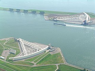
The Nieuwe Waterweg is a ship canal in the Netherlands from het Scheur west of the town of Maassluis to the North Sea at Hook of Holland: the Maasmond, where the Nieuwe Waterweg connects to the Maasgeul. It is the artificial mouth of the river Rhine.

IJmuiden is a port city in the Dutch province of North Holland. It is the main town in the municipality of Velsen which lies mainly to the south-east. Including its large sea locks, it straddles the mouth of the North Sea Canal to Amsterdam. To the south it abuts a large reserve of plant-covered dunes, the Zuid-Kennemerland National Park. The city is on the south bank; the north bank is otherwise a steel plant and Velsen-Noord.
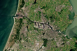
The North Sea Canal is a Dutch ship canal from Amsterdam to the North Sea at IJmuiden, constructed between 1865 and 1876 to enable seafaring vessels to reach the port of Amsterdam. This man-made channel terminates at Amsterdam in the closed-off IJ Bay, which in turn connects to the Amsterdam-Rhine Canal.

Poole Harbour is a large natural harbour in Dorset, southern England, with the town of Poole on its shores. The harbour is a drowned valley (ria) formed at the end of the last ice age and is the estuary of several rivers, the largest being the Frome. The harbour has a long history of human settlement stretching to pre-Roman times. The harbour is extremely shallow, with one main dredged channel through the harbour, from the mouth to Holes Bay.

Europoort is an area of the Port of Rotterdam and the adjoining industrial area in the Netherlands. Being situated at Southside of the mouth of the rivers Rhine and Meuse with the hinterland consisting of the Netherlands, Germany, Belgium and partly France, Europoort is one of the world's busiest ports and considered a major entry to Europe. The port handled 12 million containers in 2015.

Panamax and New Panamax are terms for the size limits for ships travelling through the Panama Canal. The limits and requirements are published by the Panama Canal Authority (ACP) in a publication titled "Vessel Requirements". These requirements also describe topics like exceptional dry seasonal limits, propulsion, communications, and detailed ship design.
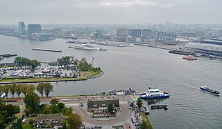
The IJ is a body of water, formerly a bay, in the Dutch province of North Holland. It is known for being Amsterdam's waterfront.

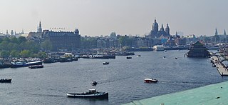
SAIL Amsterdam is a quinquennial maritime event in Amsterdam in the Netherlands. Tall ships from all over the world visit the city to moor in its eastern harbour. The 2020 event was cancelled due to the COVID-19 pandemic.

Cochin Port or Kochi Port is a major port on the Arabian Sea – Laccadive Sea – Indian Ocean sea-route in the city of Kochi and is one of the largest ports in India. It is also the first transshipment port in India. The port lies on two islands in the Lake of Kochi: Willingdon Island and Vallarpadam, towards the Fort Kochi river mouth opening onto the Laccadive Sea. The International Container Transshipment Terminal (ICTT), part of the Cochin Port, is the largest container transshipment facility in India.
Thames Europort is a roll-on/roll-off port facility at Stone in Kent, England, close to Dartford. The facility is situated on the southern side of the River Thames. The port was used solely for freight traffic, both trailer and container based but now mainly handles imports of Mercedes cars and vans. There is a large pontoon-type berth which can accommodate two ships for simultaneous loading and discharging. The terminal can accommodate vessels up to 236 metres (774 ft) in length, 32.2 metres (106 ft) beam and 11.5 metres (38 ft) draft.

Sailing Directions are written directions that describe the routes to be taken by boats and ships during coastal navigation and port approaches. There are also products known as Sailing Directions, which are books written by various Hydrographic Offices throughout the world. They are known as Pilot Books, because they provide local knowledge of routes and landmarks, which would typically be provided by a local marine pilot. As such, they are used frequently by naval and government vessels, who are exempted from 'Compulsory Pilotage' in many ports.

Pana Tinani is an island in the Louisiade Archipelago in Milne Bay Province, Papua New Guinea.

The Port of Albany is located within Princess Royal Harbour in King George Sound on the south coast of Western Australia, in the Great Southern region.
The port of Amsterdam is a seaport in Amsterdam in North Holland, Netherlands. It is the 4th busiest port in Europe by metric tonnes of cargo. The port is located on the bank of a former bay named the IJ and the North Sea Canal, with which it is connected to the North Sea. The port was first used in the 13th century and was one of the main ports of the Dutch East India Company in the 17th century. Today, the port of Amsterdam is the second largest port in the Netherlands, the largest being the Port of Rotterdam. In 2014, the port of Amsterdam had a cargo throughput of 97.4 million tons, most of which was bulk cargo.

The J.C.J. van Speijk Lighthouse is a lighthouse on the North Sea coast near Egmond aan Zee, in the municipality of Bergen, North Holland, in the Netherlands. The foundation of the lighthouse, shaped like a tomb, is the official Dutch memorial to Jan van Speyk, a hero to the Dutch people.
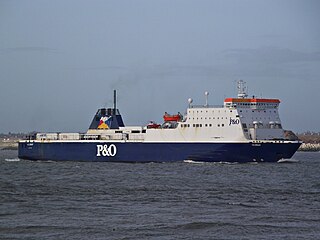
MS Norbay is a ro-pax vessel owned and operated by the British ferry company P&O Ferries. She was built by Van Der Giessen-de Noord N.V., Netherlands in 1994.
The Eurogeul or Euromaasgeul is a channel dug in the North Sea in conjunction with the Port of Rotterdam. It has a length of 57 km and a depth of 23 meters.
Germein Bay is a bay in the Australian state of South Australia located at the northern end Spencer Gulf on the gulf's east coast to the immediate north of the city of Port Pirie. Its extent includes the port known as ‘Port Pirie’ and the former port of Port Germein. Since 2012, the majority of the bay has been within the protected area known as the Upper Spencer Gulf Marine Park.

Tanjung Bara Coal Terminal, abbreviated as TBCT, or commonly known as Tanjung Bara, is a coal loading port in Indonesia. Primarily known for its coal loading terminal, it lies on the southeast coast of East Kalimantan, Borneo.
The Oosterdok is a former wet dock in Amsterdam. It was created in 1831-1832 by constructing the Oosterdoksdam and the Oosterdoksluis, forming a reliable deep port closed off from the tidal IJ.
