An intelligent transportation system (ITS) is an advanced application that aims to provide innovative services relating to different modes of transport and traffic management and enable users to be better informed and make safer, more coordinated, and 'smarter' use of transport networks.

A ramp meter, ramp signal, or metering light is a device, usually a basic traffic light or a two-section signal light together with a signal controller, that regulates the flow of traffic entering freeways according to current traffic conditions. Ramp meters are used at freeway on-ramps to manage the rate of automobiles entering the freeway. Ramp metering systems have proved to be successful in decreasing traffic congestion and improving driver safety.

A variable-message sign or message board, often abbreviated VMS, VMB, CMS, or DMS, and in the UK known as a matrix sign, is an electronic traffic sign often used on roadways to give travelers information about special events. Such signs warn of traffic congestion, accidents, incidents such as terrorist attacks, AMBER/Silver/Blue Alerts, roadwork zones, or speed limits on a specific highway segment. In urban areas, VMS are used within parking guidance and information systems to guide drivers to available car parking spaces. They may also ask vehicles to take alternative routes, limit travel speed, warn of duration and location of the incidents, inform of the traffic conditions, or display general public safety messages.
Network congestion in data networking and queueing theory is the reduced quality of service that occurs when a network node or link is carrying more data than it can handle. Typical effects include queueing delay, packet loss or the blocking of new connections. A consequence of congestion is that an incremental increase in offered load leads either only to a small increase or even a decrease in network throughput.
Floating car data (FCD) in traffic engineering and management is typically timestamped geo-localization and speed data directly collected by moving vehicles, in contrast to traditional traffic data collected at a fixed location by a stationary device or observer. In a physical interpretation context, FCD provides a Lagrangian description of the vehicle movements whereas stationary devices provide an Eulerian description. The participating vehicle acts itself consequently as a moving sensor using an onboard GPS receiver or cellular phone. The most common and widespread use of FCD is to determine the traffic speed on the road network. Based on these data, traffic congestion can be identified, travel times can be calculated, and traffic reports can be rapidly generated. In contrast to stationary devices such as traffic cameras, number plate recognition systems, and induction loops embedded in the roadway, no additional hardware on the road network is necessary.
In computer networks, a tunneling protocol is a communication protocol which allows for the movement of data from one network to another. They can, for example, allow private network communications to be sent across a public network, or for one network protocol to be carried over an incompatible network, through a process called encapsulation.

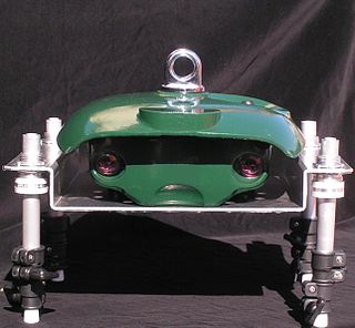
The Infra-Red Traffic Logger, more commonly known simply by the acronym TIRTL, is a multi-purpose traffic sensor that can be used as a traffic counter, speed sensor, red light camera sensor, heavy vehicle tracker, overheight vehicle sensor, rail crossing sensor and network management system. The initial development of the device started in 1997 in conjunction with the New South Wales Roads & Traffic Authority and started commercial domestic and international sales in 2002. It is currently in use in sixteen countries.

Interstate 35E (I-35E) is an Interstate Highway in the US state of Minnesota, passing through downtown Saint Paul. It is one of two through routes for I-35 through the Twin Cities of Minneapolis and Saint Paul, the other being I-35W through Minneapolis. Thus, both ends of I-35E are shared with I-35W and I-35.

The Ohio Department of Transportation is the administrative department of the Ohio state government responsible for developing and maintaining all state and U.S. roadways outside of municipalities and all Interstates except the Ohio Turnpike. In addition to highways, the department also helps develop public transportation and public aviation programs. ODOT is headquartered in Columbus, Ohio. Formerly, under the direction of Michael Massa, ODOT initiated a series of interstate-based Travel Information Centers, which were later transferred to local partners. The Director of Transportation is part of the Governor's Cabinet.
STREAMS Integrated Intelligent Transport System is an enterprise traffic management system designed to operate in the Microsoft Windows environment. Like most traffic management systems, STREAMS is an array of institutional, human, hardware, and software components designed to monitor, control, and manage traffic on streets and highways. Advanced traffic management systems come under the banner of ITS. ITS is the application of information and communications technology to transport operations in order to "reduce operating costs", "improve safety" and "maximize the capacity of existing infrastructure". STREAMS provides traffic signal management, incident management, motorway management, vehicle priority, traveler information, flood monitoring and parking guidance within a single integrated system is what the product says. STREAMS is developed by Transmax.
In computing, Microsoft's Windows Vista and Windows Server 2008 introduced in 2007/2008 a new networking stack named Next Generation TCP/IP stack, to improve on the previous stack in several ways. The stack includes native implementation of IPv6, as well as a complete overhaul of IPv4. The new TCP/IP stack uses a new method to store configuration settings that enables more dynamic control and does not require a computer restart after a change in settings. The new stack, implemented as a dual-stack model, depends on a strong host-model and features an infrastructure to enable more modular components that one can dynamically insert and remove.

Parking guidance and information (PGI) systems, or car park guidance systems, present drivers with dynamic information on parking within controlled areas. The systems combine traffic monitoring, communication, processing and variable message sign technologies to provide the service.
Georgia Navigator is an Advanced Traffic Management System used in the U.S. state of Georgia. It is operated by the Georgia Department of Transportation (GDOT), and was first activated in April 1996, just before the 1996 Summer Olympics in Atlanta.
The National Transportation Communications for Intelligent Transportation System Protocol (NTCIP) is a family of standards designed to achieve interoperability and interchangeability between computers and electronic traffic control equipment from different manufacturers.

Active traffic management is a method of increasing peak capacity and smoothing traffic flows on busy major highways. Techniques include variable speed limits, hard-shoulder running and ramp-metering controlled by overhead variable message signs. It has been implemented in several countries, including Germany, the United Kingdom, Canada and the United States.
The advanced traffic management system (ATMS) field is a primary subfield within the intelligent transportation system (ITS) domain, and is used in the United States. The ATMS view is a top-down management perspective that integrates technology primarily to improve the flow of vehicle traffic and improve safety. Real-time traffic data from cameras, speed sensors, etc. flows into a transportation management center (TMC) where it is integrated and processed, and may result in actions taken with the goal of improving traffic flow. The National ITS Architecture defines the following primary goals and metrics for ITS:
Traffic optimization is the methods by which time stopped in road traffic is reduced.
VRPN is a device-independent, network-based interface for accessing virtual reality peripherals in VR applications. It was originally designed and implemented by Russell M. Taylor II at the Department of Computer Science of the University of North Carolina at Chapel Hill. VRPN was maintained and supported by Sensics while it was business. It is currently maintained by ReliaSolve and developed in collaboration with a productive community of contributors. It is described more fully at vrpn.net and in VRPN-VRST.
QUIC is a general-purpose transport layer network protocol initially designed by Jim Roskind at Google. It was first implemented and deployed in 2012 and was publicly announced in 2013 as experimentation broadened. It was also described at an IETF meeting. The Chrome web browser, Microsoft Edge, Firefox, and Safari all support it. In Chrome, QUIC is used by more than half of all connections to Google's servers.

The Fast Adaptive and Secure Protocol (FASP) is a proprietary data transfer protocol. FASP is a network-optimized network protocol created by Michelle C. Munson and Serban Simu, productized by Aspera, and now owned by IBM subsequent to its acquisition of Aspera. The associated client/server software packages are also commonly called Aspera. The technology is patented under US Patent #8085781, Bulk Data Transfer, #20090063698, Method and system for aggregate bandwidth control. and others.


