Active traffic management

Last updated

The gantries over the M42 motorway in the United Kingdom show the variable speed limit in operation. M42 A45 junction 10y07.JPG
The gantries over the M42 motorway in the United Kingdom show the variable speed limit in operation.

Active traffic management (also managed lanes, smart lanes, managed/smart motorways) is a method of increasing peak capacity and smoothing traffic flows on busy major highways. Techniques include variable speed limits, hard-shoulder running and ramp-metering controlled by overhead variable message signs. It has been implemented in several countries, including Germany, the United Kingdom, Canada and the United States.

Contents

United Kingdom

It is currently in operation on the M42 motorway south-east of Birmingham and in Warwickshire. The scheme had initially been criticised by some due to possible safety and environmental concerns, however a Highways Agency report into the first six months of the scheme showed a reduction in the number of accidents from over 5 a month to 1.5 per month on average. [1] [2] it has now been expanded onto other roads following the initial evaluation on the M42. It is seen as a less expensive alternative to road widening.

Technology

The section of road subject to ATM is monitored by MIDAS sensor loops [3] placed in the road every 100 metres (328 ft) [4] (which is closer than normal) [5] to observe traffic flows. [4] A computerised system monitors the traffic flows and can set the best speed limit for the current flow of traffic and switch on speed limit signs mounted on gantries [6] up to 2 kilometres (1.24 mi) before an incident. [7] Operators can also monitor 150 [8] CCTV cameras [9] along the route and can control both the speed limits and information signs. [6] Overhead variable message signs can direct drivers to use the hard shoulder during busy periods. [9]

When the speed limit has been lowered to 50 miles per hour (80 km/h) or below the hard shoulder can be opened as an additional lane. [10] To facilitate this and still maintain safety [5] a series of refuge areas have been created around every 500 metres (1,640 ft) along that stretch of the road. [2] These take the form of lay bys to the side of the hard shoulder and contain SOS phones within them. [11] In the event of a vehicle breaking down on the hard shoulder, operators can close it, or they can close a lane to allow emergency services access to an accident. [9] The hard shoulder is never opened on the sections under a junction between the off and on slip roads. Close to junctions use of the hard shoulder as a lane is restricted to traffic exiting or entering at that junction. [12]

ATM involves converting the hard shoulder into a normal lane during periods of high traffic flow to expand the capacity of the road [13] and may reduce the need to widen motorways. [13] Similar schemes have already been implemented in Europe. [8]

The system makes use of Automatic Number Plate Recognition cameras which to monitor traffic flows and tailor the system. [14] Digital enforcement cameras are also mounted on the gantries and are operated by the West Midlands Police to enforce the mandatory variable speed limits. [14]

Future implementation

In Canada

While active traffic management is currently limited in Canada, more implementation is expected to occur in the future. The QEW highway near Toronto utilizes ramp metering for a portion of the roadway on-ramps.

The city of Toronto has also implemented traffic signal re-timing (signal optimization). Approximately 22 intersections in Toronto now have adaptive signals.

In the province of British Columbia, variable speed limits on overhead gantries have been in use since 2019 on a few highways.

In the United States

A number of highways in the United States have variable message signs and variable speed limits. The New Jersey Turnpike has been using active signage since the 1960s, though systems have evolved over time as they have been deployed in other areas of the country. A modern implementation of active traffic management was activated in 2010 using IRIS on Interstate 35Win Minneapolis, Minnesota and its southern suburbs as part of the Urban Partnership Agreement. Active lane management on I-35W was later combined with high-occupancy toll lanes and eventually joined by a bus rapid transitway. [15] [16] An ATM scheme was deployed on 10 August 2010 in Washington. [17]

In Washington State

The Washington State Department of Transportation (WSDOT) has completed Active Traffic Management schemes on several motorways in the Seattle metropolitan area. It is the first legally enforceable system in the United States. Failure to comply with speed limits and overhead instructions are citable offences.

ATM systems were activated on 11.6 km (7.2 mi) of the I-5 northbound carriageway in August 2010. [18] In November 2010, ATM was expanded to 12.4 km (7.7 mi) of the SR 520 in both directions. In March 2011, ATM completed testing and began operations on 14.3 km (8.9 mi) of the I-90 in both directions.

The ATM schemes build upon WSDOT's existing arsenal of Intelligent Transport Systems (ITS) which is supported by traffic sensor loops embedded in the pavement approximately every 800 m (2640 ft) apart. On motorway sections with ATM, gantries are also spaced roughly 800 m (2640 ft) apart. The primary ATM strategies used by WSDOT is ramp metering, queue protection, hard shoulder running, junction control, and lane-specific signalling. Motorway operations in the Seattle area are conducted in the Northwest Region Traffic Management Centre in Shoreline, just north of Seattle.

Ramp metering

WSDOT's ramp metering strategy is aimed at reducing the volume of traffic entering the motorway and has been in operation since the early 1980s. Traffic signals are operated part-time on slip roads, which are used to temporarily store traffic. The queuing traffic is then released onto the motorway one vehicle per signal cycle.

Unlike other states in the U.S., WSDOT does not have a time-of-day schedule for metering, nor does it have a rigid meter rate as it is considered too inflexible. Dedicated operators monitor traffic conditions visually through CCTV and switch the meters on and off manually. Once turned on, the meter rate is automatically determined and updated every 20 seconds using a local traffic-responsive algorithm based on fuzzy logic. The algorithm, named the Fuzzy Logic Ramp Metering algorithm, is the successor to the Bottleneck Algorithm.

The length of the queue on the slip road and the mainline occupancy immediately surrounding the slip road are fed as inputs to the algorithm, which determines a meter rate that allows as few vehicles to join the motorway mainline as possible without overflowing queuing vehicles onto nearby arterial streets. During its operation, ramp metering is fully automated. Operators will manually tune the ramp meters if necessary. They also have the ability to intervene when a malfunction occurs.

The performance of Fuzzy Logic Ramp Metering is comparable to the ALINEA algorithm used by several European agencies.

Queue protection

Variable speed limits displayed on overhead lane control signs (LCS) above each lane are used to reduce traffic speed prior to a congestion point. Variable message signs (VMS) accompany the reduced speed limit to warn drivers of slow traffic. Speeds are determined automatically and are lowered using one or two upstream gantries depending on the size of the reduction. Intervals of 8.0 km/h (5.0 mph) and 16.1 km/h (10.0 mph) are common. Upon the end of a congestion point, speed limits are returned to the default speed. The primary purpose of queue protection is to reduce rear-end collisions. [19]

Hard shoulder running and junction control

As part of the SR 520 Bridge Replacement and HOV scheme, WSDOT plans to implement junction control through hard shoulder running. Based on traffic conditions, ATM will open the shoulder as an auxiliary lane on the SR 520 westbound carriageway across Portage Bay Bridge, which will turn the motorway section from a 3 + 2 to a 3 + 3 dual carriageway. The additional capacity will allow traffic from the Montlake Boulevard junction more room to merge. The shoulder running can also be activated for incident management. A similar scheme is being developed for the I-5 northbound carriageway in Marysville. [19]

Lane specific signalling

In the event of a lane closure due to a collision or roadwork, LCS signs will display a red X above the closed lane at the location of the incident. The gantry immediately upstream will direct motorists to merge into adjacent lanes. Drivers are allowed approximately 800 m (2640 ft), or one gantry interval, to clear the lane. Lane closures are done manually through operator intervention. Operators also have the ability to override HOV designation above HOV lanes, opening it to regular traffic if necessary. [19]

Implications

Although WSDOT has not published data on the performance of the ATM implementation, low compliance with variable speed limits and overhead instructions is noticeable among Washington drivers. Part of the challenge is allowing drivers more time to adapt to the system, while the other part is poor enforcement from the Washington State Patrol and the absence of automated enforcement such as those used in England.

See also

Related Research Articles

<span class="mw-page-title-main">Ramp meter</span> Traffic management system

A ramp meter, ramp signal, or metering light is a device, usually a basic traffic light or a two-section signal light together with a signal controller, that regulates the flow of traffic entering freeways according to current traffic conditions. Ramp meters are used at freeway on-ramps to manage the rate of automobiles entering the freeway. Ramp metering systems have proved to be successful in decreasing traffic congestion and improving driver safety.

<span class="mw-page-title-main">M1 motorway</span> First major motorway in England

The M1 motorway connects London to Leeds, where it joins the A1(M) near Aberford, to connect to Newcastle. It was the first inter-urban motorway to be completed in the UK; the first motorway in the country was the Preston Bypass, which later became part of the M6.

<span class="mw-page-title-main">M27 motorway</span> Motorway in Hampshire, England

The M27 is a motorway in Hampshire, England. It is 27.9 miles (44.9 km) long and runs between Cadnam and Portsmouth. It was opened in stages between 1975 and 1983, providing the largest two urban areas in Hampshire with a direct motorway link. An extension into the county of West Sussex was planned but never constructed. A number of smaller motorways were proposed, connecting the city centres of Southampton and Portsmouth to the motorway; of these only the M271 and M275 were built. Three sections of the M27 have since been widened to four lanes each way, the first between junctions 7 and 8, the second between junctions 3 and 4, and the third begins at the slip road where junction 11 joins until mid-way to junction 12.

<span class="mw-page-title-main">M42 motorway</span> Motorway in England

The M42 motorway runs north east from Bromsgrove in Worcestershire to just south west of Ashby-de-la-Zouch in Leicestershire, passing Redditch, Solihull, the National Exhibition Centre (NEC) and Tamworth on the way, serving the east of the Birmingham metropolitan area. The section between the M40 and junction 4 of the M6 forms – though unsigned as such – a part of Euroroute E05. Northwards beyond junction 11, the route is continued as the A42; the junctions on this section, 12–14, are numbered like a continuation of the motorway, but the road has non-motorway status from here.

<span class="mw-page-title-main">Variable-message sign</span> Electronic traffic sign with changeable messages

A variable-message sign or message board, often abbreviated VMS, VMB, CMS, or DMS, and in the UK known as a matrix sign, is an electronic traffic sign often used on roadways to give travelers information about special events. Such signs warn of traffic congestion, accidents, incidents such as terrorist attacks, AMBER/Silver/Blue Alerts, roadwork zones, or speed limits on a specific highway segment. In urban areas, VMS are used within parking guidance and information systems to guide drivers to available car parking spaces. They may also ask vehicles to take alternative routes, limit travel speed, warn of duration and location of the incidents, inform of the traffic conditions, or display general public safety messages.

<span class="mw-page-title-main">Shoulder (road)</span> Reserve lane by the verge of a roadway

A shoulder, hard shoulder (British) or breakdown lane is an emergency stopping lane by the verge of a road or motorway, on the right side in countries which drive on the right, and on the left side in countries which drive on the left. Many wider (U.S.) freeways, or expressways elsewhere have shoulders on both sides of each directional carriageway — in the median, as well as at the outer edges of the road, for additional safety. Shoulders are not intended for use by through traffic, although there are exceptions.

<span class="mw-page-title-main">Dual carriageway</span> Type of road

A dual carriageway (BrE) or a divided highway (AmE) is a class of highway with carriageways for traffic travelling in opposite directions separated by a central reservation (BrE) or median (AmE). Roads with two or more carriageways which are designed to higher standards with controlled access are generally classed as motorways, freeways, etc., rather than dual carriageways.

<span class="mw-page-title-main">M275 motorway</span> Motorway in Hampshire, southern England

The M275 is a 2-mile (3.2 km) long, dual three-lane motorway in Hampshire, southern England. It is the principal road route for entering and leaving Portsmouth. It continues as the A3 into Portsmouth, and meets the M27 at its northern terminus. From the motorway, there are scenic views over Portsmouth harbour, and the Sails of the South between the two carriageways.

<span class="mw-page-title-main">Road hierarchy</span> Hierarchy in road traffic

The road hierarchy categorizes roads according to their functions and capacities. While sources differ on the exact nomenclature, the basic hierarchy comprises freeways, arterials, collectors, and local roads. Generally, the functional hierarchy can more or less correspond to the hierarchy of roads by their owner or administrator.

<span class="mw-page-title-main">Limited-access road</span> High-speed road with many characteristics of a controlled-access highway (freeway or motorway)

A limited-access road, known by various terms worldwide, including limited-access highway, dual-carriageway, expressway, and partial controlled-access highway, is a highway or arterial road for high-speed traffic which has many or most characteristics of a controlled-access highway, including limited or no access to adjacent property, some degree of separation of opposing traffic flow, use of grade separated interchanges to some extent, prohibition of slow modes of transport, such as bicycles, (draught) horses, or self-propelled agricultural machines; and very few or no intersecting cross-streets or level crossings. The degree of isolation from local traffic allowed varies between countries and regions. The precise definition of these terms varies by jurisdiction.

<span class="mw-page-title-main">Road signs in Ireland</span> Overview of road signs in Ireland

Road signs in the Republic of Ireland do not differ greatly from those used elsewhere in Europe – with the notable exception that hazard or warning signs follow the "New World" style of a yellow diamond. The symbols used on these warning signs do, nevertheless, resemble much more closely those used in the rest of Europe than many of those seen in the United States.

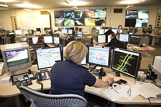
Motorway Incident Detection and Automatic Signalling, usually abbreviated to MIDAS, is a UK distributed network of traffic sensors, mainly inductive loops, which are designed to alert the local regional control centre (RCC) to traffic flow and average speeds, and set variable message signs and advisory speed limits with little human intervention. Companies such as RAC, TomTom and Google use this traffic flow data via halogens reporting systems.

<span class="mw-page-title-main">Controlled-access highway</span> Highway designed for high-speed, regulated traffic flow

A controlled-access highway is a type of highway that has been designed for high-speed vehicular traffic, with all traffic flow—ingress and egress—regulated. Common English terms are freeway, motorway and expressway. Other similar terms include throughway and parkway. Some of these may be limited-access highways, although this term can also refer to a class of highways with somewhat less isolation from other traffic.

<span class="mw-page-title-main">Gantry (transport)</span> Structure on which road signs are mounted

A gantry is a traffic sign assembly in which signs are mounted or railway signals are supported on an overhead support. They also often contain the apparatus for traffic monitoring systems and cameras, or open road tolling systems.

<span class="mw-page-title-main">Almondsbury Interchange</span> Junction of M4 and M5 motorways near Bristol, England

The Almondsbury Interchange in South Gloucestershire, is one of the United Kingdom's largest motorway stack interchanges. The interchange is one of only three four-level stacks in the UK, spanning a range of 1 km by 1 km. It is the interchange for the M5 at junction 15 and M4 at junction 20, and is situated at the northern fringes of Bristol close to the village of Almondsbury, the Aztec West industrial estate, and Bradley Stoke. When it opened in 1966, it was the most complex junction on the British motorway network, a free-flowing interchange on four levels. Since then traffic volumes have increased. Additionally, at busy periods, the Interchange becomes more difficult to negotiate safely. In an attempt to ease congestion, the Interchange has become part of a smart motorway.

The Advanced Traffic Management System (ATMS) field is a primary subfield within the Intelligent Transportation System (ITS) domain, and is used in the United States. The ATMS view is a top-down management perspective that integrates technology primarily to improve the flow of vehicle traffic and improve safety. Real-time traffic data from cameras, speed sensors, etc. flows into a Transportation Management Center (TMC) where it is integrated and processed, and may result in actions taken with the goal of improving traffic flow. The National ITS Architecture defines the following primary goals and metrics for ITS:

<span class="mw-page-title-main">Advisory speed limit</span> Speed recommendation by a governing body

An advisory speed limit is a speed recommendation by a governing body, used when it may be non-obvious to the driver that the safe speed is below the legal speed. It is a posting which either approximates the Basic Speed Law or rule or is based on a maximum g-force exerted at a specific speed. Advisory speed limits are often set in areas with many pedestrians, such as in city centres and outside schools, and on difficult stretches of roads, such as on tight corners or through roadworks. While travelling above the advisory speed limit is not illegal per se, it may be negligence per se and liability for any collisions that occur as a result of traveling above the limit can be placed partially or entirely on the person exceeding the advisory speed limit.

<span class="mw-page-title-main">Smart motorway</span> Designation of roads in the United Kingdom

A smart motorway, also known in Scotland as an intelligent transport system, is a section of motorway in the United Kingdom that employs active traffic management (ATM) techniques to increase capacity through the use of MIDAS technology including variable speed limits and occasionally hard shoulder running and ramp metering at busy times. They were developed at the turn of the 21st century as a cost-effective alternative to traditional carriageway widening, with intended benefits ranging from more reliable journey times to lower vehicle emissions. However, despite the risk of a collision occurring between two moving vehicles being found to be decreased, there has been an acknowledged rise in the incidence of collisions involving vehicles where at least one was stationary in the first few years following the widespread removal of the hard shoulder on the country's busiest sections of motorway. Smart motorways garnered intense criticism from politicians, police representatives and motoring organisations, particularly from 2020 onwards, after a surge in near miss incidents and dozens of fatalities were revealed, and as of April 2023, no new smart motorways will be built.

<span class="mw-page-title-main">Managed lane</span>

A managed lane is a type of highway lane that is operated with a management scheme, such as lane use restrictions or variable tolling, to optimize traffic flow, vehicle throughput, or both. Definitions and goals vary among transport agencies, but managed lanes are generally implemented to achieve an improved operational condition on a highway, such as improving traffic speed and throughput, reducing air pollution, and improving safety. Types of managed lanes include high-occupancy vehicle (HOV) lanes, high-occupancy toll lanes, express toll lanes, reversible lanes, and bus lanes. Most managed lane facilities are located in the United States and Canada, although HOV and bus lanes can be found in many other countries; outside of the US, many countries use active traffic management that manage all lanes of a highway.

<span class="mw-page-title-main">Operation Brock</span> Traffic management system to mitigate the effects of Brexit

Operation Brock is the traffic management system in Kent, England, used to supplement Operation Stack during cross-Channel traffic problems. It was originally developed for use in the event of a no-deal Brexit and the name is derived from Brexit Operations across Kent.

References

  1. "'Extra lane' plan to be extended". BBC News. British Broadcasting Corporation. 25 October 2007. Retrieved 31 December 2007.
  2. 1 2 Meikle, James (26 October 2007). "Kelly extends experiment to let drivers use hard shoulder". The Guardian. Guardian News and Media Limited. Retrieved 31 December 2007.
  3. "M42 Active Traffic Management Scheme, Birmingham, United Kingdom". Road Traffic Technology. SPG Media Limited. Archived from the original on 28 January 2008. Retrieved 31 December 2007.
  4. 1 2 Porter, Andrew (24 October 2007). "Drivers to use hard shoulder". The Daily Telegraph. Archived from the original on 24 December 2007. Retrieved 31 December 2007.
  5. 1 2 "What are the safety features?". M42 Jct 3a - Jct 7 Active Traffic Management. Highways Agency. Archived from the original on 20 March 2008. Retrieved 31 December 2007.
  6. 1 2 "How does the system know what to do?". M42 Jct 3a - Jct 7 Active Traffic Management. Highways Agency. Archived from the original on 20 March 2008. Retrieved 31 December 2007.
  7. Murray, Louise (26 October 2005). "Smooth-flowing traffic is on the way". Society - The Guardian. Guardian News and Media Limited. Retrieved 31 December 2007.
  8. 1 2 Britten, Nick (13 September 2006). "Peak traffic on hard shoulder 'is gambling with lives'". The Daily Telegraph. Retrieved 31 December 2007.[ dead link ]
  9. 1 2 3 Sturcke, James; Agencies (31 August 2006). "Motorway hard-shoulder use 'could cost lives'". Guardian Unlimited. Guardian News and Media Limited. Retrieved 31 December 2007.
  10. Webster, Ben (25 October 2007). "Hard-shoulder driving lies ahead for motorways in effort to reduce congestion". The Times. London: News International Limited. Retrieved 31 December 2007.
  11. "Active Traffi c Management M42 Junction 3A to 7 Information Leaflet" (PDF). Highways Agency. October 2005. pp. Page 3. Archived from the original (PDF) on 5 June 2011. Retrieved 31 December 2007.
  12. "When should I use the hard shoulder?". M42 Jct 3a - Jct 7 Active Traffic Management. Highways Agency. Archived from the original on 5 March 2014. Retrieved 31 December 2007.
  13. 1 2 "Overview of Active Traffic Management on the M42". M42 Jct 3a - Jct 7 Active Traffic Management. Highways Agency. Archived from the original on 20 March 2008. Retrieved 31 December 2007.
  14. 1 2 "What are all the cameras?". M42 Jct 3a - Jct 7 Active Traffic Management. Highways Agency. Archived from the original on 20 March 2008. Retrieved 31 December 2007.
  15. "Minneapolis Urban Partnership Agreement". Urban Partnership Agreement and Congestion Reduction Demonstration Program. U.S. Department of Transportation. Archived from the original on 27 August 2010. Retrieved 29 July 2010.
  16. "Minnesota's Smart Lanes go live July 29". Minnesota Department of Transportation. 28 July 2010. Archived from the original on 5 August 2010. Retrieved 29 July 2010.
  17. Feldman, Deborah; Taylor, Tracy (10 August 2010). "Seattle's 'smart highway signs' go online today" . Retrieved 12 August 2010.[ dead link ]
  18. "WSDOT - Project - I-5 - Active Traffic Management - Complete August 2010". www.wsdot.wa.gov. Archived from the original on 4 June 2011.
  19. 1 2 3 WSDOT - New Technologies for Fighting Congestion Archived June 4, 2011, at the Wayback Machine