The Amazon River in South America is the largest river by discharge volume of water in the world, and the disputed longest river in the world.

Ecuador is a country in western South America, bordering the Pacific Ocean at the Equator, for which the country is named. Ecuador encompasses a wide range of natural formations and climates, from the desert-like southern coast to the snowcapped peaks of the Andes mountain range to the plains of the Amazon Basin. Cotopaxi in Ecuador is one of the world's highest active volcanos. It also has a large series of rivers that follow the southern border and spill into the northwest area of Peru.

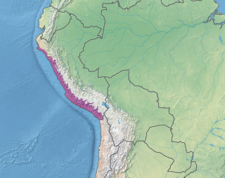
Peru is a country on the central western coast of South America facing the Pacific Ocean. It lies wholly in the Southern Hemisphere, its northernmost extreme reaching to 1.8 minutes of latitude or about 3.3 kilometres (2.1 mi) south of the equator. Peru shares land borders with Ecuador, Colombia, Brazil, Bolivia, and Chile, with its longest land border shared with Brazil.

Mali is a landlocked nation in West Africa, located southwest of Algeria, extending south-west from the southern Sahara Desert through the Sahel to the Sudanian savanna zone. Mali's size is 1,240,192 square kilometers.

Van Buren is the second largest city in the Fort Smith, Arkansas-Oklahoma Metropolitan Statistical Area and the county seat of Crawford County, Arkansas, United States. The city is located directly northeast of Fort Smith at the Interstate 40 - Interstate 540 junction. The city was incorporated in 1845 and as of the 2010 census had a population of 22,791, ranking it as the state's 22nd largest city, behind Searcy.
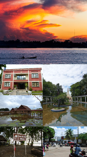
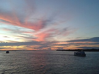
Leticia is the southernmost city in the Republic of Colombia, capital of the department of Amazonas, Colombia's southernmost town and one of the major ports on the Amazon river. It has an elevation of 96 meters (315') above sea level and an average temperature of 27 °C (80.6 °F). Leticia has long been Colombia's shipping point for tropical fish for the aquarium trade. Leticia has approximately 48,144 inhabitants on the left bank of the Amazon river, and is located at the point where Colombia, Brazil and Peru come together in an area called Tres Fronteras.
Moyobamba or Muyupampa is the capital city of the San Martín Region in northern Peru. Called "Santiago of eight valleys of Moyobamba" or "Maynas capital". There are 50,073 inhabitants, according to the 2017 census. Some 3,500 species of orchids are native to the area, which has led to the city's nickname of The City of Orchids. The city is the capital of both Moyobamba Province and Moyobamba District.
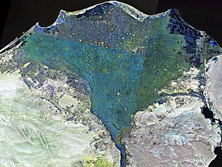
The Nile Delta is the delta formed in Lower Egypt where the Nile River spreads out and drains into the Mediterranean Sea. It is one of the world's largest river deltas—from Alexandria in the west to Port Said in the east, it covers 240 km (150 mi) of Mediterranean coastline and is a rich agricultural region. From north to south the delta is approximately 160 km (99 mi) in length. The Delta begins slightly down-river from Cairo.

Piura is a city in northwestern Peru located in the Sechura Desert on the Piura River. It is the capital of the Piura Region and the Piura Province. Its population was 484,475 as of 2017.

Ica is a department and region of Peru. It borders the Pacific Ocean on the west; the Lima Region on the north; the Huancavelica and Ayacucho regions on the east; and the Arequipa Region on the south. Its capital is the city of Ica.

Loreto is Peru's northernmost department and region. Covering almost one-third of Peru's territory, Loreto is by far the nation's largest department; it is also one of the most sparsely populated regions due to its remote location in the Amazon Rainforest. Its capital is Iquitos.

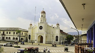
Ica is a city and the capital of the Department of Ica in southern Peru. While the area was long inhabited by varying cultures of indigenous peoples, the Spanish conquistador Jerónimo Luis de Cabrera claimed its founding in 1563.
The Sechura Desert is a coastal desert located south of the Piura Region of Peru along the Pacific Ocean coast and inland to the foothills of the Andes Mountains. Its extreme aridity is caused by the upwelling of cold coastal waters and subtropical atmospheric subsidence, but it is also subject to occasional flooding during El Niño years. In 1728, the town of Sechura was destroyed by a tsunami and was later rebuilt in its present location. In 1998, runoff from flooding rivers caused the formation of a temporary lake some 90 mi (145 km) long filling the Bayóvar Depression. Short rivers flowing across the desert from the Andes support intensive irrigation-based agriculture.

The Putumayo River or Içá River is one of the tributaries of the Amazon River, west of and parallel to the Japurá River.

Wuzhou, formerly Ngchow, is a prefecture-level city in the east of Guangxi Zhuang Autonomous Region, People's Republic of China.

Louisville is a city in Jefferson County, in the U.S. state of Kentucky. It is located at the Falls of the Ohio River.
Club Social y Deportivo Estudiantes de Medicina is a Peruvian football club from the city of Ica.

Climate of Peru describes the diverse climates of this large South American country with an area of 1,285,216 km2 (496,225 sq mi). Peru is located entirely in the tropics but features desert and mountain climates as well as tropical rainforests. Elevations above sea level in the country range from −37 to 6,778 m and precipitation ranges from less than 20 mm (0.79 in) annually to more than 8,000 mm (310 in). There are three main climatic regions: the Pacific Ocean coast is one of the driest deserts in the world but with some unique features; the high Andes mountains have a variety of microclimates depending on elevation and exposure and with temperatures and precipitation from temperate to polar and wet to dry; and the Amazon basin has tropical climates, mostly with abundant precipitation, along with sub-tropical climates in elevations above 1,550 m (5,090 ft).

The 2007 Peru earthquake, which measured 8.0 on the moment magnitude scale, hit the central coast of Peru on August 15 at 23:40:57 UTC and lasted two minutes. The epicenter was located 150 km (93 mi) south-southeast of Lima at a depth of 39 km (24 mi). The United States Geological Survey National Earthquake Information Center reported that it was a Very strong earthquake. The Peruvian government stated that 519 people were killed by the quake.
While Peru accounts for about four per cent of the world's annual renewable water resources, over 98% of its water is available east of the Andes, in the Amazon region. The coastal area of Peru, with most of economic activities and more than half of the population, receives only 1.8% of the national freshwater renewable water resources. Economic and population growth are taking an increasing toll on water resources quantity and quality, especially in the coastal area of Peru.

