
The history of Guernsey stretches back to evidence of prehistoric habitation and settlement and encompasses the development of its modern society.
Herm is one of the Channel Islands and part of the Parish of St Peter Port in the Bailiwick of Guernsey. It is located in the English Channel, north-west of France and south of England. It is 2.183 km (1.356 mi) long and under 873 metres (2,864 ft) wide; oriented north–south, with several stretches of sand along its northern coast. The much larger island of Guernsey lies to the west, Jersey lies to the south-east, and the smaller island of Jethou is just off the south-west coast.

Alderney is the northernmost of the inhabited Channel Islands. It is part of the Bailiwick of Guernsey, a British Crown dependency. It is 3 miles (5 km) long and 1+1⁄2 miles (2.4 km) wide.

Fort Grey, colloquially known as the "cup and saucer", is a Martello tower located on a tidal rock in Rocquaine Bay in Saint Peter, Guernsey on the west coast of the island.

Ortac is a small uninhabited islet about 5 kilometres west of the coast of Alderney near to the islet of Burhou. It measures roughly 50 by 70 metres, and rises 24 metres above the sea level.
La Corbière is the extreme south-western point of Jersey in St. Brélade. The name means "a place where crows gather", deriving from the word corbîn meaning crow. However, seagulls have long since displaced the crows from their coastal nesting sites.
Jersey is a heavily fortified island with coastal fortifications that date to the English Civil War, the Napoleonic Wars, and Nazi Germany's occupation of the Channel Islands. The fortifications include castles, forts, towers, Martello towers, artillery batteries, and seawalls. Not infrequently, fortifications from one period are built on the site of earlier fortifications, or very near them, geography having remained the same even when firepower increased.
The Cadomian Orogeny was a tectonic event or series of events in the late Neoproterozoic, about 650–550 Ma, which probably included the formation of mountains. This occurred on the margin of the Gondwana continent, involving one or more collisions of island arcs and accretion of other material at a subduction zone. The precise events, and geographical position, are uncertain, but are thought to involve the terranes of Avalonia, Armorica and Iberia. Rocks deformed in the orogeny are found in several areas of Europe, including northern France, the English Midlands, southern Germany, Bohemia, southern Poland and the southwest Iberian Peninsula. The name comes from Cadomus, the Latin name for Caen, northern France. L Bertrand gave the orogeny its name in 1921, naming it after Cadomus the Gaulish name for Caen in Normandy. He defined the end as being marked by Lower Palaeozoic red beds.

The Fort Hommet 10.5 cm coastal defence gun casemate bunker is a fully restored gun casemate that was part of Fortress Guernsey constructed by the forces of Nazi Germany between 1940 and 1945.

Guernsey has a geological history stretching further back into the past than most of Europe. The majority of rock exposures on the Island may be found along the coastlines, with inland exposures scarce and usually highly weathered. There is a broad geological division between the north and south of the Island. The Southern Metamorphic Complex is elevated above the geologically younger, lower lying Northern Igneous Complex. Guernsey has experienced a complex geological evolution with multiple phases of intrusion and deformation recognisable.
This page list topics related to the Bailiwick of Guernsey, including Guernsey, Alderney, Sark and smaller islands.

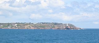
Jerbourg Point or the Jerbourg Peninsula is the southeastern point of the Bailiwick of Guernsey in the English Channel off the coast of Normandy, lying within St Martin Parish. It marks the end of the east coast cliffs and beginning of the south coast cliffs. It provides scenic views of the Little Russel and the various islands.

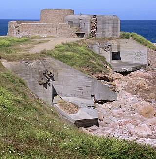
Battery Lothringen was a World War II coastal artillery battery in Saint Brélade, Jersey, named after the SMS Lothringen, and constructed by Organisation Todt for the Wehrmacht during the Occupation of the Channel Islands. The first installations were completed in 1941, around the same time as the completion of the nearby Battery Moltke, in St. Ouen.

The Bréhon Tower is accessible only by boat and sits on Bréhon Rock, an island in the Little Russell channel about 1.5 km northeast of St Peter Port, Guernsey, between the port and the islands of Herm and Jethou. Thomas Charles de Putron (1806–1869) built the oval tower of granite from Herm, completing the work in 1857.

Fort Saumarez is a Martello tower in Saint Peter, Guernsey, on a headland that forms the northern tip of L'Erée and extends to the Lihou causeway.

Fort Hommet is a fortification on Vazon Bay headland in Castel, Guernsey. It is built on the site of fortifications that date back to 1680, and consists of a Martello tower from 1804, later additions during the Victorian Era, and bunkers and casemates that the Germans constructed during World War II.

The British built 15 Guernsey loophole towers at various points along the coast of Guernsey between August 1778 and March 1779 to deter possible French attacks after France had declared itself an ally of the Americans in the American Revolutionary War. Towards the start of the Napoleonic Wars several towers received additional reinforcement in the form of batteries at their bases. Today, 12 towers still survive, three having been destroyed at different times. Two of the survivors, Petit Bôt and Rousse, contain interpretive exhibits that the public may examine.
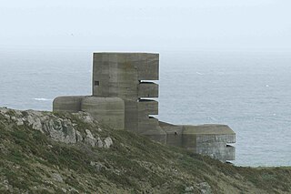
After the Wehrmacht occupied the Channel Islands on 30 June 1940, they assessed the existing defences to determine if they would be of use. The Germans found the Islands' fortifications antiquated and woefully inadequate for modern warfare.

Apart from a Roman Fort, there were very few fortifications in Alderney until the mid 19th century. These were then modified and updated in the mid 20th Century by Germans during the occupation period. Alderney at 8 km2 is now one of the most fortified places in the world.
The island of Guernsey has been fortified for several thousand years, the number of defence locations and complexity of the defence increasing with time, manpower and the improvements in weapons and tactics.
