
The Nigerian Air Force (NAF) is the air branch of the Nigerian Armed Forces. It is the youngest branch of the Nigerian Armed Forces. It is one of the largest in Africa, consisting of over 18,000 personnel as at 2021 and aircraft including 9 Chengdu F-7s, 11Dassault-Dornier Alpha Jets, three JF-17 Thunder Block II and 12 Embraer EMB 314 Super Tucano aircraft, 24 Ameracchi M-346 FAs on order, attack helicopters, armed attack drones, and military transport aircraft.
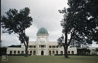
Kaduna is the capital city of Kaduna State, and the former political capital of Northern Nigeria. It is located in north-western Nigeria, on the Kaduna River. It is a trade center and a major transportation hub as the gateway to northern states of Nigeria, with its rail and important road network.
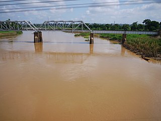
The Kaduna River is a tributary of the Niger River which flows for 550 kilometres (340 mi) through Nigeria. It got its name from the crocodiles that lived in the river and surrounding area. Kaduna in the native dialect, Hausa, was the word for "crocodiles". It starts in Plateau State on the Jos Plateau 29 kilometres (18 mi) southwest of Jos town, flows through its namesake Kaduna State and through its capital Kaduna, and meets the Niger River in Niger State. Most of its course passes through open savanna woodland, but its lower section has cut several gorges above its entrance into the extensive Niger floodplains. The river is used for fishing and transport of local produce.

Kaduna State is a state in the northwest geopolitical zone of Nigeria. The state capital is its namesake, the city of Kaduna which happened to be the 8th largest city in the country as at 2006. Created in 1967 as North-Central State, which also encompassed the modern Katsina State, Kaduna State achieved its current borders in 1987. Kaduna State is the fourth largest and third most populous state in the country, Kaduna State is nicknamed the Centre of Learning, owing to the presence of numerous educational institutions of importance within the state such as Ahmadu Bello University.

Zaria is a metropolitan city in Nigeria which lies within four local government areas in Kaduna State; it is the capital city to the Zazzau Emirate Council, and one of the original seven Hausa city-states and a major city in the state. The local government areas that made up of the city of Zaria includes: Zaria Local Government, Sabon Gari Local Government, Giwa Local Government and Soba Local Government areas in Kaduna state, Nigeria.
Gombe is the capital city of Gombe State, north-eastern Nigeria, with an estimated population of 573, 000. The major spoken languages in Gombe are Hausa and Fulfulɗe, Tera and Tangale.
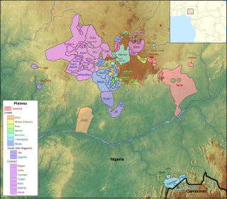
The forty or so Plateau languages are a tentative group of Benue–Congo languages spoken by 15 million people on the Jos Plateau, Southern Kaduna, Nasarawa State and in adjacent areas in central Nigeria.

Nigerian Railway Corporation is the state-owned enterprise with exclusive rights to operate railways in Nigeria.
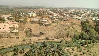
Kafanchan is a town located in the southern part of Kaduna State, Nigeria. The town owes much of its development to the railway development in the area. The railway is situated at a particular junction of the Nigerian Railway Corporation (NRC) station built in 1927. It sits on the railtrack connecting Port Harcourt, Enugu, Kafanchan, Kuru, Bauchi and finally Maiduguri. As of 2007, Kafanchan had an estimated population of 83,092.

Railways in Nigeria consist of a 3,505 km Cape gauge national railway network and 669 km of standard gauge. The Cape gauge network is in poor condition due to lack of maintenance. In 2019, the single operational standard gauge line from Abuja to Kaduna generated as much revenue as the entire Cape gauge railway network combined. The Nigerian government plans to extend the standard gauge to replace most of the Western Line, while the Eastern Line will be rehabilitated as a Cape gauge line. All trains in Nigeria are operated by the Nigerian Railway Corporation.
Munya is a Local Government Area in Niger State, Nigeria. Its headquarters are in the town of Sarkin Pawa in the north of the area near Kaduna State at10°01′00″N7°06′00″E.

Railway stations in Nigeria include:
Kajuru is a local government area in southern Kaduna State, Nigeria. Its also headquarters is in the town of Kajuru. The local government is located on longitude 9° 59'N and 10° 55'N and latitude 7° 34'E and 8° 13'E, with an area of 2,229 km2.
Sanga is a Local Government Area in southern Kaduna State, Nigeria. Its headquarters is in the town of Gbantu. The Local Government Council is chaired by Bisallah Malam. It has an area of 1,821 km2 and had a population of 151,485 as at the 2006 census. The postal code of the area is 801.
Jema'a is a Local Government Area in southern Kaduna State, Nigeria with headquarters at Kafanchan. The Local Government Council is chaired by Yunana Barde. It has an area of 1,384 km2 and a population of 278,202 at the 2006 census. The postal code of the area is 801.
Ajuwa (Ajegha) is a Plateau language of Kaduna State, Nigeria. It is spoken in Kalla, Afogo, Iburu, Idon, and Makyali towns. Ajuwa was reported by Roger Blench (2019), but is not reported in Ethnologue or Glottolog. Blench classifies it as Northwestern.

Southern Kaduna is an area of the Nok Culture region inhabited by primarily various non-Hausa speaking peoples living south of Zaria, Kaduna State. It is located in the Middle Belt region of Nigeria. Southern Kaduna consists of 12 Local Government Areas out of a total of 23 in Kaduna State. Some view it as being less of a geographical identity and more of an ethnic identity concept.
On 5 June 2022, alleged Fulani militants killed thirty-two civilians in four villages in the Kajuru area of Kaduna State, Nigeria.
Damakasuwa is a town and headquarters of the Tsam Chiefdom of the Atsam people in Kauru Local Government Area in southern Kaduna state in the Middle Belt region of Nigeria. The postal code of the area is 811.
Chawai is a town east of the headquarters of the Tsam Chiefdom of the Atsam people in Kauru Local Government Area in southern Kaduna state in the Middle Belt region of Nigeria. The postal code of the area is 811.


