Idrijski Log

Last updated • 4 min readFrom Wikipedia, The Free Encyclopedia
Idrijski Log
Idrijski Log Slovenia.JPG
Slovenia location map.svg
Red pog.svg
Idrijski Log
Location in Slovenia
Coordinates: 45°57′41.06″N14°2′14.6″E / 45.9614056°N 14.037389°E / 45.9614056; 14.037389
Country Flag of Slovenia.svg Slovenia
Traditional region Inner Carniola
Statistical region Gorizia
Municipality Idrija
Area
  Total11.67 km2 (4.51 sq mi)
Elevation
650 m (2,130 ft)
Population
 (2002)
  Total87
[1]

Idrijski Log (pronounced [ˈiːdɾii̯skiˈloːk] ; German : Idriskilog, [2] Italian : Loga d'Idria [3] ) is a dispersed settlement on the right bank of the upper course of the Idrijca River in the hills south of Idrija in the traditional Inner Carniola region of Slovenia. [2] In addition to the settlement of Idrijski Log itself, it also includes the hamlets of Koševnik and Na Pevcu. [4]

Contents

Geography

Idrijski Log lies on the north end of the Črni Vrh Plateau, which then drops sharply to the Idrijca Valley. It is connected to the hamlet of Podroteja in Idrija by a gravel road with a series of switchbacks and to Godovič by a route known as the French Road (Slovene : francoska cesta), which also leads to Črni Vrh and connects to Zadlog. The settlement lies on heavily karstified wooded land with many karst shafts and losing streams. [4] The main elevations are Krog Hill (794 m), The Hill (Na Griču, 760 m) Grapar Peak (Graparjev vrh, 739 m), Pevc Hill (728 m), Big Peak (Veliki vrh, 721 m), Juniper Hill (Brinov grič, 738 m), Klobučar Hill (694 m), Skalovnik Hill (604 m). [5] [6] Karst caves include the Andrejček Shaft (Andrejčkov brezen) in the hamlet of Koševnik, and the Habeček Shaft (Habečkov brezen) south of this. The water in the shafts drains into Wild Lake and nearby karst springs in Podroteja. Intermittent springs include Pevc Spring (Pevški studenec) and Cold Spring (Mrzli studenec). The most significant watercourse is Mlaka Creek, which disappears into the ground near the Habe farm and formerly powered mills. [4]

Name

The name Idrijski Log literally means 'Idrija meadow'. The name Log is shared with many other settlements in Slovenia and is derived from the Slovene word log 'a partially forested (marshy) meadow near water' or 'woods near a settlement'. [7] It was known as Loga d'Idria in Italian. [3]

Mass graves

Idrijski Log is the site of two known mass graves from the period immediately after the Second World War. The Ajhar Shaft Mass Grave (Slovene : Grobišče Ajharjevo brezno) is located northwest of the village, about 600 meters (2,000 ft) north of the Mohorič farm (Idrijski Log no. 23), along an abandoned road. It contains the remains of unknown victims murdered in late May 1945. [8] The Andrejček Shaft Mass Grave (Grobišče Andrejčkovo brezno) lies in a sinkhole alongside the road from Idrijski Log to Idrija, northeast of the settlement. It contains the remains of an unknown number of Slovene and Italian civilian prisoners that were brought from Trieste and Gorizia and murdered here in late May or on 13 June 1945. [9]

Cultural heritage

Several structures in Idrijski Log are registered as cultural heritage:

Notable people

Notable people that were born or lived in Idrijski Log include:

Related Research Articles

<span class="mw-page-title-main">Uršna Sela</span> Place in Lower Carniola, Slovenia

Uršna Sela is a settlement south of Novo Mesto in southeastern Slovenia. The railway line from Ljubljana to Metlika runs through the settlement. The area is part of the traditional region of Lower Carniola and is now included in the Southeast Slovenia Statistical Region.

<span class="mw-page-title-main">Podgorje, Kamnik</span> Place in Upper Carniola, Slovenia

Podgorje is a settlement that is a now a suburb of the town of Kamnik in the Upper Carniola region of Slovenia.

<span class="mw-page-title-main">Črni Vrh, Dobrova–Polhov Gradec</span> Place in Upper Carniola, Slovenia

Črni Vrh is a dispersed settlement in the hills northwest of Polhov Gradec in the Municipality of Dobrova–Polhov Gradec in the Upper Carniola region of Slovenia. It includes many isolated farms scattered throughout the hills between Big Božna Creek to the south, Little Božna Creek to the northeast, Dog Plateau to the northwest, and Špilj Hill to the south-southeast.

<span class="mw-page-title-main">Zakriž</span> Place in Littoral, Slovenia

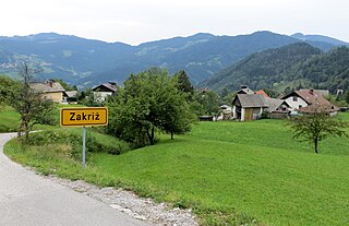
Zakriž is a settlement northwest of Cerkno in the traditional Littoral region of Slovenia.

<span class="mw-page-title-main">Črni Vrh, Idrija</span> Place in Inner Carniola, Slovenia

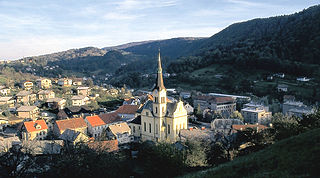
Črni Vrh is a settlement in the hills south of Idrija in the traditional Inner Carniola region of Slovenia. It includes the hamlets of Zgornja Vas, Spodnja Vas, Trate, Trebče, and Zidiše.

Predgriže is a settlement northeast of Črni Vrh in the Municipality of Idrija in the traditional Inner Carniola region of Slovenia. The village includes the hamlets of Gornje Griže, Klavžar, Nagode, Na Vrhu, Smrekar, Spodnje Griže, and Žgavec.

<span class="mw-page-title-main">Vrh Svetih Treh Kraljev</span> Place in Inner Carniola, Slovenia

Vrh Svetih Treh Kraljev is a dispersed settlement in the hills north of Rovte in the Municipality of Logatec in the Inner Carniola region of Slovenia.

<span class="mw-page-title-main">Žažar</span> Place in Inner Carniola, Slovenia

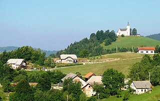
Žažar is a village in the hills southwest of Horjul in the Inner Carniola region of Slovenia. It includes the hamlet of Razpotje.

Hrovača is a settlement immediately to the southeast of the town of Ribnica in southern Slovenia. It lies just south of the town of Ribnica. The area is part of the traditional region of Lower Carniola and is now included in the Southeast Slovenia Statistical Region.

<span class="mw-page-title-main">Jelenov Žleb</span> Place in Lower Carniola, Slovenia

Jelenov Žleb is a small remote settlement in the hills south of Ribnica in southern Slovenia. It no longer has any permanent residents, but is used seasonally by local forest workers. The area is part of the traditional region of Lower Carniola and is now included in the Southeast Slovenia Statistical Region.

Škrajnek is a small settlement north of Velike Poljane in the Municipality of Ribnica in southern Slovenia. The entire municipality is part of the traditional region of Lower Carniola and is now included in the Southeast Slovenia Statistical Region.

<span class="mw-page-title-main">Gornji Ig</span> Place in Inner Carniola, Slovenia

Gornji Ig is a village in the hills southwest of Iška Vas in the Municipality of Ig in central Slovenia. The entire municipality is part of the traditional region of Inner Carniola and is now included in the Central Slovenia Statistical Region.

<span class="mw-page-title-main">Dol pri Hrastniku</span> Place in Styria, Slovenia

Dol pri Hrastniku is a settlement in the Municipality of Hrastnik in central Slovenia. The area is part of the traditional region of Styria. It is now included with the rest of the municipality in the Central Sava Statistical Region. In addition to the main settlement, it includes the hamlets of Črdenc, Grča, Javorje, Novi Dol, Pod Bregom, Rakovec, and Slatno.

<span class="mw-page-title-main">Bele Vode, Šoštanj</span> Place in Styria, Slovenia

Bele Vode is a settlement in the Municipality of Šoštanj in northern Slovenia. It lies in the Mozirje Hills northwest of the town of Šoštanj. The area is part of the traditional region of Styria. The entire municipality is now included in the Savinja Statistical Region. The settlement includes the hamlets of Kloše, Punčkov Vrh, Visočki Vrh, and Zaloka.

<span class="mw-page-title-main">Trebanjski Vrh</span> Place in Lower Carniola, Slovenia

Trebanjski Vrh is a settlement in the Municipality of Trebnje in eastern Slovenia. The area is part of the historical region of Lower Carniola. The municipality is now included in the Southeast Slovenia Statistical Region.

<span class="mw-page-title-main">Podstenice</span> Place in Lower Carniola, Slovenia

Podstenice is a settlement in the Municipality of Dolenjske Toplice in Slovenia. It was inhabited by Gottschee Germans. At the start of the Second World War its population was expelled and in 1942 the village was burned to the ground. The area is part of the historical region of Lower Carniola. The municipality is now included in the Southeast Slovenia Statistical Region.

Vrh pri Boštanju is a settlement in the hills southwest of Boštanj in the Municipality of Sevnica in east-central Slovenia. The area is part of the historical region of Lower Carniola. The municipality is now included in the Lower Sava Statistical Region. The settlement includes the hamlets of Dule, Pleček, Gabrnik, Ravne, Topolovec, Grič, Hrib, Dobje, Reviše, Volčje Jame, Drče, Okič, Sleme, Drenovec, Straški Hrib, and Lipoglav.

<span class="mw-page-title-main">Vojko's Plaque</span>

Vojko's Plaque is a local landmark in the Idrijca Gorge in the settlement of Idrijski Log, western Slovenia. This is a plaque that marks the site where the Partisan fighter Janko Premrl was mortally wounded on 15 February 1943. He died a week later, on 22 February 1943, at Brin Hill in Idrijski Log.

<span class="mw-page-title-main">Janko Premrl</span>

Janko Premrl was a Slovene Partisan.

<span class="mw-page-title-main">Glinica (Ljubljana)</span> Place in Upper Carniola, Slovenia

Glinica is a former settlement in central Slovenia in the northwest part of the capital Ljubljana. It belongs to the Dravlje District of the City Municipality of Ljubljana. It is part of the traditional region of Upper Carniola and is now included with the rest of the municipality in the Central Slovenia Statistical Region.

References

  1. Statistical Office of the Republic of Slovenia
  2. 1 2 Leksikon občin kraljestev in dežel zastopanih v državnem zboru, vol. 6: Kranjsko. 1906. Vienna: C. Kr. Dvorna in Državna Tiskarna, p. 124.
  3. 1 2 Venézia Giúlia e Dalmázia. 1934. Milan: Touring club italiano, p. 252.
  4. 1 2 3 4 Savnik, Roman, ed. 1968. Krajevni leksikon Slovenije, vol. 1. Ljubljana: Državna založba Slovenije, p. 73.
  5. Idrijski Log on Geopedia
  6. Idrijski Log at Pespoti.si
  7. Snoj, Marko. 2009. Etimološki slovar slovenskih zemljepisnih imen. Ljubljana: Modrijan and Založba ZRC, p. 243.
  8. Ferenc, Mitja (December 2009). "Grobišče Ajharjevo brezno". Geopedia (in Slovenian). Ljubljana: Služba za vojna grobišča, Ministrstvo za delo, družino in socialne zadeve. Retrieved October 6, 2023.
  9. Ferenc, Mitja (December 2009). "Grobišče Andrejčkovo brezno". Geopedia (in Slovenian). Ljubljana: Služba za vojna grobišča, Ministrstvo za delo, družino in socialne zadeve. Retrieved October 6, 2023.
  10. Slovenian Ministry of Culture register of national heritage reference number ešd 13818
  11. Slovenian Ministry of Culture register of national heritage reference number ešd 13820
  12. Slovenian Ministry of Culture register of national heritage reference number ešd 21169
  13. Slovenian Ministry of Culture register of national heritage reference number ešd 13819
  14. Slovenian Ministry of Culture register of national heritage reference number ešd 4802
  15. Slovenian Ministry of Culture register of national heritage reference number ešd 13821
  16. Slovenian Ministry of Culture register of national heritage reference number ešd 13822