
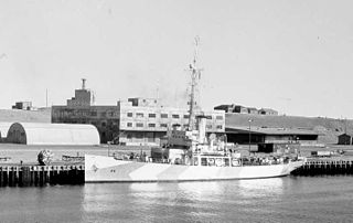
USS Edisto (AGB-2) was a Wind-class icebreaker in the service of the United States Navy and was later transferred to the United States Coast Guard as USCGC Edisto (WAGB-284). She was named after Edisto Island, South Carolina. The island is named after the Native American Edisto Band who inhabited the island and the surrounding area. As of 2011 there is a namesake cutter USCGC Edisto (WPB-1313). The newer Edisto is a 110-foot Island-class patrol boat and is stationed in San Diego County, California.

USCGC Northwind (WAG/WAGB-282) was a Wind-class icebreaker, the second United States Coast Guard Cutter of her class to bear the name. She was built to replace USCGC Staten Island which was in Soviet lend-lease service.
USCGC Modoc (WPG-46) was a 240-foot Tampa-class United States Coast Guard cutter designed for multi-mission roles. She had a top speed of sixteen knots, and was armed with a pair of 5-inch deck guns. With the breakout of war she was armed with depth charges, additional guns, sonar, and radar and transferred to the Navy. Modoc, along with her sister ships Mojave and Tampa joined the Greenland Patrol.
The history of the United States Coast Guard goes back to the United States Revenue Cutter Service, which was founded on 4 August 1790 as part of the Department of the Treasury. The Revenue Cutter Service and the United States Life-Saving Service were merged to become the Coast Guard per 14 U.S.C. § 1 which states: "The Coast Guard as established January 28, 1915, shall be a military service and a branch of the armed forces of the United States at all times." In 1939 the United States Lighthouse Service was merged into the Coast Guard. The Coast Guard itself was moved to the Department of Transportation in 1967, and on 1 March 2003 it became part of the Department of Homeland Security. However, under 14 U.S.C. § 3 as amended by section 211 of the Coast Guard and Maritime Transportation Act of 2006, upon the declaration of war and when Congress so directs in the declaration, or when the President directs, the Coast Guard operates as a service in the Department of the Navy.
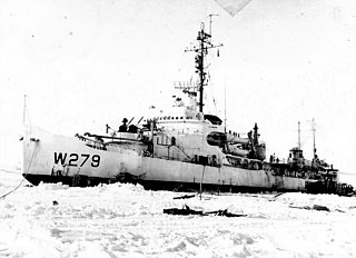
USCGC Eastwind (WAGB-279) was a Wind-class icebreaker that was built for the United States Coast Guard. Completed in time to see action in World War II, she continued in USCG service under the same name until decommissioned in 1968.

The fall of Denmark in April 1940 left the Danish colony of Greenland an unoccupied territory of an occupied nation, under the possibility of seizure by the United Kingdom, United States or Canada. To forestall this, the United States acted to guarantee Greenland's position. With the entrance of the United States into the war in December 1941, Greenland became a combatant.

USS Unimak (AVP-31) was a United States Navy Barnegat-class small seaplane tender in commission from 1943 to 1946 that saw service in World War II. After the war, she was in commission in the United States Coast Guard as the cutter USCGC Unimak (WAVP-379), later WHEC-379, WTR-379, and again WHEC-379, from 1949 to 1975 and from 1977 to 1988.

Clavering Island is a large island in eastern Greenland off Gael Hamke Bay, to the south of Wollaston Foreland.

Edward Hanson "Iceberg" Smith was a United States Coast Guard admiral, oceanographer, and Arctic explorer. He was born 29 October 1889 at Vineyard Haven, Massachusetts. He received a Ph.D. in oceanography from Harvard, and commanded the USCGC Marion and the USCGC Northland. Most famously, he commanded the Greenland Patrol, and led Coast Guard efforts to defend Greenland against the Germans in World War II. After retirement from the Coast Guard, he assumed the directorship of Woods Hole Oceanographic Institution.
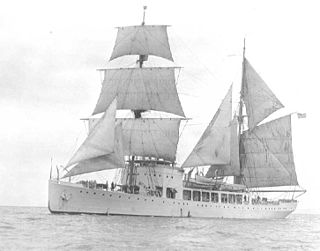
USCGC Northland (WPG-49) was a United States Coast Guard cruising class of gunboat especially designed for Arctic operations in commission from 1927 to 1938 and from 1939 to 1946. She served during World War II. She was the last cruising cutter built for the Coast Guard equipped with a sailing rig.

USCGC Tampa was a United States Coast Guard Cutter that served in the United States Coast Guard from 1921 to 1941, and then in the United States Navy from 1941 to 1947.

The second USS Barataria (AVP-33) was a United States Navy Barnegat-class seaplane tender in commission from 1944 to 1946. She saw service in the later stages of World War II and was decommissioned postwar. She then was transferred to the United States Coast Guard and was in commission as the Coast Guard cutter USCGC Barataria (WAVP-381), later WHEC-381 from 1949 to 1969, serving in the Cuban Missile Crisis and the Vietnam War during her lengthy Coast Guard career.
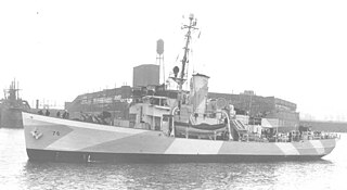
USCGC Comanche (WPG-76) was a United States Coast Guard cutter built by Pusey & Jones Corporation, Wilmington, Delaware, and launched 6 September 1934. She was commissioned on 1 December 1934. She was used extensively during World War II for convoy operations to Greenland and as a part of the Greenland Patrol.

Bluie East Two was a minor United States Army Air Forces airfield at Ikateq in eastern Greenland. It was operational from 1942 to 1947.
Simiutaq, old spelling Simiutak, is an uninhabited island in the Kujalleq municipality in southwestern Greenland. During the Second World War and after Simiutak was the site of a U.S. Navy facility code-named 'Bluie West 3'.
Bluie West 7 or Grondal was a major U.S. naval operating facility near Ivigtut in Arsuk Fjord, Greenland. In some form, it was in operation from 1940 to 1951, although its formal establishment by the U.S. Navy was on 1 April 1943. After 1942, the proper name was Grønnedal (Danish), or Green Valley (English), but the base was also called Grondal by Americans. Bluie was the military code name for Greenland. It was three miles east of the Ivigtut cryolite mine. The location's local name in use today is Kangilinnguit. The Arsuk Fjord approach is accessible by sea year-round, though with occasional ice-breaking assistance, and is known as an exceptionally scenic area.

The USCGC North Star was a United States Coast Guard Cutter during the Second World War. It was originally built for the U.S. Interior Department and served in the United States Coast Guard (USCG) before being acquired by the U.S. Navy.

The Greenland Patrol was a United States Coast Guard operation during World War II. The patrol was formed to support the U.S. Army building aerodrome facilities in Greenland for ferrying aircraft to the British Isles, and to defend Greenland with special attention to preventing German operations in the northeast. Coast Guard cutters were assisted by aircraft and dog sled teams patrolling the Greenland coast for Axis military activities. The patrol escorted Allied shipping to and from Greenland, built navigation and communication facilities, and provided rescue and weather ship services in the area from 1941 through 1945.

Odinland, also Odinsland in the Defense Mapping Agency Greenland Navigation charts, is a peninsula in the King Frederick VI Coast, southeastern Greenland. It is a part of the Sermersooq municipality.

Benjamin Bottoms was a United States Coast Guardsman who died while attempting to rescue the crew of a USAAF bomber that had crashed-landed in Greenland in November 1942. Bottoms was the radioman of the USCGC Northland's Grumman J2F-4 Duck floatplane. When a B-17 bomber crash landed near Northland his aircraft was assigned to search for it. Bottoms's pilot Lieutenant John A. Pritchard sighted the bomber, and landed as close to the wreck as possible—four miles away. Pritchard and Bottoms were able to assist two of the injured bomber crew to their plane, and take them back to Northland. However, on their second rescue visit they encountered bad weather, and crashed. It took seventy-five years to locate their bodies.


