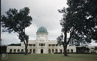
Kaduna is the capital city of Kaduna State, and the former political capital of Northern Nigeria. It is located in north-western Nigeria, on the Kaduna River. It is a trade center and a major transportation hub as the gateway to northern states of Nigeria, with its rail and important road network.

Kaduna State is a state in the northwest geopolitical zone of Nigeria. The state capital is its namesake, the city of Kaduna, which was the 8th largest city in the country as of 2006. Created in 1967 as North-Central State, which also encompassed the modern Katsina State, Kaduna State achieved its current borders in 1987. Kaduna State is the fourth largest and third most populous state in the country, Kaduna State is nicknamed the Centre of Learning, owing to the presence of numerous educational institutions of importance within the state such as Ahmadu Bello University.

Northern Nigeria was an autonomous division within Nigeria, distinctly different from the southern part of the country, with independent customs, foreign relations and security structures. In 1962, it acquired the territory of the British Northern Cameroons, which voted to become a province within Northern Nigeria.

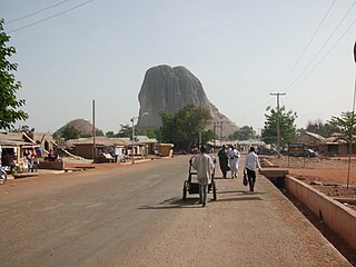
Zaria is a metropolitan city in Nigeria, located at present time within four local government areas in Kaduna State. It serves as the capital of the Zazzau Emirate Council and is one of the original seven Hausa city-states. The local government areas comprising Zaria are Zaria, Sabon Gari, Giwa, and Soba local government areas of Kaduna State, Nigeria.

Katagum is a town, a local government area and a traditional emirate in Bauchi State of north eastern Nigeria. The town is located on the northern bank of the Jama'are River, which is a tributary of the Hadejia. Most of the inhabitants are peoples from the Fulani, Kanuri, Karai-karai and Hausa tribes. The chief agricultural products include peanuts (groundnuts), sorghum, millet, rice, cowpeas, cotton, indigo, and gum arabic. Livestock include horses, cattle, goats, sheep, donkeys and a lot of poultry.
Suleja is a city in Niger State, Nigeria, just north of Abuja, capital of the Nigeria. It is sometimes confused with the nearby city of Abuja, due to its proximity, and the fact that it was originally called Abuja before the Nigerian government adopted the name from the then Emir Sulayman Bal for its new federal capital in 1976.
Wase is a town and Local Government Area (LGA) of Plateau State, Nigeria, situated some 216 km south east of Jos, the Plateau State capital. It shares its name with the nearby Wase River. The population of the LGA was 159,861 people as of 2006, with an urban area of 1750 km².
The Zazzau, also known as the Zaria Emirate, is a traditional state with headquarters in the city of Zaria, Kaduna State, Nigeria. The current emir of Zazzau is Ahmed Nuhu Bamalli CFR, who succeeded the former emir, late Alhaji Shehu Idris.
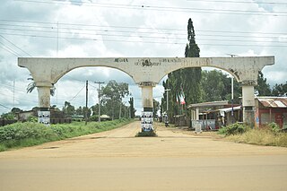
Kafanchan is a town located in the southern part of Kaduna State, Nigeria. The town owes much of its development to the railway development in the area. The railway is situated at a particular junction of the Nigerian Railway Corporation (NRC) station built in 1927. It sits on the railtrack connecting Port Harcourt, Enugu, Kafanchan, Kuru, Bauchi and finally Maiduguri. As of 2007, Kafanchan had an estimated population of 83,092.
Danja is a Local Government Area in Katsina State, Nigeria. Its headquarters is located in the town of Danja.
Minjibir is a Local Government Area in Kano State, Nigeria. Its headquarters are in the town of Minjibir, about 20 km northeast of the state capital Kano.
Karaye is a Local Government Area and Headquarter of Karaye Emirate Council in Kano State, Nigeria. Its headquarters are in the town of Karaye.
Rano is a Local Government Area and headquarters of Rano Emirate council in Kano State, Nigeria. Rano is a local government area in Kano State with administrative headquarters in the town of Rano. Rano local government area is a Hausa-Fulani community in the southern senatorial district of Kano State otherwise known as Kano South Senatorial District alongside Albasu, Bebeji, Bunkure, Doguwa, Gaya, Kiru, Takai, Ajingi, Rogo, Kibiya, Tudun Wada, Garko, Wudil and Sumaila local government areas. Rano local government area also forms a federal constituency alongside Bunkure and Kibiya local government areas. It has an area of 520 km2 and a population of 145,439 at the 2006 census. The local government area is bounded to the north by Garun Mallam and Bunkure local government areas, to the east by Kibiya local government area, to the south by Tudun Wada local government area, and to the west by Bebeji local government area. The Rano local government council is in charge of public administration in Rano local government area. The council is led by a chairman who is the executive head of the local government. The Rano legislative council make laws governing Rano local government area. It consists of 10 Councillors representing the 10 wards of the local government area.
Sanga is a Local Government Area in southern Kaduna State, Nigeria. Its headquarters is in the town of Gbantu. The Local Government Council is chaired by Bisallah Malam. It has an area of 1,821 km2 and had a population of 151,485 as at the 2006 census. The postal code of the area is 801.
Jema'a is a Local Government Area in southern Kaduna State, Nigeria with headquarters at Kafanchan. The Local Government Council is chaired by Yunana Barde. It has an area of 1,384 km2 and a population of 278,202 at the 2006 census. The postal code of the area is 801.
Kagarko is a Local Government Area in southern Kaduna State of Nigeria. Its headquarters are in the town of Kagarko. It has an area of 2,356 km2 and a population of 239,058 at the 2006 census. The Local Government Council is chaired by Nasara Rabo. The postal code is 802.
Lere is a Local Government Area and town in the southern part of Kaduna State, Nigeria. Lere town is located geographically at the latitude of 10 degrees 39 North and longitude of 8 degrees 57 East. It is the headquarters of the Lere Emirate. The town and its environs have an estimated population of about 553,290 (2016). Lere Local Government has an area of 2,634 km2 and a population of 339,740 at the 2006 census. Its headquarters are in the town of Saminaka. The postal code of the area is 811.
Kubau Local Government Area is one of the 23 Local Government Areas in Kaduna State, Nigeria. It has its headquarters in the town of Anchau. The Local Government Council is chaired by Bashir Zuntu. The present Chairman Hon. Bashir Zuntu.

The Emir of Zazzau, known as Sarkin Zazzau in the Hausa language, is the traditional ruler based in Zaria, which was also known as Zazzau in the past. Although in centuries past, the emirs ruled as absolute monarchs, in the 20th and 21st centuries Nigerian traditional rulers hold little constitutional power, but wield considerable behind-the-scenes influence on the government. The emir's residence is in the historic palace in the town of Zaria.
The genesis of the 1992 Zangon Kataf crises could at least be traced to the onset of the British imperial regime in the Northern Region of Nigeria, in which the Atyap people began reporting the loss of land to the Hausas. In 1922, it was reported that a large piece of land was acquired by the Emir of Zaria, Dalhatu Uthman Yero, who failed to compensate the indigenous population of the region. In 1966, the land was provided to the Hausa trading settlement in the heart of Mabatado, called "Zangon Kataf", by the emir, Muhammad Usman. The Atyap resided within the district, in the Zaria Province of the Northern Region of, initially, British Nigeria, which became independent Nigeria. It was to remain utilized as a marketplace, where the indigenous Atyap people were banned from trading pork and beer by the settlers.

