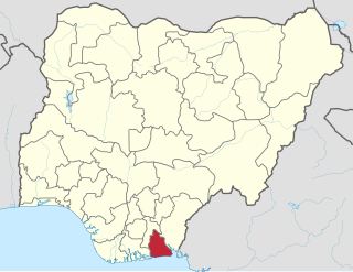
Akwa Ibom State is a state in the South-South geopolitical zone of Nigeriaon the east by Cross River State, on the west by Rivers State and Abia State, and on the south by the Atlantic Ocean. The state takes its name from the Qua Iboe River which bisects the state before flowing into the Bight of Bonny. Akwa Ibom was split from Cross River State in 1987 with its capital Uyo and with 31 local government areas.

The Ibibio people are a coastal people in southern Nigeria. They are mostly found in Akwa Ibom and Cross River States. They are related to the Efik people. During the colonial period in Nigeria, the Ibibio Union asked for recognition by the British as a sovereign nation.
The Anaang are an ethnic group in southern Nigeria, whose land is primarily within 8 of the present 31 local government areas in Akwa Ibom State: Abak, Essien Udim, Etim Ekpo, Ika, Ikot Ekpene, Obot Akara, Oruk Anam, Ukanafun in Akwa Ibom State. The Anaang are the second largest ethnic group in Akwa Ibom state.
Abak is a town and Local Government Area in Akwa Ibom State, Nigeria. The LGA was previously part of Cross River State. It was later sub divided into other local government areas such as Oruk Anam, Etim Ekpo, Ukanafun and Ika. Notable tribes include the Annang. The major economic activities of the people of this area before and after the Nigerian civil war was palm produce exported through river port at Ekpene Okpo, Ntak Ibesit, a distance of about 8 km from Abak town. Abak town, the local government headquarters is located about 18 kilometres from Uyo, the State capital. It has a landmass of 304 square kilometers. Abak to say the least, is the shadow of its former self due to politically motivated neglect by successive governments in Akwa Ibom state. Abak was the economic hub of the former Southeastern Nigeria before the civil war. The Nigerian Army barrack that is popularly known as Ibagwa Barrack is located or can be found in the Abak.
Ikot Ekpene, also known as The Raffia City, is a historic town in south-southern state of Akwa Ibom. It is the political and cultural capital of the Annang ethnic group in Nigeria. The town is located on the A342 highway that parallels the coast, between Calabar to the south east and Aba to the west, with the state capital, Uyo, on this road just to the east. Umuahia is the next major town to the north.
Ikot Okoro is a rural settlement of Akwa Ibom State and was one of the larger population concentrations in the now defunct South Eastern Nigeria. Now smaller, it is about 15 km (9.3 mi) southwest of the regional center of Abak. The people of Ikot Okoro have been clamoring for the creation of a local Government area (LGA) from the present day Oruk Anam LGA. Oruk Anam LGA incidentally happens to be one of the biggest LGA in Nigeria and as such grassroots development have not been felt in most part of the LGA especially in Ikot Okoro. It is noteworthy to state that successive administrations in the past have neglected this once prosperous and dynamic area. It is the belief of the general population that once the actualization of the Annang State or ITAI state is achieved, Ikot Okoro will reclaim its lost glory.
Oruk Anam is a Local Government Area located in the southwestern part of Akwa Ibom State, Nigeria. It may be ranked as the largest LGA in Akwa-ibom due to its land popularity. Its headquarters are located in the town of Ikot Ibritam. It is one of the eight Annang-speaking local government areas.
Etim Ekpo is a town and Local Government Area in Akwa Ibom State, Nigeria. The area has 11 wards.
Ikono is a Local Government Area of Akwa Ibom State, located in the South South of Nigeria. It is bounded at the North by Ini Local Government Area, South by Abak and Uyo Local Government Areas, East by Ibiono Ibom Local Government Area and West by Ikot Ekpene,Essien Udim and Obot Akara Local Government Areas. It was created a stand alone local government in september 1996. It has a landmass of 407.16 square kilometres (157.21 sq mi). It is no doubt one of the four largest LGA in Akwa Ibom and also known as the cradle of the Ibibio people [Ntippe Ibibio]. It occupies the northern fringe of Akwa-Ibom State next to Ini local Government which occupies the northern most fringe of the state. It is predominantly inhabited by the Ibibios, the largest ethnic groups in the state. Some popular sub-groups within Ikono include Ukpom, Nung Ukim and Ediene.

Ikot Abasi is located in the south west corner of Akwa Ibom State, Nigeria. It is bounded by Oruk Anam Local Government Area in the north, Mkpat Enin and Eastern Obolo Local Government Areas in the east and the Atlantic Ocean in the south. The Imo River forms the natural boundary in the west separating it from Rivers State.
Mkpat-Enin is located in the South South region of Nigeria and is a town and a Local Government Area (LGA) of Akwa Ibom State. It sits at an altitude of approximately 185 metres (607 ft) above sea level.
Ukanafun is located in the South South of Nigeria and is a Local Government Area of Akwa Ibom State.
Ekparakwa is a town and as well one among the nine clans located in the Oruk Anam local government area of Akwa Ibom State, the southern region of Nigeria.
Ika (Ika-Annang) is a Local Government Area in Akwa Ibom State, Nigeria. The headquarters of the Ika local government area is Urua Inyang. Ika is subdivided into clans Urban, Ito Achan and Odoro and over 50 villages in totality with an identical cultural display called Akakum nicknamed Afum. Displayed mostly at Christmas.
Asanga also known as Nung Ikot Asanga is a town located in the Nung Ikot Clan, Oruk Anam local government area of Akwa Ibom State, the southern region of Nigeria.
Abak/Midim is one of the nine Clans or Districts in Oruk Anam local government area of Akwa Ibom State. It is one of the two Clans or Districts in the former Anam Local Government Area, both in southern Nigeria.

Ekpo (Ghost) is a cultural society art form that originates from the Efik, Ibibio and Annang peoples in the Cross River/Akwa Ibom in Southern Nigeria. The practice was also adopted by neighboring regions, namely Arochukwu and Ohafia (Abia state) during the expansion of the Aro-Kingdom.
Akwa Ibom North-West Senatorial District in Akwa Ibom State covers 10 local government areas which comprise Abak, Essien, Etim Ekpo, Ika, Ikono, Ikot Ekpene, Ini, Obot, Oruk Anam and Ukanafun. This district has 108 Registration Areas (RAs) and 1124 polling units and location centre is located in the Ikot Ekpene INEC office. Chris Ekpenyong of the People’s Democratic Party, PDP is the current representative of Akwa Ibom North-West.
The 2019 Akwa Ibom State House of Assembly election was held on March 9, 2019, to elect members of the Akwa Ibom State House of Assembly in Nigeria. All the 26 seats were up for election in the Akwa Ibom State House of Assembly.
The 2023 Nigerian presidential election in Akwa Ibom State will be held on 25 February 2023 as part of the nationwide 2023 Nigerian presidential election to elect the president and vice president of Nigeria. Other federal elections, including elections to the House of Representatives and the Senate, will also be held on the same date while state elections will be held two weeks afterward on 11 March.
