Ramanagara is a city in the Indian state of Karnataka. It is also the headquarters of Ramanagara district. It is approximately 50 kilometres from Bangalore. There are buses and trains as public transportations which approximately takes 90 minutes from Bangalore.

Bagalkot district, officially Bagalakote, is an administrative district in the Indian state of Karnataka. The district headquarters is located in the town of Bagalakote. The district is located in northern Karnataka and borders Belgaum, Gadag, Koppal, Raichur and Bijapur. The new Bagalakote district was carved out of Vijayapura in 1997 via Government of Karnataka directive Notification RD 42 LRD 87 Part III. The bifurcated Bagalkot district consists of ten taluks — Badami, Bagalakote, Bilagi, Guledgudda, Rabkavi Banhatti, Hunagund, Ilkal, Jamakhandi and Mudhol, Teradal.
Dharmavaram is a city in Sri Sathya Sai District of the Andhra Pradesh state of Indian country. It is mandal and divisional headquarters of Dharmavaram mandal and Dharmavaram revenue division respectively. The city is known for its handloom silk sarees. The city is renowned for cotton, silk weaving industries and leather puppets. The city is called as Silk city of Andhra Pradesh. Dharmavaram is famous for Handloom Weavers, Saree Designs, Jacquard designs, Silk Extraction from Silkworm Cacoons, Dyeing and it is fully populated by maximum weavers and by developing technology makes changes by producing various types of machine equipment emerging for weavers to weave quickly than the past decades and quality production was happening now and the production was famous for Sarees.
Ranibennur is a city in Haveri district in Karnataka, India.It is situated 300 kilometres (190 mi) northwest of Bengaluru, the capital of Karnataka. Other nearby cities include Hubballi (108 km) and Mangaluru (271 km). It is also the largest city in Haveri district, both in terms of Area of ULB and population.
Bailhongal is a Taluk in Belagavi district of Karnataka state in southern India. Bailhongal Taluk is located towards the north-east part of Belagavi. The taluk headquarters is about 44 km from the district headquarters. The total geographical area of the taluk is 1122.40 km2. There are 126 revenue villages and 14 hamlets with a total population of 356,400 people, according to the 2001 census.
Bagalakote, is a city in the state of Karnataka, India, which is also the headquarters of Bagalakote district. It is situated on branch of River Ghataprabha about 481 km (299 mi) northwest of state capital Bengaluru, 410 km (255 mi) southwest of Hyderabad, and about 570 km (354 mi) southeast of Mumbai. The population of the urban agglomeration was 111,933 according to the provisional results of 2011 national census of India, and the city is spread over an area of 49.06 square kilometres (18.94 sq mi) with an average elevation of 532 m (1,745 ft) above MSL.

Kollegala is the Major taluk in the Chamarajanagara District of Karnataka State in the south of India. Kollegala is well known for its silk industry which attracts traders from all over the state.

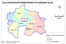
Hungund or Hunagunda is a taluk in the northern district of Bagalkot in Karnataka, India. Major towns in the taluk are Amingad, Hunagunda. Kudalasangama, where the social reformist Basavanna died, is located in the taluk. Hunagunda Taluk also contains Aihole and Pattadkal which were once under the rule of Chalukyas of Badami. Amingad is known for Amingad karadantu, a sweet dish.

Bilagi is a panchayat town and taluka in the Bagalkot district of Karnataka, India. It is located at a distance of 30 km from the district headquarters of Bagalkote. The main occupation of people in this taluka is agriculture. Most of the farmers grow sugarcane.

Guledgudda is a town in the Indian state of Karnataka. It was earlier a part of the Badami taluk, but is now the headquarters of the Guledgudda taluk in Bagalkot district.
Kushtagi is a panchayat town in Koppal district in the Indian state of Karnataka. Kushtagi is a taluk center of Koppal district. This taluk has a population of 353,142 as per the 2021 census estimate. In this taluk, pomegranate fruits are popularly grown.There is a Durga devi temple in heart of the town. To its North lies Ilkal, Gajendragad to the West, Hospet to the South and Sindhanur to the East. Red and black soil can be found in this taluk. A big lake 4kms away from the city is the main source of drinking water is situated in west side and covering the area of more than 300 acres.
Molakalmuru is a taluk in Chitradurga district in the Indian state of Karnataka. It is near the border of Karnataka and Andhra Pradesh. It borders the Rayadurg taluk of Ananthpur district of Andhra Pradesh. Legend has it that its name means "broken knees" in Kannada, referencing a battle between the native Indians and the British in which, due to the rocky and hilly terrain, British soldiers suffered many broken knees in their defeat. The town is famous for the unique Molkalmuru sarees manufactured here.
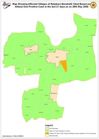
Rabkavi Banhatti is a town situated on the bank of River Krishna. It was declared a taluka by Karnataka State Govt. on 15 March 2017 and it became operational from 01-Jan-2018. It comes under Jamkhandi subdivision. It has a city municipal council in the Bagalkot district of the Indian state of Karnataka. It forms twin city along with Rabakavi, Rampur and Hosur. It is a hub of the textile business for the surrounding districts.

Athani is a town in the Belagavi district of Karnataka, India. It is 140 kilometers from the city of Belagavi, 70 kilometers from Vijayapura, 55 kilometers from Miraj, 100 kilometers from Kolhapur, and 624 kilometers from Bengaluru.

Ilkal sari is a traditional form of sari which is a common feminine wear in India. Ilkal sari takes its name from the town of Ilkal in the Bagalkot district of Karnataka state, India. Ilkal saris are woven using cotton warp on the body and art silk warp for border and art silk warp for pallu portion of the sari. In some cases instead of art silk, pure silk is also used.
Hanamsagar, also spelled as Hanumasagara is a village in the Kushtagi taluk of Koppal district in Karnataka state, India.

Tiruvannamalai district is the second largest district in Tamil Nadu by area after Dindigul District and one of the 38 districts in the state of Tamil Nadu, in South India. It was formed in the year 1989 through the bifurcation of North Arcot into the Tiruvannamalai Sambuvarayar and Vellore Ambedkar districts. The city of Tiruvannamalai is the district headquarters.
Kovai Cora cotton or Kovai Kora cotton is a type of saree made in the Coimbatore region in Tamil Nadu, India. It has been recognized as a Geographical indication by the Government of India in 2014–15. The Devanga community are pioneers in weaving Kovai Kora cotton saris. 82 Weaver cooperative Societies in Coimbatore, Tiruppur and Erode are authorised to sell Kovai Kora cotton saris.

Handloom saris are a traditional textile art of Bangladesh and India. The production of handloom saris is important for economic development in rural India.
Kasavu is a technique used in handlooms of Kerala, with very fine threads of gold or silver used in weave to make border lines and designs on silk and cotton fabrics. This technique later spread to most of India and the Kasav technique was developed for many other fabrics across India. White or off-white cotton cloth with Kasav borders that originated in the South Indian state of Kerala is now famous as Kerala saree is believed to be first form of use of Kasav technique.