Illa Grossa

Last updated • 2 min readFrom Wikipedia, The Free Encyclopedia
Illa Grossa
Illa Grossa.jpg
Illa Grossa with visible lighthouse
Relief Map of Spain.png
Red pog.svg
Illa Grossa
Location in Spain
Geography
Coordinates 39°53′50″N0°41′00″E / 39.89722°N 0.68333°E / 39.89722; 0.68333
Archipelago Columbretes Islands
Adjacent to Mediterranean Sea
Area0.14 km2 (0.054 sq mi)
Administration

Illa Grossa, ("Large Island" in Valencian) [1] [2] is the largest island of the Columbretes archipelago of Spain, located in the Mediterranean Sea. It has a surface area of 14 hectares, or 0.05 square miles. It sits 60 km from Costa del Azahar. [1] The island has experienced a rifting process since the lower Miocene, [3] and is characterized by a significant presence of basalt materials. [4] It is the result of a number of craters forming a chain, and its shape resembles the halve of an ellipse with an average diameter of 1 km, with two main elevations. The island's highest point, located in the northern section, is called mount Colibrí [5] or Colibre. [2] Along with the rest of the islands of the archipelago, it belongs to the Columbretes Islands Natural Reserve.

Contents

History

The island was used as a refuge by pirates and smugglers. [6] In the mid 19th Century, the island was set on fire in order to exterminate the large population of snakes. The snakes were endemic to the islands, and the archipelago's original names (Ophiusa or Columbraria) were given by Greek and Roman sailors due to the abundance of reptiles. In 1859, a lighthouse was built 67 m above sea level, the highest point of the archipelago. In 1895, Ludwig Von Salvator published his book Columbretes, the world's first account of the island's flora and fauna. [7]

The lighthouse was operated by lighthouse keepers until 1975, when it was automated. In the late 1970s, the Spanish and American navies bombarded the islands as part of military exercises. The use of the islands as targets stopped in 1982, after student protests calling for an end of the bombardments pushed the Deputation of Castellón to solicit an end to the exercises, with the Spanish Ministry of Defense complying to the request. The island is uninhabited, except for guards established by the Generalitat Valenciana.

The Columbretes islands were declared a natural park by the Council of the Generalitat Valenciana through the 15/1988 decree of 25 January, [8] and a Marine Reserve of more than 4.400 hectares by the Ministry of Agriculture, Fisheries and Food through the Ministerial Order of 19 April 1990. [9] They were renamed a Natural Reserve by the Generalitat Valenciana through the 11/1994 Law of 27 December. [10]

Fauna

The Columbretes lizard (Podarcis atrata) Sargantana dels Columbrets (Podarcis atrata)1405Columbretes(BV).JPG
The Columbretes lizard (Podarcis atrata)

The island is known for being the natural habitat of the Columbretes lizard ( Podarcis atrata ). [11] The island is also inhabited by animals in danger of extinction, such as Eleonora's falcon [12] and Audouin's gull. [13]

Related Research Articles

<span class="mw-page-title-main">Castellón de la Plana</span> Municipality in Valencian Community, Spain

Castellón de la Plana, or simply Castellón, is the capital city of the province of Castellón, in the Valencian Community, Spain. It is located in the east of the Iberian Peninsula, on the Costa del Azahar by the Mediterranean Sea. The mountain range known as Desert de les Palmes rises inland north of the town.

<span class="mw-page-title-main">Filfla</span> Uninhabited island in Malta

Filfla is a mostly barren, uninhabited islet 4.5 kilometres south of Malta, and is the most southerly point of the Maltese Archipelago. Filflu, a rocky islet some 101 metres southwest of Filfla, has the southernmost point of Malta. The name is believed to come from felfel, the Arabic for a peppercorn.

<span class="mw-page-title-main">Benicàssim</span> Municipality in Valencian Community, Spain

Benicàssim ; officially Benicasim / Benicàssim) is a municipality and beach resort located in the province of Castellón, on the Costa del Azahar in Spain. The Desert de les Palmes mountain range further inland shelters the town from the north wind.

<span class="mw-page-title-main">Alegranza</span> Uninhabited Spanish island in the Atlantic Ocean

Alegranza is an uninhabited island in the Atlantic Ocean, located off the coast of Africa and is in the province of Las Palmas in the Canary Islands, Spain. It is the northernmost point in the Canary Islands, and part of the Chinijo Archipelago. The island is part of the municipality of Teguise on Lanzarote.

<span class="mw-page-title-main">Montgó Massif</span> Mountain in Spain

Montgó is a mountain in Alicante Province, Spain, which rises to 753 metres (2,470 ft). It is the last spur on the Cordillera Prebética Mountain Range and is located in the Marina Alta region in the north of Alicante between the towns of Dénia and Xàbia. The mountain rises dramatically from the valley floors surrounding it and dominates the skyline for miles around. Its craggy cliffs are home to some of the most unusual flora and fauna in Spain. The mountain is renowned for its rock formations, cliffs, caves and natural harbours. From the Xàbia side Montgó is often said to resemble the head and trunk of an elephant. The mountain can be easily reached by highway CV-736 which links Denia with Xàbia, both of which are accessible via the AP-7 motorway or the N-332 national highway.

<span class="mw-page-title-main">Columbretes Islands</span> Islands in Valencia, Spain

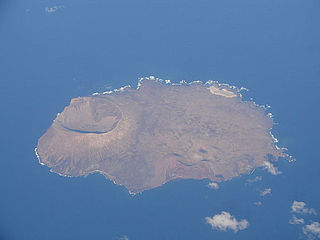
The Columbretes Islands are a group of small uninhabited islets of volcanic origin, in the Mediterranean Sea, 49 kilometres off Oropesa del Mar. Administratively they belong to Castellón de la Plana in the Valencian Community.

<span class="mw-page-title-main">Galite Islands</span> Tunisian archipelago

The Galite Islands are a rocky group of islands of volcanic origin that belong to Bizerte Governorate, northern Tunisia. They are located 38 kilometres northwest of Cape Serrat, the closest point of the Tunisian mainland coast, from which they are separated by the Galite Channel, and almost 80 km (50 mi) north-by-northeast of the city of Tabarka, and 150 km (93 mi) south of Cape Spartivento in the south of Sardinia. The islands of the group sit atop Banc de Galite.

<span class="mw-page-title-main">Lilford's wall lizard</span> Species of lizard

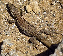
Lilford's wall lizard is a species of lizard in the family Lacertidae. The species is endemic to the Gymnesian Islands, the easternmost of the Balearic Islands, Spain.

<span class="mw-page-title-main">Himne de l'Exposició</span> Anthem of the Valencian Community

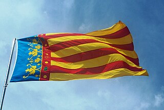
The Himne de l'Exposició or Himne de València is the official anthem of the Valencian Community, Spain. The song was composed by José Serrano Simeón with lyrics written by Maximiliano Thous Orts for the Valencia Regional Exhibition. The music is based on a 16th-century anthem dedicated to Saint George, who was the patron saint of the Kingdom of Valencia. It was approved by the mayors of Alicante, Castellón and Valencia in May 1925, and it was declared as the official anthem of the Valencian Community in 1981, with the approval of the Valencian Statute of Autonomy.

<span class="mw-page-title-main">Valencian Community</span> Autonomous community of Spain

The Valencian Community is an autonomous community of Spain. It is the fourth most populous Spanish autonomous community after Andalusia, Catalonia and the Community of Madrid with more than five million inhabitants. Its homonymous capital Valencia is the third largest city and metropolitan area in Spain. It is located along the Mediterranean coast on the east side of the Iberian Peninsula. It borders Catalonia to the north, Aragon and Castilla–La Mancha to the west, and Murcia to the south, and the Balearic Islands are to its east. The Valencian Community is divided into three provinces: Castellón, Valencia and Alicante.

<span class="mw-page-title-main">Desert de les Palmes Range</span> Mountain range in Spain

Desert de les Palmes, also known as Serra del Desert de les Palmes is an 18.8 km long mountain range in the Plana Alta comarca, Valencian Community, Spain. Its highest point is Bartolo.

<span class="mw-page-title-main">Torreblanca</span> Municipality in Valencian Community, Spain

Torreblanca is a municipality in the province of Castellón, Valencian Community, Spain. The town is located south of the Serra d'Irta mountain range close to the Mediterranean Sea.

<span class="mw-page-title-main">President of the Valencian Government</span> Spanish autonomous community head

The president of the Valencian Government is the head of the Generalitat Valenciana, the government of the Spanish autonomous community of Valencia. The president is chosen by the Valencian parliament, the Corts Valencianes.

<span class="mw-page-title-main">Habibas Islands</span> Islands belonging to Algeria

The Habibas islands35°43′29″N1°8′00″W comprise a small archipelago of two small, rocky islands, Gharbia and Charguia, located about 12 km off the Algerian coast, north-west of Oran. Administratively, they lie within Bou Zedjar municipality in Aïn Témouchent Province, Algeria. The islands and surrounding waters constitute the Iles Habibas Marine Nature Reserve.

<span class="mw-page-title-main">2015 Valencian regional election</span> Regional election in Valencia, Spain

The 2015 Valencian regional election was held on Sunday, 24 May 2015, to elect the 9th Corts of the Valencian Community. All 99 seats in the Corts were up for election. The election was held simultaneously with regional elections in twelve other autonomous communities and local elections all throughout Spain.

<span class="mw-page-title-main">Results breakdown of the 2008 Spanish general election (Congress)</span>

This is the results breakdown of the Congress of Deputies election held in Spain on 9 March 2008. The following tables show detailed results in each of the country's 17 autonomous communities and in the autonomous cities of Ceuta and Melilla, as well as a summary of constituency and regional results.

<span class="mw-page-title-main">Alicante (Corts Valencianes constituency)</span>

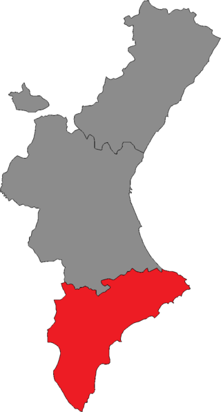
Alicante is one of the three constituencies represented in the Corts Valencianes, the regional legislature of the Valencian Community. The constituency currently elects 35 deputies. Its boundaries correspond to those of the Spanish province of Alicante. The electoral system uses the D'Hondt method and a closed-list proportional representation, with a minimum threshold of five percent regionally.

<span class="mw-page-title-main">Castellón (Corts Valencianes constituency)</span>

Castellón is one of the three constituencies represented in the Corts Valencianes, the regional legislature of the Valencian Community. The constituency currently elects 24 deputies. Its boundaries correspond to those of the Spanish province of Castellón. The electoral system uses the D'Hondt method and a closed-list proportional representation, with a minimum threshold of five percent regionally.

<span class="mw-page-title-main">Valencia (Corts Valencianes constituency)</span>

Valencia is one of the three constituencies represented in the Corts Valencianes, the regional legislature of the Valencian Community. The constituency currently elects 40 deputies. Its boundaries correspond to those of the Spanish province of Valencia. The electoral system uses the D'Hondt method and a closed-list proportional representation, with a minimum threshold of five percent regionally.

<span class="mw-page-title-main">2023 Valencian regional election</span>

The 2023 Valencian regional election was held on Sunday, 28 May 2023, to elect the 11th Corts of the Valencian Community. All 99 seats in the Corts were up for election. The election was held simultaneously with regional elections in eleven other autonomous communities and local elections all throughout Spain.

References

  1. 1 2 "Geological section, Volume 65". Boletín de la Real Sociedad Española de Historia Natural: Órgano del Instituto de Ciencias Naturales José de Acosta. 1967. pp. 27–29.
  2. 1 2 Anuario estadístico de España. Instituto Nacional de Estadística. 1859. p. 67.
  3. Boletín Geológico y Minero. 1991.
  4. "Mar Mediterráneo". VVAA. Empresa Nacional Adaro de Investigaciones Mineras. 1971. p. 209.
  5. Ruis Iñiguez, Ignacio (1935). La tierra y sus aguas ocultas. Reglas para descubrir manantiales (2008 ed.). Valladolid: MAXTOR. p. 101. ISBN   9788497614276.
  6. "Columbretes: el secreto mejor guardado de la costa de Castellón". El Periódico. 28 May 2019. Retrieved 14 July 2020.
  7. "Columbretes: En la cresta del volcán" (PDF). Universitat Jaume I (in Spanish). Archived from the original (PDF) on 27 September 2013. Retrieved 14 July 2020.
  8. "15/1988 Decree of 25 January, of the Council of the Generalitat Valenciana, on the declaration of the Columbretes Islands Natural Park". 29 January 1988. Archived from the original on 23 September 2015. Retrieved 14 July 2020.
  9. "Orden de 19 de abril de 1990 por la que se establece una reserva marina en el entorno de las islas Columbretes". Notícias Jurídicas (in Spanish). Archived from the original on 2020-07-14. Retrieved 2020-07-14.
  10. "Ley 11/1994, de 27 de diciembre, de la Generalitat Valenciana, de espacios naturales protegidos de la Comunidad Valenciana. (DOGV núm. 2423, de 09.01.98)". Generalitat Valenciana. Archived from the original on 2015-09-11. Retrieved 2020-07-14.
  11. Castilla, Aurora M.; Bauwens, Dirk (1991). "Observations on the natural history, present status, and conservation of the insular lizard Podarcis hispanica atrata on the Columbretes archipelago, Spain". Biological Conservation. 58 (1): 69–84. doi:10.1016/0006-3207(91)90045-B.
  12. López-Darias, Maria; Rumeu, Beatriz. "Status and population trend of Eleonora's Falcon Falco eleonorae in the Canary Islands". CiteSeerX   10.1.1.662.2766 .
  13. Castilla, Aurora M. (1995). "Intensive Predation of Artificial Audouin's Gull Nests by the Yellow-Legged Gull in the Columbretes Islands, Spain". Colonial Waterbirds. 18 (2). Waterbird Society: 226–230. doi:10.2307/1521487. JSTOR   1521487.