Ilse valley

Last updated
Ilse river Ilse im Harz nahe Ilsenburg.JPG
Ilse river

The Ilse valley (German : Ilsetal) is the ravine of the Ilse stream in the northern boundary of the Harz mountain range in Germany. Part of the Harz National Park, it runs from the town of Ilsenburg at the foot of the mountain range up to the source region near the summit of the Brocken massif, the highest mountain of the range. The scenic valley is a popular hiking area.

German language West Germanic language

German is a West Germanic language that is mainly spoken in Central Europe. It is the most widely spoken and official or co-official language in Germany, Austria, Switzerland, South Tyrol in Italy, the German-speaking Community of Belgium, and Liechtenstein. It is also one of the three official languages of Luxembourg and a co-official language in the Opole Voivodeship in Poland. The languages which are most similar to German are the other members of the West Germanic language branch: Afrikaans, Dutch, English, the Frisian languages, Low German/Low Saxon, Luxembourgish, and Yiddish. There are also strong similarities in vocabulary with Danish, Norwegian and Swedish, although those belong to the North Germanic group. German is the second most widely spoken Germanic language, after English.

Ilse (Oker) river in Germany

The Ilse is a river of Saxony-Anhalt and Lower Saxony, Germany.

Harz Low mountain range in northern Germany

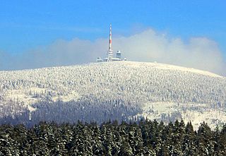
The Harz is a Mittelgebirge that has the highest elevations in Northern Germany and its rugged terrain extends across parts of Lower Saxony, Saxony-Anhalt, and Thuringia. The name Harz derives from the Middle High German word Hardt or Hart, Latinized as Hercynia. The Brocken is the highest summit in the Harz with an elevation of 1,141.1 metres (3,744 ft) above sea level. The Wurmberg is the highest peak located entirely within the state of Lower Saxony.

As one approaches the steep northwestern edge of the Harz, one can see its more prominent peaks. Between Goslar and Wernigerode, the mountains are especially striking, where their slopes rise steeply from the northern foothills. Between the mountains of the Harz rim run deep gorges. These include those of the Ilse river as well as the parallel valleys of the Oker, Ecker and Bode (Bode Gorge).

Goslar Place in Lower Saxony, Germany

Goslar is a historic town in Lower Saxony, Germany. It is the administrative centre of the district of Goslar and located on the northwestern slopes of the Harz mountain range. The Old Town of Goslar and the Mines of Rammelsberg are UNESCO World Heritage Sites.

Wernigerode Place in Saxony-Anhalt, Germany

Wernigerode is a town in the district of Harz, Saxony-Anhalt, Germany. Until 2007, it was the capital of the district of Wernigerode. Its population was 35,041 in 2012.

Oker Sidestream of the river Aller

The Oker is a river in Lower Saxony, Germany, that has historically formed an important political boundary. It is a left tributary of the River Aller, 128 kilometres (80 mi) in length and runs in a generally northerly direction.

Heine memorial tablet Heine-Gedenkstein.jpg
Heine memorial tablet

Heinrich Heine, the famous German writer, described the Ilse valley with its little river and the rocks of the Ilsestein enthroned above it. In the 1830s, a country road was built from Ilsenburg through the Ilse valley running past the Brocken massif up to Schierke, paid for by Count Henry of Stolberg-Wernigerode (1772–1854). The road made it much easier for tourists to reach the higher mountain regions; today it is closed to public traffic.

Heinrich Heine German poet, journalist, essayist, and literary critic

Christian Johann Heinrich Heine was a German poet, journalist, essayist, and literary critic. He is best known outside of Germany for his early lyric poetry, which was set to music in the form of Lieder by composers such as Robert Schumann and Franz Schubert. Heine's later verse and prose are distinguished by their satirical wit and irony. He is considered part of the Young Germany movement. His radical political views led to many of his works being banned by German authorities—which, however, only added to his fame. He spent the last 25 years of his life as an expatriate in Paris.

Ilsestein

The Ilsestein is a prominent granite rock formation near the town of Ilsenburg in the Harz mountains of central Germany. Offering a scenic view over the Ilse valley to the Brocken massif, the highest mountain of the range, it is today a popular tourist destination.

Schierke Stadtteil of Wernigerode in Saxony-Anhalt, Germany

Schierke is a village and a former municipality in the Harz district, in the German state of Saxony-Anhalt. Since 1 July 2009, it is part of the town Wernigerode. Situated within the Harz mountain range in the valley of the Bode River, at the rim of the Harz National Park, it is mainly a tourist resort, especially for hiking and all kinds of winter sport.

The Brocken (1,141 m above NN) can be climbed from Ilsenburg (250 m above NN) via the 'Heinrich Heine Way' and the Plessenburg lodge on a 15 kilometres (9.3 mi) long hiking trail. In or near the Ilse valley are the following checkpoints on the Harzer Wandernadel hiking network (in downstream order with checkpoint numbers in brackets): Gelber Brink (22), Große Zeterklippe (10), Brockenhaus (9), Stempelsbuche (8), Bremer Hütte (6), Gasthaus Ilsestein (30) and Froschfelsen (5). [1]

Plessenburg human settlement in Germany

Plessenburg is a village in the borough of Ilsenburg in the Harz National Park, in the district of Harz in the German state of Saxony-Anhalt.

Harzer Wandernadel

The Harzer Wandernadel is a system of hiking awards in the Harz mountains in central Germany. The hiker can earn awards at different levels of challenge by walking to the various checkpoints in the network and stamping his or her passbook to record the visit. With 222 checkpoints in three federal states and across five districts in the Harz and with membership in five figures, the system has gained a following Germany-wide.

Bremen Hut (Ilsenburg) building

The Bremen Hut in the Harz Mountains is a refuge hut and shelter in that part of the Harz National Park lying within the borough of Ilsenburg (Harz) in Harz district in the German state of Saxony-Anhalt.

Related Research Articles

Harz National Park national park of Germany

Harz National Park is a nature reserve in the German federal states of Lower Saxony and Saxony-Anhalt. It comprises portions of the western Harz mountain range, extending from Herzberg and Bad Lauterberg at the southern edge to Bad Harzburg and Ilsenburg on the northern slopes. 95 % of the area is covered with forests, mainly with spruce and beech woods, including several bogs, granite rocks and creeks. The park is part of the Natura 2000 network of the European Union.

Brocken Harz mountain in Germany

The Brocken, also sometimes referred to as the Blocksberg, is the highest peak of the Harz mountain range and also the highest peak of Northern Germany; it is located near Schierke in the German state of Saxony-Anhalt between the rivers Weser and Elbe. Although its elevation of 1,141 metres (3,743 ft) is below alpine dimensions, its microclimate resembles that of mountains of about 2,000 m (6,600 ft). The peak above the tree line tends to have a snow cover from September to May, and mists and fogs shroud it up to 300 days of the year. The mean annual temperature is only 2.9 °C (37.2 °F). It is the easternmost mountain in northern Germany; travelling east in a straight line, the next prominent elevation would be in the Ural Mountains in Russia.

Ilsenburg Place in Saxony-Anhalt, Germany

Ilsenburg is a town in the district of Harz, in Saxony-Anhalt in Germany. It is situated under the north foot of the Harz Mountains, at the entrance to the Ilse valley with its little river, the Ilse, a tributary of the Oker, about six 6 miles (9.7 km) north-west of the town of Wernigerode. It received town privileges in 1959. Owing to its surrounding of forests and mountains as well as its position on the edge of the Harz National Park, Ilsenburg is a popular tourist resort.

Elend, Saxony-Anhalt Stadtteil of Oberharz am Brocken in Saxony-Anhalt, Germany

Elend is a district of the town of Oberharz am Brocken in the Harz District, in Saxony-Anhalt, Germany. It lies in the Bode valley in the High Harz in central Germany, at a height of 505 m above NN. This part of the valley is known locally as Elendstal. Elend is located near the former Inner German Border between West and East Germany.

Hohnekamm mountain

The Hohnekamm or Hohne Kamm is a mountain ridge up to 900 m above sea level high in the Harz mountains of central Germany. It is located in the state of Saxony-Anhalt, and is well known for its rock towers or tors, the Hohneklippen.

Hoher Kleef

The Hoher Kleef is a rock formation in Rübeland in the district of Harz within the Harz mountains of Germany. It is mainly composed of granite.

The Taubenklippe is a rock formation in the Harz mountains in the German state of Saxony-Anhalt. It lies about halfway between Bad Harzburg and Ilsenburg at a height of 572 m above NN on the eastern slopes of the Ecker valley. From the crag there is a good view over Harz Foreland, the heights near Bad Harzburg and the highest mountain in the Har, the Brocken. The Taubenklippe may be reached from the Ecker valley on a footpath, some 6 km long, that starts in Ilsenburg.

Renneckenberg mountain in Germany

The Renneckenberg is a mountain, roughly 933 metres (3,061 ft) high, in the High Harz part of the Harz mountain range of central Germany within the borough of Wernigerode in the state of Saxony-Anhalt.

Froschfelsen

The Froschfelsen, also called the Froschsteinklippe, is a natural monument near Ilsenburg in the northern Harz in central Germany. It is a formation of granite rocks that take the shape of a frog, hence the name.

The Molkenhaus is a historic house near Wernigerode, Harz, Germany, located on the Jägerkopf hill above the Steinerne Renne waterfall and the source region of the Holtemme river. The timber-framed building, which was built by order of the Senior Master Hunter (Oberjägermeister) of the counts of Stolberg, von Meseberg, at the beginning of the 18th century, belonged to the Ilsenburger Marienhof and was used for hunting purposes and the production of butter. Nowadays it is used by the Harz National Park.

The Eckerloch is a forested mountain valley, 845 metres above sea level near the village of Schierke in the Harz Mountains of central Germany.

Scharfenstein (Ilsenburg) mountain

The Scharfenstein is a mountain, 697.6 m above sea level (NN) high, in the Harz Mountains of Germany, near Ilsenburg in the district of Harz in Saxony-Anhalt. It is part of the Harz National Park.

The Ahrensklint or Ahrentsklint in the Harz Mountains is a granite rock formation, 822.4 m above sea level (NN), on the Erdbeerkopf in Harz district in the German state of Saxony-Anhalt.

Barenberg (Schierke) mountain in the Harz, Germany

The Barenberg, also called the Bärenberg or Bärenkopf, is a mountain, 695.5 m above sea level (NN), in the Harz Mountains of Germany near the village of Schierke, Harz county, in the state of Saxony-Anhalt.

Kapitelsberg mountain in Germany

The Kapitelsberg in the Harz Mountains of Germany is a hill, 535.7 m above sea level (NN), near the village of Tanne in the county of Harz, Saxony-Anhalt.

Elversstein

The Elversstein in the Harz Mountains of Germany is a granite rock formation with a maximum elevation of 499 m above sea level (NN) on the Steinberg near Hasserode in the county of Harz in Saxony-Anhalt.

References

  1. Harzer Wandernadel: Das Wanderstempeln im Harz - Übersichtstabelle at www.harzer-wandernadel.de. Retrieved 20 Jun 2019.

Coordinates: 51°51′01″N10°39′58″E / 51.85028°N 10.66611°E / 51.85028; 10.66611

Geographic coordinate system Coordinate system

A geographic coordinate system is a coordinate system that enables every location on Earth to be specified by a set of numbers, letters or symbols. The coordinates are often chosen such that one of the numbers represents a vertical position and two or three of the numbers represent a horizontal position; alternatively, a geographic position may be expressed in a combined three-dimensional Cartesian vector. A common choice of coordinates is latitude, longitude and elevation. To specify a location on a plane requires a map projection.