Imaging radar is an application of radar which is used to create two-dimensional images, typically of landscapes. Imaging radar provides its light to illuminate an area on the ground and take a picture at radio wavelengths. It uses an antenna and digital computer storage to record its images. In a radar image, one can see only the energy that was reflected back towards the radar antenna. The radar moves along a flight path and the area illuminated by the radar, or footprint, is moved along the surface in a swath, building the image as it does so. [1]
Digital radar images are composed of many dots. Each pixel in the radar image represents the radar backscatter for that area on the ground (terrain return): brighter areas represent high backscatter, darker areas represents low backscatter. [1]
The traditional application of radar is to display the position and motion of typically highly reflective objects (such as aircraft or ships) by sending out a radiowave signal, and then detecting the direction and delay of the reflected signal. Imaging radar on the other hand attempts to form an image of one object (e.g. a landscape) by furthermore registering the intensity of the reflected signal to determine the amount of scattering. The registered electromagnetic scattering is then mapped onto a two-dimensional plane, with points with a higher reflectivity getting assigned usually a brighter color, thus creating an image.
Several techniques have evolved to do this. Generally they take advantage of the Doppler effect caused by the rotation or other motion of the object and by the changing view of the object brought about by the relative motion between the object and the back-scatter that is perceived by the radar of the object (typically, a plane) flying over the earth. Through recent improvements of the techniques, radar imaging is getting more accurate. Imaging radar has been used to map the Earth, other planets, asteroids, other celestial objects and to categorize targets for military systems.
An imaging radar is a kind of radar equipment which can be used for imaging. A typical radar technology includes emitting radio waves, receiving their reflection, and using this information to generate data. For an imaging radar, the returning waves are used to create an image. When the radio waves reflect off objects, this will make some changes in the radio waves and can provide data about the objects, including how far the waves traveled and what kind of objects they encountered. Using the acquired data, a computer can create a 3-D or 2-D image of the target. [2]
Imaging radar has several advantages. [3] It can operate in the presence of obstacles that obscure the target, and can penetrate ground (sand), water, or walls. [4] [5]
Time-Frequency Domain techniques are essential in imaging radar to analyze and process signals that vary in both time and frequency. Radar signals are often non-stationary due to moving targets or environmental changes. Time-Frequency Domain techniques provide insights into how signal characteristics (e.g., frequency) evolve over time, enabling better understanding and extraction of target information.
Common Methods for Time-Frequency Analysis:
Method | Principle | Strengths | Limitations |
---|---|---|---|
Short-time Fourier transform | Decomposes the radar signal into time-localized frequency components using short overlapping windows. | Easy to implement and interpret. | Trade-off between time and frequency resolution. |
Wavelet Transform | Uses wavelet functions to decompose radar signals into time-scale (frequency) representations. | Multi-resolution capability; suitable for non-stationary signals. | Requires careful selection of wavelet basis. |
Hilbert-Huang Transform | Decomposes signals into Intrinsic Mode Functions (IMFs) for instantaneous frequency analysis. | Well-suited for non-linear, non-stationary radar signals. | Computationally intensive and sensitive to noise. |
Wigner distribution function | Provides high-resolution time-frequency representation by analyzing signal energy distribution. | High resolution in both time and frequency domains. | Prone to cross-term interference in multi-component signals. |
Applications include: surface topography & coastal change; land use monitoring, agricultural monitoring, ice patrol, environmental monitoring;weather radar- storm monitoring, wind shear warning;medical microwave tomography; [5] through wall radar imaging; [6] 3-D measurements, [7] etc.
Wall parameter estimation uses Ultra Wide-Band radar systems. The handle M-sequence UWB radar with horn and circular antennas was used for data gathering and supporting the scanning method. [6]
3-D measurements are supplied by amplitude-modulated laser radars—Erim sensor and Perceptron sensor. In terms of speed and reliability for median-range operations, 3-D measurements have superior performance. [7]
Current radar imaging techniques rely mainly on synthetic aperture radar (SAR) and inverse synthetic aperture radar (ISAR) imaging. Emerging technology utilizes monopulse radar 3-D imaging.
Real aperture radar (RAR) is a form of radar that transmits a narrow angle beam of pulse radio wave in the range direction at right angles to the flight direction and receives the backscattering from the targets which will be transformed to a radar image from the received signals.
Usually the reflected pulse will be arranged in the order of return time from the targets, which corresponds to the range direction scanning.
The resolution in the range direction depends on the pulse width. The resolution in the azimuth direction is identical to the multiplication of beam width and the distance to a target. [8]
The AVTIS radar is a 94 GHz real aperture 3D imaging radar. It uses Frequency-Modulated Continuous-Wave modulation and employs a mechanically scanned monostatic with sub-metre range resolution. [9]
Laser radar is a remote sensing technology that measures distance by illuminating a target with a laser and analyzing the reflected light. [10]
Laser radar is used for multi-dimensional imaging and information gathering. In all information gathering modes, lasers that transmit in the eye-safe region are required as well as sensitive receivers at these wavelengths. [11]
3-D imaging requires the capacity to measure the range to the first scatter within every pixel. Hence, an array of range counters is needed. A monolithic approach to an array of range counters is being developed. This technology must be coupled with highly sensitive detectors of eye-safe wavelengths. [11]
To measure Doppler information requires a different type of detection scheme than is used for spatial imaging. The returned laser energy must be mixed with a local oscillator in a heterodyne system to allow extraction of the Doppler shift. [11]
Synthetic-aperture radar (SAR) is a form of radar which moves a real aperture or antenna through a series of positions along the objects to provide distinctive long-term coherent-signal variations. This can be used to obtain higher resolution.
SARs produce a two-dimensional (2-D) image. One dimension in the image is called range and is a measure of the "line-of-sight" distance from the radar to the object. Range is determined by measuring the time from transmission of a pulse to receiving the echo from a target. Also, range resolution is determined by the transmitted pulse width. The other dimension is called azimuth and is perpendicular to range. The ability of SAR to produce relatively fine azimuth resolution makes it different from other radars. To obtain fine azimuth resolution, a physically large antenna is needed to focus the transmitted and received energy into a sharp beam. The sharpness of the beam defines the azimuth resolution. An airborne radar could collect data while flying this distance and process the data as if it came from a physically long antenna. The distance the aircraft flies in synthesizing the antenna is known as the synthetic aperture. A narrow synthetic beam width results from the relatively long synthetic aperture, which gets finer resolution than a smaller physical antenna. [12]
Inverse synthetic aperture radar (ISAR) is another kind of SAR system which can produce high-resolution on two- and three-dimensional images.
An ISAR system consists of a stationary radar antenna and a target scene that is undergoing some motion. ISAR is theoretically equivalent to SAR in that high-azimuth resolution is achieved via relative motion between the sensor and object, yet the ISAR moving target scene is usually made up of non cooperative objects.
Algorithms with more complex schemes for motion error correction are needed for ISAR imaging than those needed in SAR. ISAR technology uses the movement of the target rather than the emitter to make the synthetic aperture. ISAR radars are commonly used on vessels or aircraft and can provide a radar image of sufficient quality for target recognition. The ISAR image is often adequate to discriminate between various missiles, military aircraft, and civilian aircraft. [13]
Rolling is side to side. Pitching is forward and backwards, yawing is turning left or right.
Monopulse radar 3-D imaging technique uses 1-D range image and monopulse angle measurement to get the real coordinates of each scatterer. Using this technique, the image doesn't vary with the change of the target's movement. Monopulse radar 3-D imaging utilizes the ISAR techniques to separate scatterers in the Doppler domain and perform monopulse angle measurement.
Monopulse radar 3-D imaging can obtain the 3 views of 3-D objects by using any two of the three parameters obtained from the azimuth difference beam, elevation difference beam and range measurement, which means the views of front, top and side can be azimuth-elevation, azimuth-range and elevation-range, respectively.
Monopulse imaging generally adapts to near-range targets, and the image obtained by monopulse radar 3-D imaging is the physical image which is consistent with the real size of the object. [14]
This article may have been created or edited in return for undisclosed payments, a violation of Wikipedia's terms of use. It may require cleanup to comply with Wikipedia's content policies, particularly neutral point of view. (May 2021) |
4D imaging radar leverages a Multiple Input Multiple Output (MiMo) antenna array for high-resolution detection, mapping and tracking of multiple static and dynamic targets simultaneously. It combines 3D imaging with Doppler analysis to create the additional dimension – velocity. [15]
A 4D imaging radar system measures the time of flight from each transmitting (Tx) antenna to a target and back to each receiving (Rx) antenna, processing data from the numerous ellipsoids formed. The point at which the ellipsoids intersect – known as a hot spot - reveals the exact position of a target at any given moment.
Its versatility and reliability make 4D imaging radar ideal for smart home, automotive, retail, security, healthcare and many other environments. The technology is valued for combining all the benefits of camera, LIDAR, thermal imaging and ultrasonic technologies, with additional benefits:
Radar is a system that uses radio waves to determine the distance (ranging), direction, and radial velocity of objects relative to the site. It is a radiodetermination method used to detect and track aircraft, ships, spacecraft, guided missiles, motor vehicles, map weather formations, and terrain.
Synthetic-aperture radar (SAR) is a form of radar that is used to create two-dimensional images or three-dimensional reconstructions of objects, such as landscapes. SAR uses the motion of the radar antenna over a target region to provide finer spatial resolution than conventional stationary beam-scanning radars. SAR is typically mounted on a moving platform, such as an aircraft or spacecraft, and has its origins in an advanced form of side looking airborne radar (SLAR). The distance the SAR device travels over a target during the period when the target scene is illuminated creates the large synthetic antenna aperture. Typically, the larger the aperture, the higher the image resolution will be, regardless of whether the aperture is physical or synthetic – this allows SAR to create high-resolution images with comparatively small physical antennas. For a fixed antenna size and orientation, objects which are further away remain illuminated longer – therefore SAR has the property of creating larger synthetic apertures for more distant objects, which results in a consistent spatial resolution over a range of viewing distances.
Aperture synthesis or synthesis imaging is a type of interferometry that mixes signals from a collection of telescopes to produce images having the same angular resolution as an instrument the size of the entire collection. At each separation and orientation, the lobe-pattern of the interferometer produces an output which is one component of the Fourier transform of the spatial distribution of the brightness of the observed object. The image of the source is produced from these measurements. Astronomical interferometers are commonly used for high-resolution optical, infrared, submillimetre and radio astronomy observations. For example, the Event Horizon Telescope project derived the first image of a black hole using aperture synthesis.
A pulse-Doppler radar is a radar system that determines the range to a target using pulse-timing techniques, and uses the Doppler effect of the returned signal to determine the target object's velocity. It combines the features of pulse radars and continuous-wave radars, which were formerly separate due to the complexity of the electronics.
Continuous-wave radar is a type of radar system where a known stable frequency continuous wave radio energy is transmitted and then received from any reflecting objects. Individual objects can be detected using the Doppler effect, which causes the received signal to have a different frequency from the transmitted signal, allowing it to be detected by filtering out the transmitted frequency.
Inverse synthetic-aperture radar (ISAR) is a radar technique using radar imaging to generate a two-dimensional high resolution image of a target. It is analogous to conventional SAR, except that ISAR technology uses the movement of the target rather than the emitter to create the synthetic aperture. ISAR radars have a significant role aboard maritime patrol aircraft to provide them with radar image of sufficient quality to allow it to be used for target recognition purposes. In situations where other radars display only a single unidentifiable bright moving pixel, the ISAR image is often adequate to discriminate between various missiles, military aircraft, and civilian aircraft.
Monopulse radar is a radar system that uses additional encoding of the radio signal to provide accurate directional information. The name refers to its ability to extract range and direction from a single signal pulse.
The AN/APG-76 radar is a pulse Doppler Ku band multi-mode radar developed and manufactured by Northrop Grumman.
Interferometric synthetic aperture radar, abbreviated InSAR, is a radar technique used in geodesy and remote sensing. This geodetic method uses two or more synthetic aperture radar (SAR) images to generate maps of surface deformation or digital elevation, using differences in the phase of the waves returning to the satellite or aircraft. The technique can potentially measure millimetre-scale changes in deformation over spans of days to years. It has applications for geophysical monitoring of natural hazards, for example earthquakes, volcanoes and landslides, and in structural engineering, in particular monitoring of subsidence and structural stability.
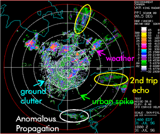
Clutter is the unwanted return (echoes) in electronic systems, particularly in reference to radars. Such echoes are typically returned from ground, sea, rain, animals/insects, chaff and atmospheric turbulences, and can cause serious performance issues with radar systems. What one person considers to be unwanted clutter, another may consider to be a wanted target. However, targets usually refer to point scatterers and clutter to extended scatterers. The clutter may fill a volume or be confined to a surface. A knowledge of the volume or surface area illuminated is required to estimated the echo per unit volume, η, or echo per unit surface area, σ°.
The AN/FPS-16 is a highly accurate ground-based monopulse single object tracking radar (SOTR), used extensively by the NASA crewed space program, the U.S. Air Force and the U.S. Army. The accuracy of Radar Set AN/FPS-16 is such that the position data obtained from point-source targets has azimuth and elevation angular errors of less than 0.1 milliradian and range errors of less than 5 yards (5 m) with a signal-to-noise ratio of 20 decibels or greater.
Radar engineering is the design of technical aspects pertaining to the components of a radar and their ability to detect the return energy from moving scatterers — determining an object's position or obstruction in the environment. This includes field of view in terms of solid angle and maximum unambiguous range and velocity, as well as angular, range and velocity resolution. Radar sensors are classified by application, architecture, radar mode, platform, and propagation window.
Radar MASINT is a subdiscipline of measurement and signature intelligence (MASINT) and refers to intelligence gathering activities that bring together disparate elements that do not fit within the definitions of signals intelligence (SIGINT), imagery intelligence (IMINT), or human intelligence (HUMINT).
Wave radar is a type of radar for measuring wind waves. Several instruments based on a variety of different concepts and techniques are available, and these are all often called. This article, gives a brief description of the most common ground-based radar remote sensing techniques.
Moving target indication (MTI) is a mode of operation of a radar to discriminate a target against the clutter. It describes a variety of techniques used for finding moving objects, like an aircraft, and filter out unmoving ones, like hills or trees. It contrasts with the modern stationary target indication (STI) technique, which uses details of the signal to directly determine the mechanical properties of the reflecting objects and thereby find targets whether they are moving or not.
Speckle, speckle pattern, or speckle noise designates the granular structure observed in coherent light, resulting from random interference. Speckle patterns are used in a wide range of metrology techniques, as they generally allow high sensitivity and simple setups. They can also be a limiting factor in imaging systems, such as radar, synthetic aperture radar (SAR), medical ultrasound and optical coherence tomography. Speckle is not external noise; rather, it is an inherent fluctuation in diffuse reflections, because the scatterers are not identical for each cell, and the coherent illumination wave is highly sensitive to small variations in phase changes.
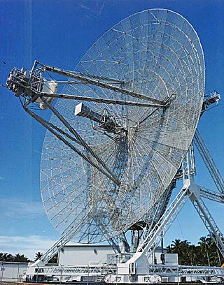
The Tracking & Imaging Radar (TIRA) system serves as the central experimental facility for the development and investigation of radar techniques for the detection and reconnaissance of objects in space, and of air targets.
Atmospheric lidar is a class of instruments that uses laser light to study atmospheric properties from the ground up to the top of the atmosphere. Such instruments have been used to study, among other, atmospheric gases, aerosols, clouds, and temperature.
High Resolution Wide Swath (HRWS) imaging is an important branch in synthetic aperture radar (SAR) imaging, a remote sensing technique capable of providing high resolution images independent of weather conditions and sunlight illumination. This makes SAR very attractive for the systematic observation of dynamic processes on the Earth's surface, which is useful for environmental monitoring, earth resource mapping and military systems.
The history of synthetic-aperture radar begins in 1951, with the invention of the technology by mathematician Carl A. Wiley, and its development in the following decade. Initially developed for military use, the technology has since been applied in the field of planetary science.
{{cite web}}
: Cite uses generic title (help)