Incomappleux River

Last updated
Incomappleux River
Interior Rainforest (4495547683).jpg
Incomappleux inland rainforest
Canada British Columbia relief location map.jpg
Red pog.svg
Location in British Columbia
Location
CountryCanada
ProvinceBritish Columbia
District Kootenay Land District
Physical characteristics
SourceIllecillewaet Neve
  location Selkirk Mountains
Mouth Columbia River
  location
Upper Arrow Lake
  coordinates
50°44′48″N117°42′47″W / 50.74667°N 117.71306°W / 50.74667; -117.71306 [1]
Basin size1,020 km2 (390 sq mi) [2]
Discharge 
  locationnear Beaton [2]
  average55.8 m3/s (1,970 cu ft/s) [2]
  minimum4.76 m3/s (168 cu ft/s)
  maximum570 m3/s (20,000 cu ft/s)
Basin features
ProgressionIncomappleux Valley

The Incomappleux River is in the West Kootenay region of southeastern British Columbia, Canada. Entering the Beaton Arm of Upper Arrow Lake, the river is a major tributary of the Columbia River. The upper reaches of the Incomappleux valley are home to some of the only inland temperate rainforest in the world.

Contents

The area has been studied since 2000 by Valhalla Wilderness Society as a part of their Inland Temperate Rainforest campaign, and the upper Incomappleux was included in the Selkirk Mountain Caribou Park proposal after groundbreaking biodiversity research by biologists Toby Spribille and Curtis Björk, sponsored by Valhalla Wilderness Society, found over 300 species of lichens in the Incomappleux, most of them in the ancient forest. This included seven species new to science. The Incomappleux Valley has been the subject of two films, one by Riel Marquardt, and more recently the VWS film Primeval: Enter the Incomappleux, by award winning documentary filmmaker, Damien Gillis. VWS Director Craig Pettitt and biologist Amber Peters toured the province with the film. The Incomappleux Valley was declared a conservancy in 2023 but the remainder of the Selkirk Mountain Caribou Park proposal, containing critical old growth inland rainforest corridors still remains unprotected. The valley is in the traditional territory of the Sinixt First Nation and its protection was supported by the autonomous Sinixt.

First Nations

The name "Incomappleux" is derived from the Sinixt word nk'mapeleqs, meaning "point at end (of lake)". This refers to the northeastern tip of Upper Arrow Lake into which the river empties. The names of the creek and adjacent mountain are also derived from this word. A Sinixt village by this name formerly existed somewhere in the confluence area. [3]

European presence

Europeans referred to the valley and river by various English spellings of the word, but Fish Creek/River was also common. [3] However, local lore has it that the word is a corruption of the Sinix't word for Fish. [4] In 1865, James Turnbull, surveyor and mapmaker, explored the Incomappleux Valley. [3] After the mid-1880s, visitors could enter the valley from the Canadian Pacific Railway (CP) main line, moving southward through the Glacier National Park area into the valley and following the river to its mouth, but this involved a long climb up and over a high mountain and a long trek down to the river. [5] In 1889, the report of the Gold Commissioner at Farwell reported, "By 1889, ten locations [staked mine sites] had been made on the Northeast area of Upper Arrow Lake. Several claims, including the Fish Creek mines, had been worked on the upper reaches of Incomappleux river..."

Beatrice Mine buildings above the town of Camborne in the Incomappleux River valley, B.C. Incomappleux Rev-Museum Beatrice Mine, 1974 by Lee Harding.jpg
Beatrice Mine buildings above the town of Camborne in the Incomappleux River valley, B.C.
Battle Range viewed from the left (west) side of the Incomappleux River valley, looking north, 1996. Glacier National Park is beyond the Battle Range. Incomappleux Fish-R(c)LeeHarding Battle Range-DeNoiseAI.jpg
Battle Range viewed from the left (west) side of the Incomappleux River valley, looking north, 1996. Glacier National Park is beyond the Battle Range.

The area around Roger's Pass was surveyed by Arthur O. Wheeler in 1902, using a photographic triangulation method that involved setting up a heavy camera on a tripod on a mountain peak and photographing all the other peaks within sight; and doing this again for all the peaks in the survey area. This survey provided the first topographic maps of Glacier National Park, the Battle Range that borders the park on the south, and the area of the upper Incomappleux River valley. [6]

Access was from the south end through a deep, narrow, steep-sided gorge where the miners built a roadway about 0.5 km long out of timbers perched on the side of the cliff and anchored into rock crevices. In winter, horses pulling wagons were fitted with snowshoes for the deep snow. The timber/plank road was still in place and drivable in 1970, although some of the timber supports had fallen away, planks were broken and a sign warned, "ROAD CLOSED". In 1974, Celgar, the logging company based in Nakusp, blasted a solid road through the gorge, destroying the old timber/plank road.

Mines

From the 1890s, mining claims staked upstream (removed from the mouth) were along Pool Creek at 10 kilometres (6 mi), [7] Sable Creek at 18 kilometres (11 mi), and Boyd Creek at 26 kilometres (16 mi). Although most claims were accessed from the south, the Dunvegan group, at the headwaters of the river, [8] was reached by a 16-kilometre (10 mi) trail from the CP station at Albert Canyon. [9]

Ore concentrator building at Camborne, 1973. Incomappleux 3Rev-Museum Concentrator at Camborne, circa 1974 by Lee Harding.jpg
Ore concentrator building at Camborne, 1973.

The town of Camborne was built in 1902 in the lower valley, just upstream from the gorge, to service the mines. The principal mine was the Beatrice Mine, about 9.7 km up a steep trail from the town. Its owners built an ore concentrator at the upper end of the town site; horse-drawn ore carts would dump their loads into a sort of chute at the last switchback above the concentrator. The town was occupied until about 1954. [10]

Nearby towns were Beaton on the Northeast Arm, just below the mouth of the Incomapplex; Galena Bay on the main lake to the south; and Trout Lake, over Galena Pass to the northeast, in the Lardeau River valley.

Source

Formed in the Selkirk Mountains southeast of Glacier, [11] the Illecillewaet Glacier near Rogers Pass is the source of the Illecillewaet River on the northwestern slope. However, the Illecillewaet Neve, which feeds the glacier, primarily flows south into the Incomappleux River. [12]

Course

Incomappleux River valley looking downriver; Boyd Creek entering from the left. 1974. Incomappleux Boyd Cr.jpg
Incomappleux River valley looking downriver; Boyd Creek entering from the left. 1974.

The Incomappleux is about 68 kilometres (42 mi) long, [11] with four large tributaries flowing 19 to 32 kilometres (12 to 20 mi). [8] Following a due south course, the swift, unnavigable river is 9 to 15 metres (30 to 50 ft) wide. [11] Around 61 metres (200 ft) high, [8] the narrow canyon, which is about 5 kilometres (3 mi) from the mouth, funnels the glacial waters. Above the canyon, the valley widens to as much as 2 kilometres (1 mi). [5]

Forestry

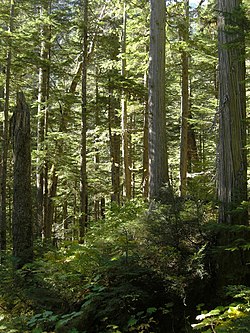
The valley is heavily timbered and unsuited to agriculture. [11] This inland temperate rainforest comprises a wide range of cottonwood and spruce. The accessible conifer-dominated forest has been largely harvested over the decades. [13] Active logging returned in 1974, but environmental protests have restricted harvesting since the early 2000s. [14] In 2022, a moratorium was placed upon logging for at least two years. [15]

Incomappleux Inland Rainforest, BC, 2010. Rainforest Panorama (4496188170).jpg
Incomappleux Inland Rainforest, BC, 2010.

Ferries and bridges across the river

In 1892, a 76-metre (250 ft) bridge existed at the river mouth, and a 14-metre (46 ft) one 32 kilometres (20 mi) upstream near McDougal Creek. [16] [17] After the one at the mouth connecting to Lardeau City was washed out, a temporary 5-by-12-metre (18 by 40 ft) cable ferry commenced in June 1893. [18] [19] A replacement bridge destroyed by the 1894 flood [20] was in turn replaced. [21] A ferry was built in summer 1896, but its placement is unclear. [22]

The lower bridge provided a connection in 1898, [23] when the wagon road up the west side of the river was completed as far as the Camborne ferry. [24] That year, a ferry was installed across the river at Boyd Creek, which could carry six loaded packhorses. [25] [26]

In 1904, the wagon road was extended up the west side of the river from Camborne, and a bridge replaced the ferry at Boyd Creek. [27] [28] At the 12-mile point, a wagon road bridge existed in the 1910s. [29] The only remaining bridge, 2.4 kilometres (1.5 mi) north of Camborne, was a wooden timber bridge that had washed out by 1971. Celgar, the logging company based in Nakusp, built a steel bridge in the same place in 1974. [30]

Conservation

The 58,000 hectare Incomappleux Valley conservancy was established by the provincial government in January of 2023. [31] Conservancies are a class of protected areas in the province that allow some low-impact commercial and industrial uses, but prohibit activities such as large scale logging and road construction. [31]

Incomappleux River from the (then) new steel bridge a little upstream from Camborne, about 1975 1976-maybe-004 025.jpg
Incomappleux River from the (then) new steel bridge a little upstream from Camborne, about 1975

Maps

Discharge

Daily discharge tables 1914–1996 for the 1,020-square-kilometre (390 sq mi) basin. [32]

See also

Related Research Articles

<span class="mw-page-title-main">Rogers Pass (British Columbia)</span> Mountain pass in Canada

Rogers Pass is a high mountain pass through the Selkirk Mountains of British Columbia, but the term also includes the approaches used by the Canadian Pacific Railway (CP) and the Trans-Canada Highway. In the heart of Glacier National Park, this National Historic Site has been a tourist destination since 1886.

The Village of Nakusp is located south of the mouth of Kuskanax Creek, on the Upper Arrow Lake in the West Kootenay region of southeastern British Columbia. Lying between the Selkirk and Monashee ranges, the village is known for its nearby hot springs and picturesque mountain lakeside setting.

The Columbia and Kootenay Railway (C&KR) was a historic railway operated by the Canadian Pacific Railway (CPR) in the West Kootenay region of British Columbia. This 25-mile (40 km) route, beside the unnavigable Kootenay River, linked Nelson on the west arm of Kootenay Lake with Robson at the confluence of the Kootenay River and the Columbia River near Castlegar.

The Nakusp and Slocan Railway (N&S) is a historic Canadian railway that operated in the West Kootenay region of southeastern British Columbia. The N&S initially connected Nakusp and Three Forks but soon extended to Sandon.

<span class="mw-page-title-main">Arrow Lakes</span> Lakes in British Columbia, Canada

The Arrow Lakes in British Columbia, Canada, divided into Upper Arrow Lake and Lower Arrow Lake, are widenings of the Columbia River. The lakes are situated between the Selkirk Mountains to the east and the Monashee Mountains to the west. Beachland is fairly rare, and is interspersed with rocky headlands and steep cliffs. Mountain sides are heavily forested, and rise sharply to elevations around 2,600 metres.

<span class="mw-page-title-main">Illecillewaet River</span> River in British Columbia, Canada

The Illecillewaet River is a tributary of the Columbia River located in British Columbia, Canada. Fed by the Illecillewaet Glacier in Glacier National Park, the river flows approximately 62 kilometres (39 mi) to the southwest, where it flows into the north end of Upper Arrow Lake at Revelstoke. The river's drainage basin is 1,202 square kilometres (464 sq mi).

<span class="mw-page-title-main">Trout Lake (British Columbia)</span> Ribbon lake in British Columbia

Trout Lake is a ribbon lake in the West Kootenay region of southeastern British Columbia. Between the Selkirk Mountains to the west and the Purcell Mountains to the east, the lake is about 23 kilometres (14 mi) long and 1.6 kilometres (1 mi) wide. Lardeau Creek flows into the northern end and Lardeau River flows from the southern end. BC Highway 31 skirts the northeast shore. The northern end is about 90 kilometres (56 mi) by road and ferry southeast of Revelstoke.

Silverton is a village about 5 kilometres (3 mi) south of New Denver in the West Kootenay region of southeastern British Columbia. The former steamboat landing is at the mouth of Silverton Creek on the eastern shore of Slocan Lake. The locality, on BC Highway 6 at the junction of BC Highway 31A, is about 95 kilometres (59 mi) by road north of Castlegar and 155 kilometres (96 mi) by road and ferry south of Revelstoke.

<span class="mw-page-title-main">Slocan, British Columbia</span> Village in British Columbia, Canada

The Village of Slocan is in the West Kootenay region of southeastern British Columbia. The former steamboat landing and ferry terminal is at the mouth of Springer Creek, at the foot of Slocan Lake. The locality, on BC Highway 6 is about 69 kilometres (43 mi) by road north of Castlegar and 183 kilometres (114 mi) by road and ferry south of Revelstoke.

<span class="mw-page-title-main">Steamboats of the Arrow Lakes</span>

The era of steamboats on the Arrow Lakes and adjoining reaches of the Columbia River is long-gone but was an important part of the history of the West Kootenay and Columbia Country regions of British Columbia Canada. The Arrow Lakes are formed by the Columbia River in southeastern British Columbia. Steamboats were employed on both sides of the border in the upper reaches of the Columbia, linking port towns on either side of the border, and sometimes boats would be built in one country and operated in the other. Tributaries of the Columbia include the Kootenay River which rises in Canada, then flows south into the United States, then bends north again back into Canada, where it widens into Kootenay Lake. As with the Arrow Lakes, steamboats once operated on the Kootenay River and Kootenay Lake.

<span class="mw-page-title-main">Glacier, British Columbia</span> Settlement in British Columbia, Canada

Glacier, which once comprised small communities, is on the western approach to Rogers Pass in southeastern British Columbia. The name derives from the Great Glacier, which in the 1880s was just over a mile from the original train station.

The Duncan River is in the West Kootenay region of southeastern British Columbia. Entering the North Arm of Kootenay Lake, the river is a major tributary of the Kootenay River, which in turn flows into the Columbia River. The Selkirk Mountains lie to the west and the Purcell Mountains to the east.

<span class="mw-page-title-main">Albert Canyon</span> Railway point in British Columbia, Canada

Albert Canyon is a railway point in the West Kootenay region of southeastern British Columbia. The community was immediately east of the mouth of Albert Creek on the south shore of the Illecillewaet River. That settlement no longer exists, but the Canyon Hot Springs Resort borders to its north. On BC Highway 1, the locality is by road about 33 kilometres (21 mi) northeast of Revelstoke and 30 kilometres (19 mi) southwest of Glacier.

Rosebery is an unincorporated community about 6 kilometres (4 mi) north of New Denver in the West Kootenay region of southeastern British Columbia. The former steamboat landing and ferry terminal is at the mouth of Wilson Creek on the eastern shore of Slocan Lake. The locality, on BC Highway 6, is about 106 kilometres (66 mi) by road north of Castlegar and 144 kilometres (89 mi) by road and ferry south of Revelstoke.

Camborne is a ghost town in the West Kootenay region of southeastern British Columbia. The former mining community was at the mouth of Pool Creek on the east side of the Incomappleux River. The locality is about 78 kilometres (48 mi) by road north of Nakusp and 91 kilometres (57 mi) by road and ferry southeast of Revelstoke.

The Lardeau River, which flows into the Duncan River, is in the West Kootenay region of southeastern British Columbia. The Selkirk Mountains lie to the west and the Purcell Mountains to the east.

Ferguson is an unincorporated community in the West Kootenay region of southeastern British Columbia. The near ghost town is immediately northwest of the confluence of Ferguson Creek into Lardeau Creek. The locality, on Ferguson Rd and off BC Highway 31, is by road about 183 kilometres (114 mi) north of Nelson and 96 kilometres (60 mi) by road and ferry southeast of Revelstoke.

<span class="mw-page-title-main">Upper Arrow Lake Ferry</span> Ferry in British Columbia, Canada

The Upper Arrow Lake Ferry is a ferry across Upper Arrow Lake in the West Kootenay region of southeastern British Columbia. Linking Shelter Bay and Galena Bay, the ferry, part of BC Highway 23, is by road about 52 kilometres (32 mi) south of Revelstoke and 47 kilometres (29 mi) north of Nakusp.

Twelve Mile was a railway point in the West Kootenay region of southeastern British Columbia. The scattered community straddled the shores of the Columbia River. The locality, off BC Highway 23, is by road about 24 kilometres (15 mi) southeast of Revelstoke.

Sidmouth or Twenty-Four Mile was a railway point in the West Kootenay region of southeastern British Columbia. The scattered community straddled the shores of the Columbia River immediately south of the mouth of Cranberry Creek. The locality, off BC Highway 23, is by road about 43 kilometres (27 mi) southeast of Revelstoke.

References

  1. "Incomappleux River". BC Geographical Names .
  2. 1 2 3 "Archived Hydrometric Data Search". Water Survey of Canada. Archived from the original on February 21, 2009. Retrieved October 19, 2008. Search for Station 08NE001 Incomappleux River near Beaton
  3. 1 2 3 "Nelson Star". www.nelsonstar.com. 1 Dec 2013.
  4. This was told by a Sinix't, or Lakes Person, as he described himself, who lived in Nakusp, to Lee Harding, who built a cabin at Galena Bay on Arrow Lake in 1970, once owned a house and lot in Camborne, and still has property nearby.
  5. 1 2 "Minister of Lands annual report, 1922". library.ubc.ca. p. 68 (K64).
  6. 1 2 Wheeler, A. O. 1905. The Selkirk Range, British Columbia. Government Printing Bureau, Ottawa. Volume 1 (text) and Volume 2 (map folio).
  7. "Revelstoke Herald". library.ubc.ca. 2 Mar 1898. p. 4.
  8. 1 2 3 "Kootenay Mail". library.ubc.ca. 3 Aug 1895. p. 4.
  9. "Minister of Mines annual report, 1917". library.ubc.ca. p. 197 (F182).
  10. When Lee Harding bought a lot from a woman then living in Revelstoke, in 1974, he was treated to her photo album and her memories of growing up there.
  11. 1 2 3 4 Dept of the Interior, BC Hydrographic Survey, 1914 , p. RA2-PA466, at Google Books
  12. "Illecillewaet Glacier Falls". www.worldwaterfalldatabase.com.
  13. "Endangered Forests of the Inland Temperate Rainforest: An inventory of old-growth in Trout Lake and the Incomappleux" (PDF). www.sgrc.selkirk.ca. Feb 2006. p. 9.
  14. "Valley Voice" (PDF). valleyvoice.ca. 14 Sep 2005. p. 1.
  15. Connelly, Joel (8 November 2022). "The "Brazil of the North" Grapples with Cutting its Old Growth Forests". www.postalley.org.
  16. "Commissioner of Land and Works annual report, 1892". library.ubc.ca. pp. 87–88 (391–392).
  17. "Revelstoke Herald". library.ubc.ca. 22 Sep 1897. p. 1.
  18. "Kootenay Star". library.ubc.ca. 3 Jun 1893. p. 1.
  19. "Kootenay Star". library.ubc.ca. 17 Jun 1893. p. 1.
  20. "Kootenay Mail". library.ubc.ca. 23 Jun 1894. p. 3.
  21. "Revelstoke Herald". library.ubc.ca. 29 Jun 1898. p. 1.
  22. "Kootenay Mail". library.ubc.ca. 13 Jun 1896. p. 1.
  23. "Commissioner of Land and Works annual report, 1898". library.ubc.ca. p. 97 (823).
  24. Parent, Milton (1997). Silent Shores and Sunken Ships. Arrow Lakes Historical Society. p. 38. ISBN   0-9694236-2-4.
  25. "Revelstoke Herald". library.ubc.ca. 20 Apr 1898. p. 4.
  26. "Commissioner of Land and Works annual report, 1899". library.ubc.ca. p. 79 (357).
  27. "Revelstoke Herald". library.ubc.ca. 21 Jan 1904. p. 1.
  28. "Evening World". library.ubc.ca. 1 Mar 1904. p. 1.
  29. "Minister of Mines annual report, 1914". library.ubc.ca. p. 275 (K245).
  30. Recollection of Lee Harding, who owned a house and lot in Camborne at the time.
  31. 1 2 Narwhal, The. "'Rarest of the rare': B.C's newest conservancy protects globally imperilled rainforest". The Narwhal. Retrieved 2023-01-27.
  32. "Daily Discharge Data for Incomappleux River near Beaton". wateroffice.ec.gc.ca. 1914.
    to "Daily Discharge Data for Incomappleux River near Beaton". wateroffice.ec.gc.ca. 1996.