Indianapolis, colloquially known as Indy, is the capital and most populous city of the U.S. state of Indiana and the seat of Marion County. Indianapolis is situated in the state's central till plain region along the west fork of the White River. The city's official slogan, "Crossroads of America", reflects its historic importance as a transportation hub and its relative proximity to other major North American markets.

Marion County is located in the U.S. state of Indiana. The 2020 United States census reported a population of 977,203, making it the 54th-most populous county in the U.S., the most populous county in the state, and the main population center of the 11-county Indianapolis–Carmel–Greenwood MSA in central Indiana. Indianapolis is the county seat, the state capital, and most populous city. Marion County is consolidated with Indianapolis through an arrangement known as Unigov.

Indianapolis International Airport is an international airport located seven miles (11 km) southwest of downtown Indianapolis in Marion County, Indiana, United States. It is owned and operated by the Indianapolis Airport Authority. The Federal Aviation Administration (FAA) National Plan of Integrated Airport Systems for 2017–2021 categorized it as a medium hub primary commercial service facility. The airport has flights to over 40 destinations in the United States, Canada and Mexico.

The Indianapolis metropolitan area is an 11-county metropolitan area in the U.S. state of Indiana. Its principal cities are Indianapolis, Carmel, Greenwood, and Anderson. Other primary cities with populations of more than 50,000 include Fishers, Noblesville, and Westfield. Located in Central Indiana, it is the largest metropolitan area entirely within Indiana and the seventh largest in the American Midwest.
The Port of Houston is one of the world's largest ports and serves the metropolitan area of Houston, Texas. The port is a 50-mile-long complex of diversified public and private facilities located a few hours' sailing time from the Gulf of Mexico. Located in the fourth-largest city in the United States, it is the busiest port in the U.S. in terms of foreign tonnage and the busiest in the U.S. in terms of overall tonnage. Though originally the port's terminals were primarily within the Houston city limits, the port has expanded to such a degree that today it has facilities in multiple communities in the surrounding area. In particular the port's busiest terminal, the Barbours Cut Terminal, is located in Morgan's Point.
An airport authority is an independent entity charged with the operation and oversight of an airport or group of airports. These authorities are often governed by a group of airport commissioners, who are appointed to lead the authority by a government official. When the authority of an entity encompasses more than just the airports in an area, harbor and rail facilities for example, the entity may be referred to as a port authority.
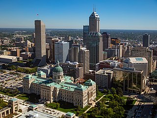
Downtown Indianapolis is a neighborhood area and the central business district of Indianapolis, Indiana, United States. Downtown is bordered by Interstate 65, Interstate 70, and the White River, and is situated near the geographic center of Marion County. Downtown has grown from the original 1821 town plat—often referred to as the Mile Square—to encompass a broader geographic area of central Indianapolis, containing several smaller historic neighborhoods.
The Toledo–Lucas County Port Authority is a port authority financing and/or operating air, rail, trucking, and port facilities, as well as supporting and funding economic development activities in Lucas County, located in northwest Ohio and bordering on southeast Michigan.
The Bates–Hendricks neighborhood is situated just south and east of the downtown commercial district of Indianapolis, Indiana. The Fountain Square business district is just to the east.
Indianapolis Regional Airport is a public use airport in Hancock County, Indiana, United States. Owned by Indianapolis Airport Authority, it is 12 nautical miles (22 km) east of the central business district of Indianapolis. The airport is also 7 nautical miles (13 km) northwest of Greenfield and 3 nautical miles (6 km) southwest of McCordsville. It was known as Mount Comfort Airport until March 2011.

Indianapolis Metropolitan Airport is a public airport in Fishers, Hamilton County, Indiana, United States. It is 8 miles (13 km) northeast of downtown Indianapolis, is owned by the Indianapolis Airport Authority and is a reliever airport for Indianapolis International Airport.
Hendricks County Airport, also known as Gordon Graham Field, is a public airport at 2749 Gordon Graham Blvd. in Danville, a town in Hendricks County, Indiana, United States. Owned by the Indianapolis Airport Authority, it is located 13 miles (21 km) west of the central business district of Indianapolis and serves as a reliever airport for Indianapolis International Airport. The airport is also two miles (3 km) southeast from the center of Danville.
Indianapolis Airport may refer to airports around Indianapolis, Indiana, USA:

The Government of Indianapolis—officially the Consolidated City of Indianapolis and Marion County—is a strong-mayor form of mayor-council government system. Local government is headquartered downtown at the City-County Building.
Transportation in Indianapolis consists of a complex network that includes a local public bus system, several private intercity bus providers, Amtrak passenger rail service, four freight rail lines, an Interstate Highway System, an airport, a heliport, bikeshare system, 115 miles (185 km) of bike lanes, and 116 miles (187 km) of trails and greenways. The city has also become known for its prevalence of electric scooters.

Indiana is a state in the Midwestern region of the United States. It borders Lake Michigan to the northwest, Michigan to the north and northeast, Ohio to the east, the Ohio River and Kentucky to the south and southeast, and the Wabash River and Illinois to the west. Nicknamed "the Hoosier State", Indiana is the 38th-largest by area and the 17th-most populous of the 50 states. Its capital and largest city is Indianapolis. Indiana was admitted to the United States as the 19th state on December 11, 1816.

Indianapolis Downtown Heliport is a heliport located in the city center of Indianapolis. The heliport was opened in 1969 as a private use heliport under the name Beeline Heliport and, in 1979, was turned into a public facility operated by the Indianapolis Airport Authority (IAA). In 1983, the FAA picked the heliport to be part of its National Prototype Demonstration Heliport Program, a project launched to illustrate the usefulness and viability of full-service downtown heliports in the United States, and as a result it received considerable funding for improvements and expansion. It currently has one main pad for landing, an apron, and two hangars. IFR approaches are possible.

The New York metropolitan area has the busiest airport system in the United States and the second busiest in the world after London. It is also the most frequently used port of entry and departure for international flights. In 2011, more than 104 million passengers used the airports under the auspices of the Port Authority of New York and New Jersey (PANYNJ). The number increased to 117 million in 2014.
The economy of Indianapolis is centered on the City of Indianapolis and Marion County within the context of the larger Indianapolis metropolitan area. The Indianapolis–Carmel–Anderson, IN MSA, had a gross domestic product (GDP) of $134 billion in 2015. The top five industries were: finance, insurance, real estate, rental, and leasing ($30.7B), manufacturing ($30.1B), professional and business services ($14.3B), educational services, health care, and social assistance ($10.8B), and wholesale trade ($8.1B). Government, if it had been a private industry, would have ranked fifth, generating $10.2 billion.