
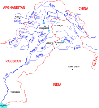
The Indus is a transboundary river of Asia and a trans-Himalayan river of South and Central Asia. The 3,120 km (1,940 mi) river rises in mountain springs northeast of Mount Kailash in Western Tibet, flows northwest through the disputed region of Kashmir, bends sharply to the left after the Nanga Parbat massif, and flows south-by-southwest through Pakistan, before emptying into the Arabian Sea near the port city of Karachi.

The Beas River is a river in north India. The river rises in the Himalayas in central Himachal Pradesh, India, and flows for some 470 kilometres (290 mi) to the Sutlej River in the Indian state of Punjab. Its total length is 470 kilometres (290 mi) and its drainage basin is 20,303 square kilometres (7,839 sq mi) large.

The Ravi River is a transboundary river crossing northwestern India and eastern Pakistan. It is one of five rivers associated with the Punjab region.

The Mangla Dam is a multipurpose dam situated on the Jhelum River in the Mirpur District of Azad Kashmir, Pakistan. It is the sixth-largest dam in the world. The village of Mangla, which sits at the mouth of the dam, serves as its namesake. In November 1961, the project's selected contractors were revealed; it was announced that Binnie & Partners, a British engineering firm, was going to serve as the lead designers, engineers, and inspectors for the construction of the dam. The project was undertaken by a consortium known as the Mangla Dam Contractors, which consisted of eight American construction firms sponsored by the Guy F. Atkinson Company based in South San Francisco, California.

The Satluj River is the longest of the five rivers that flow through the historic crossroads region of Punjab in northern India and Pakistan. The Sutlej River is also known as Satadru. It is the easternmost tributary of the Indus River. The Bhakra Dam is built around the river Sutlej to provide irrigation and other facilities to the states of Punjab, Rajasthan and Haryana.
Topi is a town in the eastern part of the Swabi District of Khyber Pakhtunkhwa province of Pakistan. The administrative division of Topi unfolds into two Union councils: Topi East and Topi West. Notably, the Tarbela Dam, largest earth-filled dam in the world, is located only 9 kilometres (5.6 mi) east of Topi.

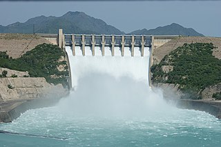
Tarbela Dam is an earth-filled dam along the Indus River in Pakistan's Khyber Pakhtunkhwa province. It is located mainly in the Swabi District Tehsil Topi of the province. It is about 20 km (10 mi) from the city of Swabi KPK, 105 km (65 mi) northwest of Islamabad, and 125 km (80 mi) east of Peshawar. It is the largest earth-filled dam in the world. The dam is 143 metres (470 ft) high above the riverbed and its reservoir, Tarbela Lake, has a surface area of approximately 250 square kilometres (97 sq mi).
The Indus Water Treaty (IWT) is a water-distribution treaty between India and Pakistan, arranged and negotiated by the World Bank, to use the water available in the Indus River and its tributaries. It was signed in Karachi on 19 September 1960 by then Indian Prime Minister Jawaharlal Nehru and then Pakistani president Ayub Khan.
Diamer-Bhasha Dam is a concreted-filled gravity dam, in the preliminary stages of construction, on the River Indus between Kohistan district in Khyber Pakhtunkhwa and Diamer district in Gilgit Baltistan, Pakistan administered Kashmir. Its foundation stone was laid by the then Prime Minister of Pakistan in 1998. The dam site is situated near a place called "Bhasha", hence the name which is 40 km downstream of Chilas town and 315 km from Tarbela Dam. The eight million acre feet (MAF) reservoir with 272-metre height will be the tallest roller compact concrete (RCC) dam in the world.

Baglihar Dam, also known as Baglihar Hydroelectric Power Project, is a run-of-the-river power project on the Chenab River in the Ramban district of Jammu and Kashmir, India. The first power project executed by the Jammu and Kashmir Power Development Corporation, it was conceived in 1992 and approved in 1996, with construction begun in 1999. The project was estimated to cost US$1 billion. The project consists of two-stage of 450MW each. The first stage of the project was completed in 2008-09 and was dedicated to the nation by the Prime Minister Manmohan Singh of India. The second stage of the project was completed in 2015–16, and was subsequently dedicated to the nation by the Prime Minister Narendra Modi of India.

Ghazi-Barotha Hydropower Project is a 1,450 MW run-of-the-river hydropower, connected to the Indus River. It is located about 10 km (6.2 mi) west of Attock in the Punjab province and east of Haripur in the Khyber Pakhtunkhwa province of Pakistan. Construction of the project began in 1995. It consists of five generators, each possessing a maximum power generation capacity of 290 MW. The inauguration of the plant took place on 19 August 2003, presided over by the then President General Pervez Musharraf. It also saw the commissioning of the first two of the five generators i.e. Unit 1 and Unit 2. The last generator was commissioned on 6 April, 2004, and the project was completed by December the same year. It costed US$2.1 billion with funding from Pakistan's Water and Power Development Authority, the World Bank, Asian Development Bank, Japan Bank for International Cooperation, Kreditanstalt für Wiederaufbau, European Investment Bank and Islamic Development Bank.

Salal Dam, also known as Salal Hydroelectric Power Station, is a run-of-the-river hydropower project on the Chenab River in the Reasi district of the Jammu and Kashmir. It was the first hydropower project built by India in Jammu and Kashmir under the Indus Water Treaty regime. After having reached a bilateral agreement with Pakistan in 1978, with significant concessions made to Pakistan in the design of the dam, reducing its height, eliminating operating pool, and plugging the under-sluices meant for sediment management, India completed the project in 1987. The concessions made in the interest of bilateralism damaged the long-term sustainability of the dam, which silted up in five years. It currently runs at 57% capacity factor. Its long-term future is uncertain.

Water conflict typically refers to violence or disputes associated with access to, or control of, water resources, or the use of water or water systems as weapons or casualties of conflicts. The term water war is colloquially used in media for some disputes over water, and often is more limited to describing a conflict between countries, states, or groups over the rights to access water resources. The United Nations recognizes that water disputes result from opposing interests of water users, public or private. A wide range of water conflicts appear throughout history, though they are rarely traditional wars waged over water alone. Instead, water has long been a source of tension and one of the causes for conflicts. Water conflicts arise for several reasons, including territorial disputes, a fight for resources, and strategic advantage.

The topography of Pakistan is divided into seven geographic areas: the northern highlands, the Indus River plain, the desert areas, the Pothohar Plateau, Balochistan Plateau, Salt Range, and the Sistan Basin. All the rivers of Pakistan, i.e. Sindh, Ravi River, Chenab River, Jhelum River, and Sutlej River, originate from the Himalayas mountain range. Some geographers designate Plateau as to the west of the imaginary southwest line; and the Indus Plain lies to the east of that line.
The Kishanganga Hydroelectric Project is a run-of-the-river hydroelectric scheme in Jammu and Kashmir, India. Its dam diverts water from the Kishanganga River to a power plant in the Jhelum River basin. It is located near Dharmahama Village, 5 km (3 mi) north of Bandipore in the Kashmir valley and has an installed capacity of 330 MW.
The Indus Basin Replacement Works, also known as the Indus Basin Settlement Plan, was carried out in Pakistan's Indus Basin Irrigation System, which is one of the world's largest continuous irrigation systems. The replacement works were implemented to provide Pakistan with enough water for irrigation needs following the Indus Waters Treaty between India and Pakistan. The treaty gave the rights to three eastern rivers of the Indus Basin to India, and to make up for this loss of water a network of dams and link canals was built to haul water from the western Indus tributaries Jhelum and Chenab to the eastern Ravi, Sutlej and Beas rivers. The government of Pakistan built the Tarbela Dam and Mangla Dam and a number of barrages now managed by Punjab Irrigation Department under the Indus Basin Replacement Works. Eight inter-river canals were also built between western and eastern rivers. It is due to the connectivity between these rivers that Pakistan's irrigation system is called a contiguous irrigation system.

Punjab Irrigation Department, Pakistan, is a provincial irrigation department in the Punjab province of Pakistan. Punjab Irrigation Department irrigates 21 million acres (8,500,000 ha) of agricultural land in Punjab. Dr. Wasif khurshid, Secretary to the government of the Punjab, is the administrative head of the department.
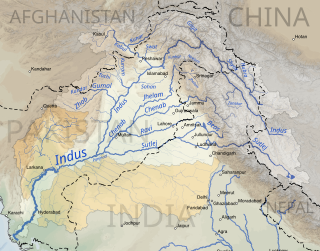
The Indus basin is the part of Asia drained by the Indus river and its tributaries. The basin covers an area of 1,120,000 km2 (430,000 sq mi) traversing four countries: Afghanistan, China, India and Pakistan, with most of the area lying predominantly in the latter two countries.

Soan Dam is a proposed dam on the Soan River in the Potohar region of Pakistan. The dam has a proposed storage capacity of 38 million acre-feet and a power generation capacity of 5,240 megawatts (MW). The dam is being proposed to address the water scarcity, Flood control/harvesting, energy crisis and Economic recovery of Pakistan.
